


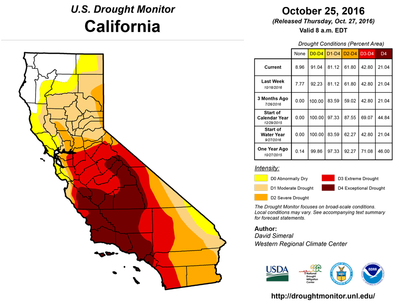
California and National Drought Summary for October 25, 2016
Summary
October 27, 2016 - This U.S. Drought Monitor week saw deterioration in drought conditions across the South and Southeast in an area extending from South Carolina westward to eastern Texas and northward into Tennessee. In the Southeast, a persistent dry weather pattern during the past 60 days continues to negatively impact the agricultural sector as well as hydrologic and soil moisture conditions across much of the region. Elsewhere, significant rainfall accumulations (two-to-six inches) were observed in the Northeast during the past week helping to improve drought-affected areas of western New York, Connecticut, Maine, and Rhode Island. In eastern Ohio, western Pennsylvania, and West Virginia, locally heavy rainfall accumulations led to improvements on the map. Out West, one-to-five inches of precipitation fell in western portions of Oregon and Washington. Recent storm events in the Pacific Northwest during the past 30 days led to improvements on the map in drought-affected areas in Oregon and Washington.The Northeast
On this week’s map, drought-affected areas in western portions of New York saw significant rainfall accumulations ranging from two to six inches leading to one-category improvements in areas of Severe Drought (D2) and Extreme Drought (D3). In northeastern Connecticut and northern Rhode Island, beneficial rainfall during the past week led to a one-category improvement in an area of Severe Drought (D2) where two-to-four inches of precipitation was observed. Rainfall from the same storm event led to a reduction in an area of Extreme Drought (D3) in coastal areas of southern Maine as well as reduction in areas of Abnormally Dry (D0) in northern Maine. Improvements in areas of Massachusetts that received rainfall this week were held status quo in response to lingering, longer-term, hydrologic impacts. Average temperatures were two-to-ten degrees above normal with the greatest temperature anomalies observed in Connecticut, Massachusetts, and Rhode Island.Mid-Atlantic
On this week’s map, improvements in the region were restricted to areas of Pennsylvania and West Virginia that received rainfall. The heaviest rainfall was observed in the western half of Pennsylvania where two-to-six inches of rain fell leading to one-category improvements in areas of Moderate Drought (D1) and Severe Drought (D2). In West Virginia, a large area of Abnormally Dry (D0) was removed in response to one-to-four inches of rain that helped erase short-term precipitation deficits. In the northern half of New Jersey, short-term precipitation deficits and deteriorating hydrologic conditions led to expansion of Severe Drought (D2). In north-central Maryland and western Virginia, short-term precipitation deficits and low streamflows led to expansion of areas of Abnormally Dry (D0). In western North Carolina, short-term precipitation deficits (30–60 day) and reported agricultural impacts led to expansion of areas of Moderate Drought (D1) and Severe Drought (D2). For the week, precipitation was restricted to Pennsylvania and West Virginia while the rest of the region was dry. For the seven-day period, temperatures were two-to-ten degrees above normal.The Southeast
On this week’s map, most of the region saw deterioration in conditions as the dry pattern persisted. Georgia Climate Division CD 1 (Northwest), CD 3 (Northeast), and Alabama CD 2 (Northeast) all recorded their driest 60-day periods on record. Streamflow conditions continued to drop across much of the region, and drought-related impacts are being observed in the agricultural sector. Dry conditions have led to delays in the planting of winter wheat in Alabama. According to the USDA National Agricultural Statistical Service, topsoil moisture conditions (percentage rated short to very short) were as follows: Alabama - 78%, Georgia -73%, and Mississippi - 72%. On the map, areas of Moderate Drought (D1), Severe Drought (D2), Extreme Drought (D3), and Exceptional Drought (D4) expanded in both Alabama and Georgia while western portions of South Carolina saw expansion of areas of Moderate Drought (D1), Severe Drought (D2), and Extreme Drought (D3). In Upstate South Carolina, crop losses (hay) are being reported by the USDA Farm Service Agency. Overall, the region was dry, and average temperatures were one-to-eight degrees above normal with the exception of southern Georgia and Florida where temperatures were slightly below normal.The South
On this week’s map, changes were made in areas across the eastern-third of Texas as well as in the Panhandle. In northeastern Texas, several areas of Severe Drought (D2) were introduced in response to declining stock pond levels and poor grazing conditions. Elsewhere in Texas, short-term dryness led to expansion of areas of Abnormally Dry (D0) and Moderate Drought (D1). In Louisiana, precipitation during the past 60 days has been well below normal leading to expansion of areas of Abnormally Dry (D0) and Moderate Drought (D1) across the state. In Mississippi and Tennessee, deteriorating hydrologic and soil moisture conditions led to expansion of areas of Moderate Drought (D1) and Severe Drought (D2). According to the USDA, cattle operations are reporting significant losses in Giles County, Tennessee. Overall, the region was generally dry this past week, and average temperatures were above normal across most of the region with the exception of southern Louisiana where temperatures were two-to-five degrees below normal.Midwest
The Midwest saw some minor improvements on the map concentrated in eastern Ohio where locally heavy rainfall accumulations (two-to-three inches) led to removal of areas of Abnormally Dry (D0). In Kentucky, short-term precipitation deficits during the past 60 days led to expansion of Moderate Drought (D1) in the south-central region. In Michigan, recent rainfall and improving hydrologic conditions led to removal of two areas of Abnormally Dry (D0). Across the rest of the region, the map remained status quo for the week. Average temperatures were slightly below normal in northern Minnesota while the rest of the region was two-to-eight degree above normal with the greatest anomalies in Kentucky and Ohio.The Plains
Across the Plains, short-term precipitation deficits during the past 30–60 days led to expansion of areas of Abnormally Dry (D0) and Moderate Drought (D1) in the Oklahoma Panhandle and South Dakota. In South Dakota, some agricultural and wildfire-related impacts are being reported. In northeastern Colorado, short-term precipitation deficits during the past 30 days led to expansion of Abnormally Dry (D0). Overall, the region was very dry during the past week with average temperatures ranging from two-to-eight degrees above normal.The West
During the past week, most of the West was very dry with the exception of portions of northern California, western Oregon, western Washington, and the northern Rockies. The heaviest precipitation accumulations were observed in coastal areas and the Cascades of Washington where two-to-five inches were observed. According to the Natural Resource Conservation Service SNOTEL network, Water-Year-to-Date (beginning Oct 1st) precipitation is above normal across the central and northern Sierra, Cascades, and most of the northern Rockies. Also, SNOTEL observations show below normal precipitation across much of the Intermountain West, central and southern Rockies, and the mountains of northern and central Arizona. On this week’s map, improvements were made in south-central, central, and northeastern Oregon as well as in southeastern Washington in response to precipitation events during the past 30 days. In north-central Colorado, mounting precipitation deficits during the past four months led to expansion of an area of Moderate Drought (D1).Hawaii, Alaska, and Puerto Rico
On this week’s map, expansions of areas of Abnormally Dry (D0) were made on the leeward sides of the Big Island, Kauai, Maui, and Oahu. Average temperatures across the Hawaiian Islands were near normal during the past week. Significant rainfall activity in the Hawaiian Islands was restricted to the windward side of Big Island where four-to-five inches fell. In Alaska, no changes were made on this week’s map. Average temperatures were two-to-ten degrees below normal in the Interior while northern, western, and southeastern portions of the state were above normal. Puerto Rico remained status quo on this week’s map.Looking Ahead
The NWS WPC 7-Day Quantitative Precipitation Forecast (QPF) calls for significant precipitation accumulations in northern California (two-to-ten inches) and western portions of Oregon and Washington (two-to-six inches). One-to-two inches of precipitation are forecasted for northern portions of the Midwest, while one-to-four inches are forecasted for the Northeast. Conversely, most of the southern tier of the conterminous U.S. will be dry. The CPC 6–10 day outlooks call for a high probability of above-normal temperatures across the entire conterminous U.S., with the exception of California and western Nevada where there is a high probably of below-normal temperatures. Below-normal precipitation is forecasted for the eastern third of the U.S. as well as the South and Desert Southwest. A high probability of above-normal precipitation is expected across the remainder of the West, Plains, and the western half of the Midwest.Author(s):
David Simeral, Western Regional Climate Center
Dryness Categories
D0 ... Abnormally Dry ... used for areas showing dryness but not yet in drought, or for areas recovering from drought.Drought Intensity Categories
D1 ... Moderate DroughtD2 ... Severe Drought
D3 ... Extreme Drought
D4 ... Exceptional Drought
Drought or Dryness Types
S ... Short-Term, typically <6 months (e.g. agricultural, grasslands)L ... Long-Term, typically >6 months (e.g. hydrology, ecology)
Source: National Drought Mitigation Center