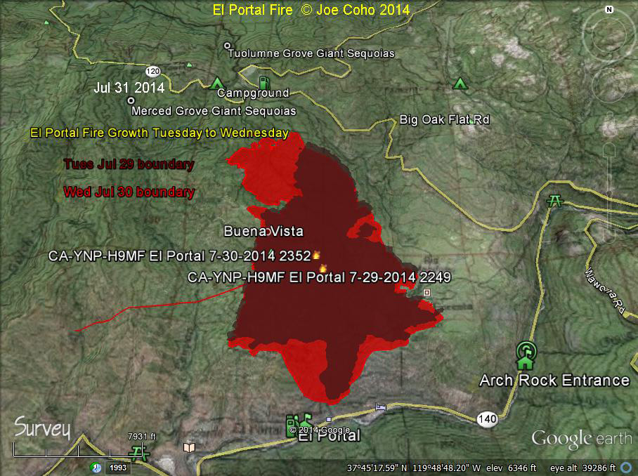
EL Portal Fire 24 hour fire growth from Tues Jul 29 to Wed Jul 30 2014.
The light red shaded area is the additional growth on Wed Jul 30 2014 2352 hrs PDT, expanded from the dark red colored area representing the Tue Jul 29 2014 2249 hrs PDT perimeter.
This fire growth happened in part because smoke kept the large helicopters from being able to fly. In addition, severe fire weather aided the growth of the fire.
We can see that the fire moved both North and Northwest during this period. Along the Southern flank it seems to be held by completed fire lines. (note by Joe Coho)
Evening Update
Incident Overview
The evacuation order will be lifted for the community of Foresta on Friday, August 1 at 3:00 p.m., after which time the residents are allowed to return to their homes.
Basic Information
| Current as of | 7/31/2014 9:02:52 PM |
|---|---|
| Incident Type | Wildfire |
| Cause | Unknown |
| Date of Origin | Saturday July 26th, 2014 approx. 05:00 PM |
| Location | Communities of El Portal, Foresta in Yosemite Park and Stanislaus National Forest |
| Incident Commander | Carlton Joesph |
Current Situation
| Total Personnel | 1,194 |
|---|---|
| Size | 4,198 Acres |
| Percent of Perimeter Contained | 58% |
| Percent of Perimeter To Be Contained | 42% |
| Fuels Involved | Chaparral (6 feet) Brush, Chaparral, grass, Oak, Woodland at lower elevations. Timber (Pine, Cedar) at elevations above 4500 feet. |
| Significant Events | Continued evacuation of Foresta. Fire exhibited moderate fire behavior under more favorable weather allowing for successful activities. |
Outlook
| Planned Actions | Continued mop-up and mitigation of hazards in the community of Foresta. Construct direct and indirect line on the northwest and Northeast portions of the fire. Mop up will continue along the East and West side of the fire. |
|---|---|
| Projected Incident Activity | Despite the winds out of the southwest,fire could spread predominately to the north and northwest because of topography. Potential spread west toward Merced Sequoia Grove and West into Moss Canyon. |
| Remarks | Extremely steep and remote terrain required heavy dependence on Type 1 Hand Crews and aviation assets. Reduction of threat to community of Foresta, but threat still exists with evacuations continuing to allow mop up and hazard mitigation. Fire Suppression Repair Plans are being developed. To date, 3 firefighters have been injured. |
Current Weather
| Weather Concerns |
Poor RH recovery continues to extend the burn period into darkness for the northern end of the fire.
|
|---|
Update: 7:56 P.M.
4,198 Acres, 58% contained.
Update: 11:28 A.M.
The evacuation order will be lifted for the community of Foresta on Friday, August 1 at 3:00 p.m.
EL Portal Fire MODIS Fire Activity 1115 MDT Jul 31 2014.
The satellite signatures are overlaid on the official fire perimeter from Jul 29, 2014 2249 PDT -- the latest available.
The most recent fire signatures are from the Aqua satellite MODIS at 330am PDT July 31.
On Wednesday the fire made some large runs along the Northern boundary toward the West. According to InciWeb, smoke prevented the use of the large type 1 helicopters (Sky Cranes) for much of the day. I personally observed significant fire activity near Little Nellie Falls on Wednesday morning. At that time the Siller type 1 helicopter was working. By nightfall it was possible to observe intense fire activity up the Crane Creek drainage. And near the El Portal NPS facility, one could see a glow up Moss Creek Canyon. (note by Joe Coho)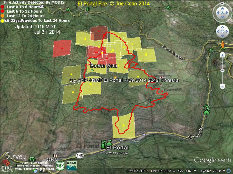
Update: 9:55 A.M.
No additonal acreage added overnight.
New information is highlighted in Bold to the right of the headings.
Basic Information
| Current as of | 7/31/2014 9:47:23 AM |
|---|---|
| Incident Type | Wildfire |
| Cause | Unknown |
| Date of Origin | Saturday July 26th, 2014 approx. 05:00 PM |
| Location | Communities of El Portal, Foresta in Yosemite Park and Stanislaus National Forest |
| Incident Commander | Carlton Joesph |
Current Situation
| Total Personnel | 1,063 |
|---|---|
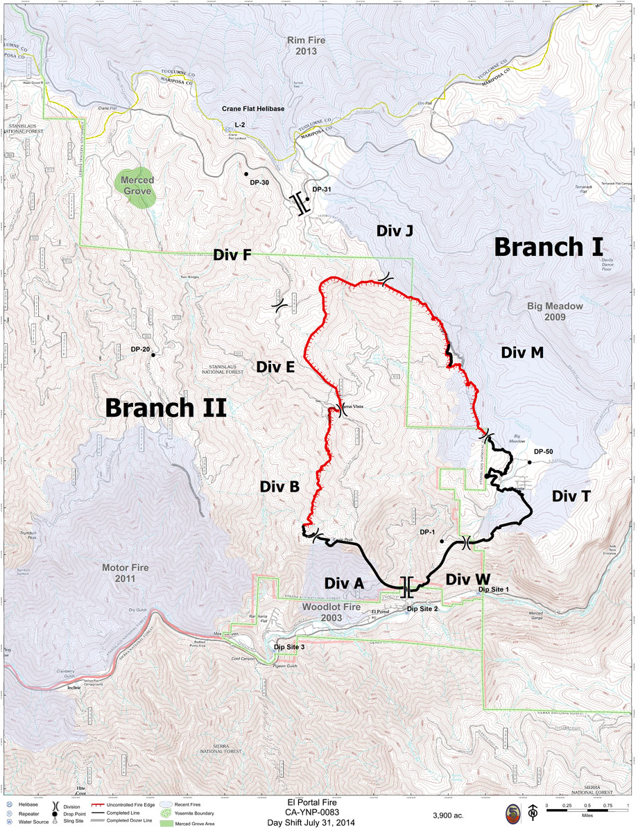
| Size | 3,900 Acres |
| Percent of Perimeter Contained | 34% |
| Percent of Perimeter To Be Contained | 66% |
| Fuels Involved | Chaparral (6 feet) Brush, Chaparral, grass, Oak, Woodland at lower elevations. Timber (Pine, Cedar) at elevations above 4500 feet. |
| Significant Events | Under an unstable air mass, the fire moved 1/2 mile to the northwest demonstrating active fire behavior with spotting. Continued evacuations of Foresta. |
Outlook
| Planned Actions | Continued mop-up and mitigation of hazards in the community of Foresta. Construct direct and indirect line on the northwest and Northeast portions of the fire. Mop up will continue along the East and West side of the fire. |
|---|---|
| Projected Incident Activity | Despite the winds out of the southwest,fire could spread predominately to the north and northwest because of topography. Potential spread west toward Moss Canyon. |
| Remarks | Extremely steep and remote terrain required heavy dependence on Type 1 Hand Crews and aviation assets. Reduction of threat to community of Foresta, but threat still exists with evacuations continuing to allow mop up and hazard mitigation. Fire Suppression Repair Plans are being developed. To date, 3 firefighters have been injured. |
Current Weather
| Weather Concerns | The dry air mass that set up over the fire encouraged the active fire behavior today. The threat of thunderstorms were carefully monitored throughout the operational period. |
|---|
Map showing dozer lines and firebreak lines
'Click' here to view larger map