


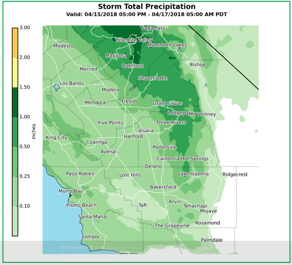
April 15, 2018 - The National Weather Service Hanford office expects around 1.00" of rain for Mariposa and Oakhurst with the next weather system to enter the area on Sunday afternoon.
NWS: A storm system is expected to move in Sunday night through Monday, bringing rain and snow along with gusty winds and much cooler temperatures. Dry and mild again Tuesday and Wednesday, then more wet weather is possible by Thursday.
Discussion: Big weather changes are in store for the central California interior during the next 48 hours. In the short term, high clouds will stream in over much of central California today on southwesterly winds aloft. Although these cirrus clouds will be opaque at times, we should get enough filtered sunshine to boost temperatures toward yesterday`s levels. Enjoy the mild weather today. It won`t last long.
A storm system that originated in the Gulf of Alaska will sweep a cold front southward through the CWA later tonight and set us back to Winter. The change will be abrupt, and it will be accompanied by blustery winds, falling temperatures and some precipitation when the cold front breezes through the region.
Overall, QPF will be relatively light with this storm system. Most of it`s precip will fall over the higher elevations of the Sierra where totals of three quarters of an inch to just over an inch are likely. In the San Joaquin Valley, rain amounts will generally be less than a tenth of an inch on the west side to almost a third of an inch on the east side.
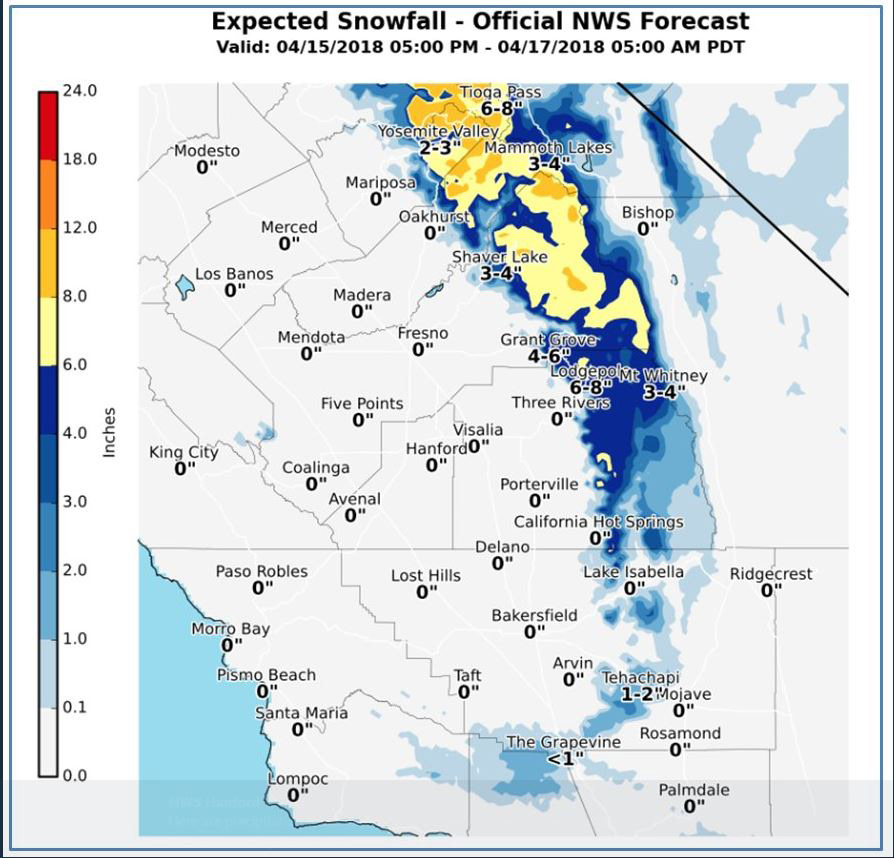
Nonetheless, the cold air that follows this front will drop snow levels as low as 3500 feet by Monday evening. A dusting of snow is possible down to this elevation by then while a general 3 to 7 inches of snow may accumulate at higher elevations. There might be just enough snow to create hazardous winter driving conditions in the mountains, not just in the Sierra, but also down to pass level in Kern County by late Monday night.
We`ve issued Winter Weather Advisories accordingly from Yosemite National Park southward into the Tehachapi mountains with the timing of cold air advection southward.
Additionally, in the post frontal environment, the atmosphere will become unstable Monday, so isolated thunderstorms with small hail could develop just about anywhere by Monday afternoon and mainly north of Kern county where the atmosphere will be most unstable.
Winter Weather Advisory
URGENT - WINTER WEATHER MESSAGE...CORRECTED
National Weather Service Hanford CA
351 AM PDT Sun Apr 15 2018

Sierra Nevada from Yosemite to Kings Canyon-
Including the cities of Devils Postpile, Florence Lake,
Lake Thomas Edison, Tuolumne Meadows, Bass Lake, Fish Camp,
and Wawona
351 AM PDT Sun Apr 15 2018

...WINTER WEATHER ADVISORY IN EFFECT FROM 8 PM THIS EVENING TO
11 PM PDT MONDAY...

The National Weather Service in Hanford has issued a Winter
Weather Advisory for the southern Sierra from Yosemite National
Park to Kings Canyon...which is in effect from 8 PM this evening
to 11 PM PDT Monday.

* Snow accumulations of generally 3 to 7 inches by Monday evening.
  Snow levels initially around 8000 feet this evening, lowering to
  near 4000 feet by late in the day Monday.

* MAIN IMPACT...Snow covered roads and slick driving conditions.
  Strong winds and blowing snow over the higher elevations. Travel
  delays and possible road closures. Tire chains may be required.

* OTHER IMPACTS...Hikers and campers in the high country should
  expect an abrupt change to colder, wintry weather tonight and
  Monday with wind chill temperatures in the single digits and
  teens.

PRECAUTIONARY/PREPAREDNESS ACTIONS...

A Winter Weather Advisory means that periods of snow will cause
travel difficulties. Be prepared for slippery roads and limited
visibilities, and use caution while driving.
Source: NWS

