


Statistics
California and National Drought Summary for April 17, 2018
Summary
April 19, 2018 - A powerful spring storm emerged from the West and brought extreme conditions to several regions. For example, historic, late-season snow blanketed portions of the northern Plains, upper Midwest, and Great Lakes region, snarling traffic and severely stressing livestock. Meanwhile, dry, windy weather contributed to a major wildfire outbreak, starting on April 12, and led to blowing dust and further reductions in rangeland, pasture, and crop conditions. Farther east, heavy showers and locally severe thunderstorms swept across portions of the southern and eastern U.S. Elsewhere, unsettled, showery weather lingered in the Northwest, extending as far south as northern California.
Northeast
A storm system crossing the Northeast on April 15-16 delivered widespread rain and—in northern areas—some wintry precipitation. The U.S. Department of Agriculture reported topsoil moisture approximately one-half surplus on April 15 in Maine (51% surplus), New York (49%), and Delaware (48%). The storm, which produced 1- to 3-inch rainfall totals in many areas, resulted in a reduction in the coverage of abnormal dryness (D0) and moderate drought (D1) in the northern Mid-Atlantic region.
Southeast
A cold front sweeping across the Southeast from April 14-16 produced heavy showers and locally severe thunderstorms. As a result, there were substantial reductions in the coverage of abnormal dryness (D0) and moderate drought (D1) from Alabama to Virginia. In general, rainfall was lighter east of the Appalachians, resulting in fewer improvements—and even some increase in drought coverage—in the southern Atlantic region. For example, there was a slight increase in coverage of moderate and severe drought (D1 and D2) in southern Florida, while D2 persisted in many areas along and near the Atlantic Coast in Georgia and South Carolina. Through April 17, year-to-date rainfall in Savannah, Georgia, totaled just 5.24 inches (44% of normal).
South
A sharp line between no drought and moderate to exceptional drought (D1 to D4) continued to slice across Oklahoma and Texas. On April 15, topsoil moisture was rated 72% very short in Oklahoma, along with 66% in Texas. In stark contrast, topsoil moisture was at least one-third surplus in Mississippi (58%), Tennessee (41%), Arkansas (37%), and Louisiana (34%). In the drought-affected areas, rangeland, pastures, and winter grains continued to greatly suffer. On April 15, nearly two-thirds of the winter wheat was rated in very poor to poor condition in Oklahoma (65%) and Texas (63%). On April 12-13 and 16-17, high-wind events brought blowing dust and a rash of major wildfires to western Oklahoma and portions of neighboring states. As of April 17, the two largest wildfires in Oklahoma had charred more than 300,000 acres of grass and brush and had destroyed more than 100 structures. The Rhea Fire, in Dewey County, had consumed more than one-quarter million acres, while the 34 Complex, in Woodward County, had burned across nearly 70,000 acres.
Midwest
A major, late-season storm dumped heavy snow across much of the northern half of the region, sharply reducing the coverage of abnormal dryness (D0). In Wisconsin, April 13-16 storm-total snowfall included 24.2 inches in Green Bay and 20.7 inches in Wausau. In both locations, it was the biggest April storm (previously, 11.0 inches in Green Bay on April 4-5, 1977, and 12.1 inches in Wausau on April 15-16, 1993) and the second-highest event total on record. Green Bay’s greatest snowfall occurred on March 1-2, 1888, with 29.0 inches; Wausau’s biggest snowfall, on March 5-6, 1959, was 22.1 inches.
High Plains
Heavy snow also blanketed portions of the northern Plains, while dry, windy weather dominated drought-affected areas of the central Plains. The storm contributed to the elimination of severe drought (D2) from the Dakotas, and brought substantial reductions in the coverage of abnormal dryness (D0) and moderate drought (D1). In South Dakota, 2-day April snowfall records were broken on April 13-14 in Mitchell (16.2 inches) and Huron (15.5 inches), while peak gusts were clocked to 60 and 57 mph, respectively. Sioux Falls, South Dakota, received 14.5 inches of snow from April 13-15, and reported a gust to 67 mph on the 14th. Most of Sioux Falls’ snow—13.7 inches—fell on the 14th, easily becoming the snowiest April day on record in that location (previously, 10.5 inches on April 28, 1994). Farther south, however, topsoil moisture was rated 72% very short to short on April 15 in Kansas, along with 61% in Colorado. On the same date, winter wheat in Kansas was rated 46% very poor to poor. In Colorado, there was a significant introduction of exceptional drought (D4) into the southwestern corner of the state, where winter snowfall was abysmal and spring and summer runoff prospects are poor.
West
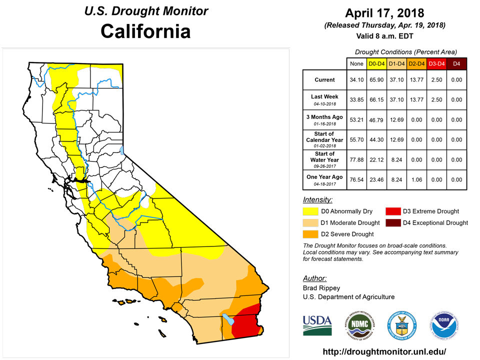
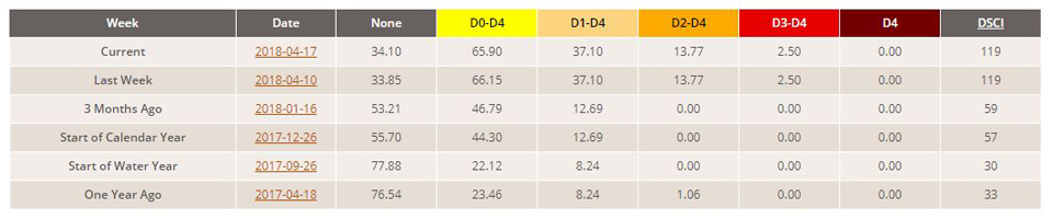
Late-season precipitation continued to move ashore as far south as northern California, resulting in some minor reductions in the coverage of abnormal dryness (D0). In the Southwest, however, dry, often windy weather resulted in drought persistence or intensification. Arizona’s rangeland and pastures were rated 86% very poor to poor on April 15, compared to the 5-year average of 30%. On the same date, New Mexico’s rangeland and pastures were rated 50% very poor to poor, while winter wheat was rated 68% very poor to poor. New Mexico’s topsoil moisture on April 15 was rated 91% very short to short. Due to deteriorating agricultural and hydrological conditions, exceptional drought (D4) was expanded in the Four Corners region as well as northeastern New Mexico.
Alaska, Hawaii, and Puerto Rico
Neither dryness nor drought was observed in Hawaii and Puerto Rico. In Alaska, there were no changes to the depiction, although recent precipitation in the southeastern part of the state resulted in some improvement with respect to the generation of hydroelectric power. Nevertheless, significant cold-season snowpack and precipitation deficits exist across southeastern Alaska.
Looking Ahead
A storm system crossing the nation’s northern tier will reach the Northeast on Thursday, bearing rain and snow. A more significant storm will traverse the West and produce heavy snow in the central Rockies before crossing the Plains on Friday. Precipitation totals associated with the storm will be variable, but some drought-stricken areas of the central and southern Plains could receive as much as 0.5 to 2.0 inches of rain. During the weekend, showers and thunderstorms will erupt across the mid-South and spread into the Southeast. By early next week, warm, dry weather should overspread much of the western U.S., while chilly conditions will linger across the South and East.
The NWS 6- to 10-day outlook for April 24 – 28 calls for the likelihood of near- to below-normal temperatures across most of the eastern half of the U.S., while warmer-than-normal weather will cover the West. Meanwhile, near- to below-normal precipitation across the majority of the country should contrast with wetter-than-normal conditions in a few areas, including the Atlantic Coast States and central and southern sections of the Rockies and High Plains.
Author(s):
Brad Rippey, U.S. Department of Agriculture
Dryness Categories
D0 Abnormally Dry—used for areas showing dryness but not yet in drought, or for areas recovering from drought.
Drought Intensity Categories
D1 Moderate Drought
D2 Severe Drought
D3 Extreme Drought
D4 Exceptional Drought
Drought or Dryness Types
S Short-Term, typically less than 6 months (e.g. agricultural, grasslands)
L Long-Term, typically greater than 6 months (e.g. hydrologic, ecologic)
National Drought Mitigation Center
