Fire in El Portal Near Yosemite National Park on Friday, August 1, 2014
Click here for Information from Thursday, July 31, 2014
Update: 9:00 P.M.
Incident Overview
Law enforcement personnel escorted residents of Foresta to their homes this afternoon.
The community will be open to the general public tomorrow, Saturday, August 2, at 10:00 a.m.
More up-to-date information on the fire will be available in this evening's 8:00 update.
Basic Information
| Current as of | 8/1/2014 7:16:17 PM |
|---|---|
| Incident Type | Wildfire |
| Cause | Unknown |
| Date of Origin | Saturday July 26th, 2014 approx. 05:00 PM |
| Location | Communities of El Portal, Foresta in Yosemite Park, and Stanislaus National Forest |
| Incident Commander | Carlton Joesph |
Current Situation
| Total Personnel | 1,341 |
|---|---|
| Size | 4,518 Acres |
| Percent of Perimeter Contained | 78% |
| Percent of Perimeter To Be Contained | 22% |
| Estimated Containment Date | Friday August 08th, 2014 approx. 12:00 AM |
| Fuels Involved | Chaparral (6 feet) brush, chaparral, grass, oak woodland at lower elevations. Timber (pine and cedar) at elevations above 4,500 feet. |
| Significant Events | The community of Foresta, where electrical power was restored today, has been repopulated. Crews completed firing operations on the northern perimeter of the fire. |
Outlook
| Planned Actions | Hold and aggressively mop up recently completed firing operations on the north, east, and west sides of the fire. |
|---|---|
| Projected Incident Activity | Fire spread predominantly to the north and northwest. Continued spread to the north toward state highway 120 and Crane Flat. |
| Remarks | Excess Type 1 and Type 2 helicopters will be released starting at 4:00 p.m. on August 1. Excess Type 1 interagency hotshot crews will be released starting the morning of August 2. Fire suppression repair operations have are being implemented. Of the fire's total current acreage, 3,542 acres are US Forest Service lands and 985 acres are National Park Service lands. |
Current Weather
| Weather Concerns | Weather in the fire area will become hotter and drier through the weekend. Today was evidence of that as the relative humidity on the northern part was 10 percent lower than yesterday. |
|---|
August 1, 2014, 8:00 P.M.
Fire Start: July 26, 2014, 5:00 P.M.
Location: Old El Portal and Foresta
Cause: under investigation
Size: 4,518 acres
Percent Contained: 78%
Total Number of Personnel: 1,341
Costs to Date: $8 million
Expected containment date: August 9, 2014
Incident Commander: Carlton Joseph/California Interagency Incident Management Team 5 (CIIMT5)
Fire Summary: Today crews made excellent progress with burnout operations on the north end of the fire. Weather conditions were in their favor, and they completed a black line around the fire’s edge. They are working to mop up and strengthen the line. A spot fire, approximately 100’ x 100’, was quickly contained in the northeast corner. Logs and other large fuels burning in the interior are producing visible smoke, but they pose no threat to the containment line.Two helicopters were released from the El Portal Fire to assist at the neighboring French Fire this afternoon. Over the next few days many crews will be released from the El Portal suppression effort and potentially reassigned to other fires throughout the West.The National Park Service escorted a convoy of residents into Foresta this afternoon; this was the first time in nearly a week that they were allowed to enter their homes. Power was restored by the Pacific Gas and Electric Company at approximately 4:00 P.M. today.
Information Phones: El Portal Fire Call Center is open from 7:00 A.M. to 9:00 P.M. every day: (209) 372-0327, (209) 372-0328, and (209) 372-0329.
Smoke issues on the El Portal Fire:
Smoke sensitive individuals such as elders, children, pregnant women, and people with heart or lung disease are vulnerable to the adverse health effects of smoke. Please avoid prolonged or strenuous outdoor activity. You may consider leaving the area until smoke levels decline. Please consult your healthcare provider to discuss protective measures. For more information, visit one of the following websites:
For health effects of smoke: www.mariposacounty.org/index.aspx?NID=89
For Yosemite air quality: www.nps.gov/yose/naturescience/aqmonitoring.htm
For smoke updates: www.californiasmokeinfo.blogspot.com
Update: 2:30 P.M.
The Foresta community will be open to the general public tomorrow, Saturday, August 2, at 10:00 a.m.
Update: 2:22 P.M.
El Portal Fire MODIS Fire Activity 1430 MDT Aug 1 2014.
The red boundary is the fire perimeter for July 31 2014 at about 2200 hours PDT.
This map shows fire activity near CRANE FLAT in Yosemite National Park. The green line is the park boundary. The purple area is the fire perimeter as of July 31 2014 at about 2200 hours PDT. The most recent fire activity signatures are from the Terra satellite at 1156 AM PDT (indicated by the bright red footprint).
The map shows the location of the Giant Sequoia groves and the Crane Flat campground. (note by Joe Coho)
Thanks to Joe Coho for the Map.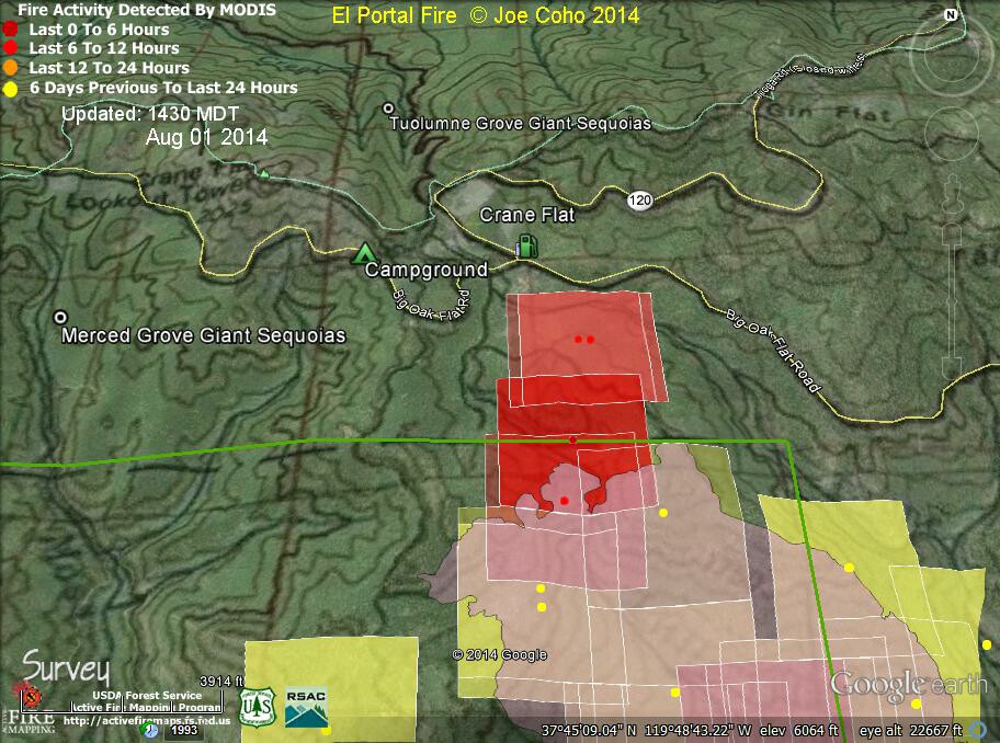
Update: 12:22 P.M.
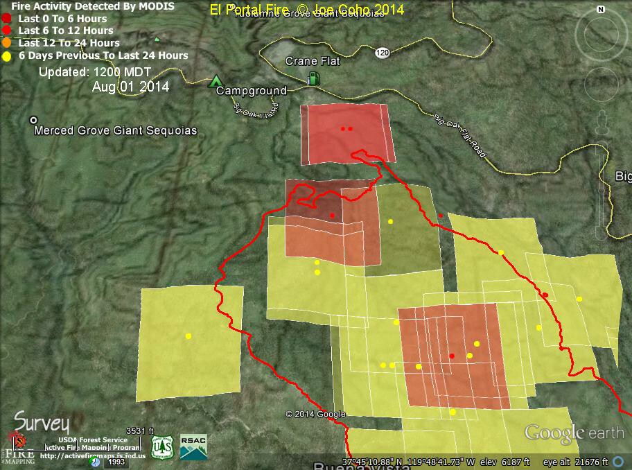
El Portal Fire MODIS Fire Activity 1200 MDT Aug 1 2014. The red boundary is the fire perimeter for July 31 2014 at 2202 hours PDT.
These two maps show recent fire activity detections as of 235 AM Friday Aug 1 2014 by the Aqua satellite. These are the red areas on the map.
The second map is a close up of the first centered on the Crane Flat area. It shows the Crane Flat campground and gas station. Nearby is the Merced Grove of Giant Sequoias.
(note by Joe Coho)
Thanks to Joe Coho for the maps.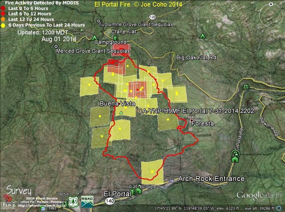
Update: 7:16 A.M.
4,198 Acres and 58% Containment
An Unofficial Report has 4,518 acres.
The evacuation order will be lifted for the community of Foresta on Friday, August 1 at 3:00 p.m., after which time the residents are allowed to return to their homes.
Basic Information
| Current as of | 8/1/2014 7:03:27 AM |
|---|---|
| Incident Type | Wildfire |
| Cause | Unknown |
| Date of Origin | Saturday July 26th, 2014 approx. 05:00 PM |
| Location | Communities of El Portal, Foresta in Yosemite Park and Stanislaus National Forest |
| Incident Commander | Carlton Joesph |
Current Situation
| Total Personnel | 1,360 |
|---|---|
| Size | 4,198 Acres |
| Percent of Perimeter Contained | 58% |
| Percent of Perimeter To Be Contained | 42% |
| Fuels Involved | Chaparral (6 feet) Brush, Chaparral, grass, Oak, Woodland at lower elevations. Timber (Pine, Cedar) at elevations above 4500 feet. |
| Significant Events | Planned re-population of the community of Foresta on 8/1 at 1500 hours. The fire was active again last night in the thermal belt but minimal elsewhere on the fire. |
Outlook
| Planned Actions | Repopulated the community of Foresta. Continued mop-up on the East and West sides of the fire. Construct direct and indirect line on the Northwest and Northeast portions of the fire. Continued the firing operation on the North side of the fire. |
|---|---|
| Projected Incident Activity | Despite the winds out of the southwest,fire could spread predominately to the north and northwest because of topography. Potential spread west toward Merced Sequoia Grove and West into Moss Canyon. |
| Remarks | Extremely steep and remote terrain required heavy dependence on Type 1 Hand Crews and aviation assets. Fire Suppression Repair Plans are being developed. To date, 3 firefighters have been injured. |
Current Weather
| Weather Concerns | Fire Weather will become hotter and drier through the weekend. |
|---|
Map showing dozer lines and firebreak lines
'Click' here to view larger map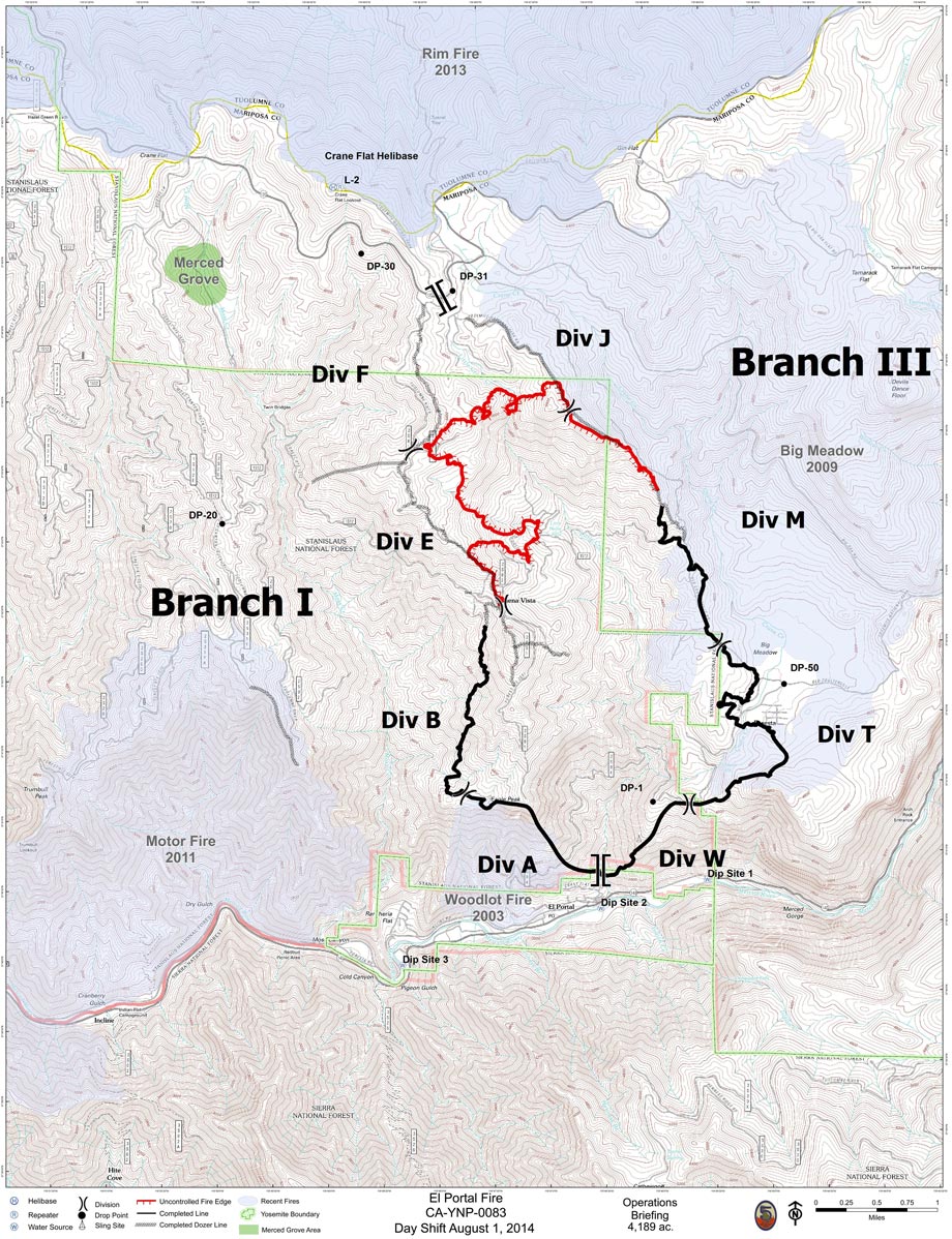
El Portal Fire MODIS Fire Activity 0045 MDT Aug 1 2014.
The red boundary is the fire perimeter for July 30 2014 at 2352 hours PDT.
Two satellites, Terra and Aqua, contain MODIS instruments which provide data which can be interpreted regarding fire activity.
NASA says: "MODIS (or Moderate Resolution Imaging Spectroradiometer) is a key instrument aboard the Terra (EOS AM) and Aqua (EOS PM) satellites. Terra's orbit around the Earth is timed so that it passes from north to south across the equator in the morning, while Aqua passes south to north over the equator in the afternoon."
In these maps, the square footprints indicate the accuracy of the center dots. The colors shade from red to orange to yellow as the time from detection increases.
What you need to know: The red dots and footprints are the most recent activity. They indicate possible fire activity based on certain characteristics of the multispectral image. Even though they are carefully interpreted, they don't guarantee an actual fire on the ground. (note by Joe Coho)
Thanks to Joe Coho for the map.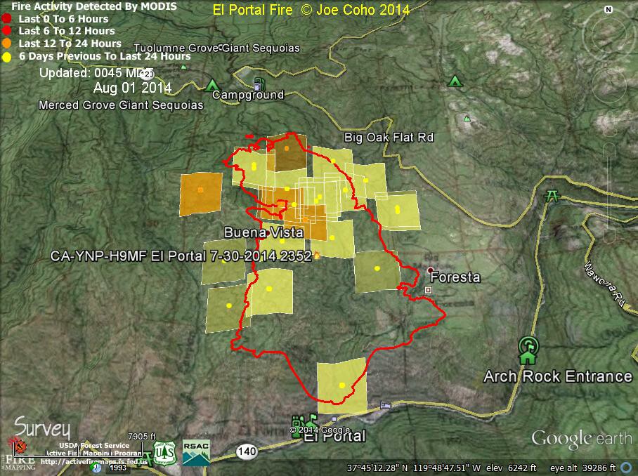
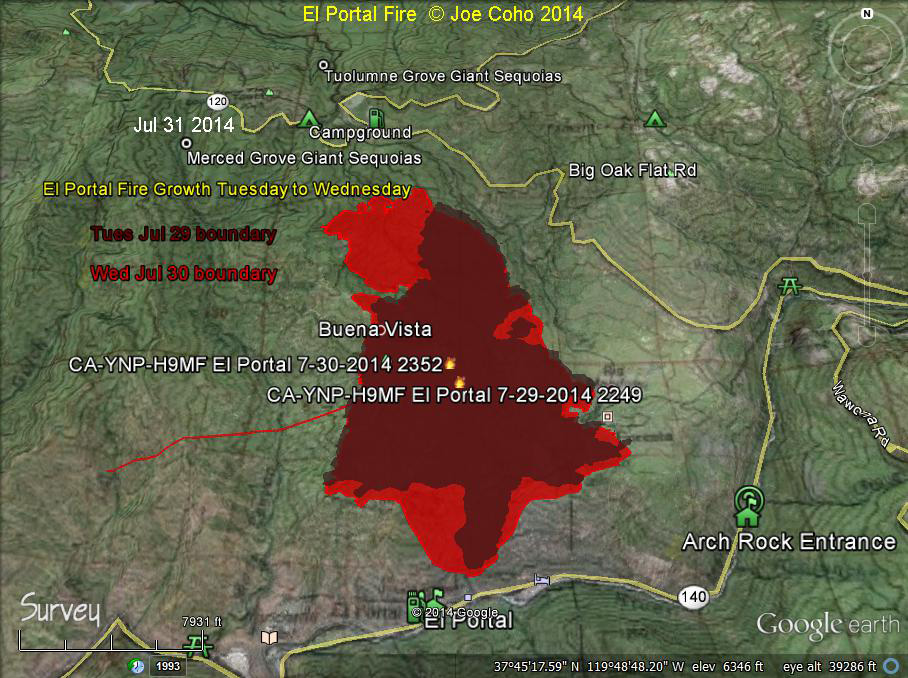
EL Portal Fire 24 hour fire growth from Tues Jul 29 to Wed Jul 30 2014.
The light red shaded area is the additional growth on Wed Jul 30 2014 2352 hrs PDT, expanded from the dark red colored area representing the Tue Jul 29 2014 2249 hrs PDT perimeter.
This fire growth happened in part because smoke kept the large helicopters from being able to fly. In addition, severe fire weather aided the growth of the fire.
We can see that the fire moved both North and Northwest during this period. Along the Southern flank it seems to be held by completed fire lines. (note by Joe Coho)
Thanks to Joe Coho for the map.