


Statistics
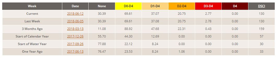
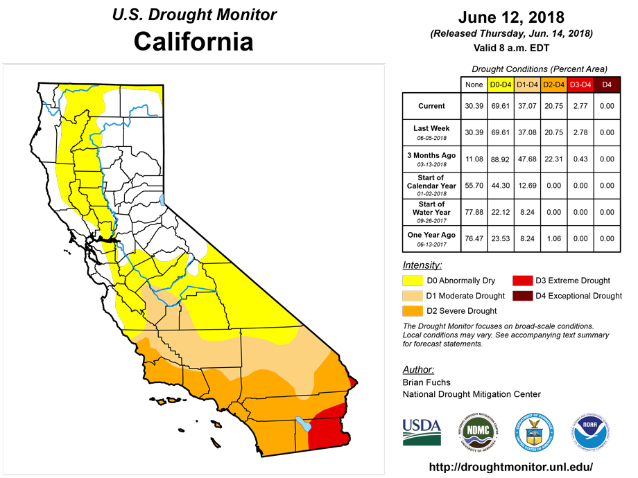
California and National Drought Summary for June 12, 2018
Summary
June 15, 2018 - Over the last week, dry conditions continued in the Desert Southwest and in parts of the Central Rockies, leading to drought persistence and degradation in these areas. Farther east across the Great Plains, scattered thunderstorms led to some areas improving or staying out of drought, while some areas that missed the rain were degraded. In the Upper Midwest and Northern Plains, precipitation patterns also dictated areas which experienced degrading and improving conditions. Near normal or wetter than normal conditions occurred over most of the eastern United States, where few changes to the USDM depiction were made.
Northeast
No changes were made in the Northeast this week. Mostly cooler than normal temperatures prevailed; some parts of New England had temperatures from 4 to 8 degrees cooler than normal. Swaths of above normal rainfall fell over parts of Pennsylvania into the Washington D.C. area, while mainly dry weather occurred north of the Pennsylvania/New York state line. Low streamflow and short term precipitation deficits continued in and near the abnormally dry conditions in New England.
Southeast
The only change needed in the Southeast this week was in northeast Alabama where abnormally dry conditions were shifted northward based on short to medium term precipitation deficits. Widespread precipitation fell over the region, and most areas were within an inch or two of normal for this week.
South
Warm weather occurred over much of the Southern region; the warmest temperatures (6 or more degrees warmer than normal) took place in the Texas Panhandle, western Oklahoma, and the Dallas-Fort Worth Metroplex. Paltry rain amounts for this week combined with high temperatures and long term precipitation deficits added additional stress to the water systems in parts of the Texas Panhandle, leading to the expansion of extreme and exceptional drought conditions. Moderate to heavy rain over the Interstate 35 corridor in Oklahoma and in north-central to west Texas allowed for 1-category improvements in some areas that were experiencing abnormal dryness, moderate drought, severe drought, and extreme drought. Meanwhile, continued dry and hot conditions led to the introduction of extreme drought west of Lubbock and in areas near Corpus Christi where soil moisture deficits and mid to long term precipitation deficits supported degradation. Additionally, extreme drought was expanded in the Del Rio area northeast of the Rio Grande and in a corridor north of Houston and College Station in response to building precipitation deficits in these areas. The drought impact designation in far south Texas was changed from S to SL, indicating that drought conditions are present at both short and long term timescales. Elsewhere in the South, a few areas of abnormal dryness and moderate drought formed or expanded in Louisiana, Mississippi, Arkansas, and eastern Oklahoma that missed out on the moderate to heavy rains in the region.
Midwest
June warmth continued across the Midwest over the past week with temperatures of 6 or more degrees warmer than normal recorded in southwest Illinois, much of Missouri, and central and western Iowa. Although rain occurred over large sections of the region, pockets of continued dryness and high temperatures resulted in low streamflows, soil moisture deficits, and vegetation stress and led to the introduction of severe drought in northeast and central Missouri and southeast Iowa as well as a small expansion of moderate drought. Heavy rains in Illinois, Indiana, and Iowa, led to the removal of all or
parts abnormally dry areas. Farther north, dry conditions in the Michigan Upper Peninsula, northern Wisconsin, and far east-central Minnesota led to the expansion of abnormally dry conditions where short term precipitation deficits continued to build.
High Plains
Significant rainfall fell in parts of the High Plains region, while most of the mountainous areas remained dry. Thunderstorms in northeast Colorado, Nebraska, and northwest and eastern Kansas delivered between 0.5 and 3 inches of rain, helping to prevent additional drying caused by the high temperatures. Similar rainfall totals in southwest Kansas were enough to lessen precipitation deficits and result in an improvement from extreme to severe drought. Aside from the Black Hills, much of the Dakotas saw rainfall amounts over a half inch, with some areas exceeding 2 inches. This rainfall led to the removal of abnormal dryness in some areas west of the Missouri River in South Dakota and far southern North Dakota. Recent rainfall also helped decrease moderate drought in northwest South Dakota, though if recent hot weather and a high atmospheric demand for moisture continues, a reversion back to moderate drought conditions may occur. Severe drought was reduced in coverage in north-central North Dakota, where precipitation deficits over multiple time scales had decreased sufficiently for an improvement. Meanwhile, over the central Rockies, continued warm, dry weather exacerbated longer term precipitation deficits leading to an expansion of drought and abnormal dryness in north-central Colorado and south-central Wyoming.
West
During the past week, precipitation fell in the mountainous areas of western Washington and Oregon, northern and central Idaho, and parts of western Montana. The highest amounts, with isolated spots in the 2 to 3 inch range, fell in western Washington, western Oregon, southwest Montana, and the southern Idaho Panhandle. Precipitation, some heavier, also fell over the high plains of Montana. Elsewhere across the region, conditions were quite dry, aside from some isolated precipitation south of Tucson. In the drier areas of central Washington and north-central Oregon, abnormal dryness developed as 1 to 2 month precipitation deficits increased. Severe drought crept south in southwest and south-central New Mexico due to increasing short- and medium-term precipitation. Relatively cool conditions occurred in most of central and northern California and in much Oregon and Washington, while above normal temperatures were found in eastern Montana, parts of Idaho, Utah, most of Nevada, and Arizona. The warmest areas, primarily in New Mexico and Utah, had temperatures reach at least 6 degrees above normal for the weekly average, while the coolest areas saw mercury drop 4 to 8 degrees below normal.
Alaska, Hawaii, and Puerto Rico
Hawaii, Alaska, and Puerto Rico remained status quo for this week.
Looking Ahead
The National Weather Service medium range forecast calls for two significant areas of wet weather over the next 7 days (June 13 to June 20). Widespread and potentially heavy rainfall is expected to bring 2 to 5 inches of rain to coastal and central Texas and southern Louisiana. Rainfall may also extend into the Southern Plains and the remainder of the Gulf Coast region.
Farther north, showers and thunderstorms are likely from the Northern Rockies to the High Plains and Upper Great Lakes. Rainfall over the northern tier is likely to be locally heavy (3 to 5 inches) creating the potential for isolated flooding. In contrast, dry weather is expected to prevail over the Pacific Coast and the drought inflicted areas of southern California, southern Nevada, and western Utah.
Author(s):
Brian Fuchs, National Drought Mitigation Center
Dryness Categories
D0 Abnormally Dry—used for areas showing dryness but not yet in drought, or for areas recovering from drought.
Drought Intensity Categories
D1 Moderate Drought
D2 Severe Drought
D3 Extreme Drought
D4 Exceptional Drought
Drought or Dryness Types
S Short-Term, typically less than 6 months (e.g. agricultural, grasslands)
L Long-Term, typically greater than 6 months (e.g. hydrologic, ecologic)
Source: National Drought Mitigation Center

