


Statistics
California and National Drought Summary for September 4, 2018
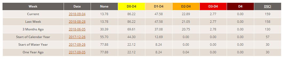
Summary
September 6, 2018 - While subnormal temperatures overspread the Northwest, a strong and persistent Bermuda high over the Atlantic Ocean kept the East unseasonably warm and humid while hindering cold fronts from advancing eastward into the region. As a result, stalled fronts over the Nation’s mid-section became a focal point for widespread heavy showers and thunderstorms, especially from the central Great Plains northeastward into the western Great Lakes region. Parts of Kansas, Nebraska, Missouri, Iowa, Illinois, Wisconsin, and Michigan saw over 5 inches of rain for the week, with locally 10-15 inches of rain in southern Wisconsin. Needless to say, major improvements were made in the Midwest. Tropical showers also occurred along the Gulf Coast, and later in the week Tropical Storm Gordon formed in the eastern Gulf and tracked northwestward toward Mississippi. Scattered showers also fell on parts of the Four Corner Region, the northern Plains, upper Midwest, mid-Atlantic, and western New England. Little or no rain was observed in the West, northern and central Rockies, north-central High Plains, across sections of the interior Southeast, eastern Corn Belt, and coastal New England.
Northeast
Scattered light to moderate showers (0.5-1.5 inches) fell on western sections of New England, providing some slight improvement to small portions of extreme western (near Niagara Falls, D1 to D0) and northwestern New York (near Watertown, D0 to none) as August brought surplus rainfall. In west-central Maine, 1-2.5 inches of rain was enough to produce a 90-day surpluses and remove some D0. Eastern Long Island was reassessed and found to be somewhat wetter than depicted, so some D0 was erased. In contrast, little or no rain and well above-normal (6-10 degsF) temperatures worsened conditions in upstate northeastern New York and northern Vermont (D2), coastal (D2) and east-central Maine (D0), and eastern Massachusetts (D0). 7-day averaged USGS stream flows were in the lower 25th percentile, and reports from northern Vermont indicated poor fall cover crops, smaller than usual fruits, and a large loss in blueberries this year due to a lack of rain.
Southeast
Heaviest rains (1-3 inches, locally to 7 inches) were along the southern Atlantic and Gulf Coasts in association with a westward migrating trough of low pressure early in the week, and newly-formed Tropical Storm Gordon in the eastern Gulf by period’s end. Scattered moderate to heavy (2-4 inches) thundershowers also occurred in Virginia. In-between the two rain areas, little or no precipitation fell as temperatures averaged 2-6 degsF above normal. Although the Southeast has generally seen ample rain this summer, a few pockets of dryness at 60- and 90-days have emerged in southern North Carolina and north-central South Carolina, parts of eastern Georgia, and across northern Alabama and southern Tennessee (D0 expanded or added). 90-day deficits have generally been 1-3 inches, but a few spots have accumulated 4-8 inch deficiencies, thus D1 was added to north-central South Carolina. Most USGS average stream flows are close to normal (25-75th percentile) at 14- and 28-days, but at 1- and 7-days, more sites are dropping below the 25th percentile (below-normal), especially across the aforementioned areas.
South
Early in the week, a trough of low pressure brought scattered showers and thunderstorms to the central and western Gulf, dumping 2-6 inches of rain along the coast, with locally over 10 inches. The rains were enough to eliminate short-term deficits and improve the D0-D1 areas in southern Louisiana and western Mississippi by a category. Scattered showers (1-2 inches) also fell on northwestern Louisiana, shrinking some of the D2 and D3 areas near Shreveport. The Gulf rains also provided relief across southeastern Texas, while heavy Day7 rains (3-8 inches) between Laredo and San Antonio fell on a large D2-D3 area, putting a substantial dent into the drought. North-south bands of scattered showers were observed in portions of central and northeastern Texas, slightly decreasing the D2 and D3areas. In western Texas, a calibration between the radar-based precipitation totals (AHPS) versus gauge-based (ACIS) and other indices showed a wet bias in the radar-based precipitation, thus some additional deterioration was shown in this region, with more areas of D2 and D3 depicted. A spot of D4 was added near Amarillo. In addition, the fifth warmest summer on record for Texas exacerbated the dryness. In Oklahoma, spotty rains (1-2 inches) eased drought in the extreme western Panhandle, and in southwestern and northeastern sections. Similarly, scattered rains in extreme northern and eastern Arkansas erased some D0 there.
Midwest
Slow-moving bands of showers and thunderstorms trained over the same locations (from northeastern Kansas/southeastern Nebraska into most of Missouri, southern and eastern Iowa, northern Illinois, southern half of Wisconsin, and western lower Michigan) last week, dumping copious amounts of rain. With widespread totals of 3-8 inches, locally to 15 inches, drought was improved 1-2 categories across much of the region as average USGS stream flows rose to near- and record high levels. Only a few areas that missed out on the heavy rains remained unchanged. Moderate rains also fell on northern Minnesota and extreme northeastern Ohio, providing some 1-category improvements there. In contrast, the rains missed the lower Ohio and Tennessee Valleys, causing some short-term shortages to accumulate as D0 and D1 was expanded in western Kentucky, southern Illinois, and western Tennessee.
High Plains
Rainfall amounts were either lacking or light across most of the High Plains, except for very heavy rains (2-6 inches, locally higher) in eastern Kansas and southeastern Nebraska (associated with the copious rains in the Midwest), and light to moderate (0.5-2 inches) in parts of the Dakotas and southeastern Colorado. In Kansas and southeastern Nebraska, 2-8 inches of rain caused a 1-2 category drought improvement across southeastern Nebraska and northeastern and southeastern Kansas, while 1-3 inches of rain in far western Kansas was good for a 1-category reduction. Unfortunately, the core D3-D4 drought area in east-central Kansas received much lower totals (less than an inch), and little or no improvements were made there. Farther north, drier weather this week and out to the last 60-days has slowly increased short-term deficits, resulting in some minor deterioration in northeastern Montana, northern North Dakota, central and northeastern South Dakota. While continuing rains eased drought in southeastern Colorado into northeastern New Mexico, worsening conditions in west-central Colorado slightly expanded the D4 there. Monsoonal showers were widely scattered across eastern Arizona and most of New Mexico, but most areas were unchanged.
West
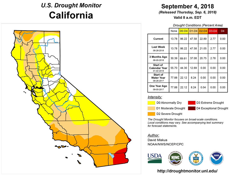
A drier than normal Water Year during the cold season (October 2017-April 2018) with less mountain snow than normal in the southern two-thirds of the West (used for spring and summer snow melt runoff), combined with a very warm and exceptionally dry summer (May-August 2018), has produced numerous negative impacts. This was most notable in Oregon where the combination of a poor winter snowpack and a hot and dry summer have produced widespread poor pasture and range conditions and very low stream flows and livestock ponds, and required water hauling, supplemental hay, and delayed forest harvesting, along with reduced livestock herds. The 4-month (May-Aug) SPEI, which takes into account temperatures and evapotranspiration with the precipitation, was below -1.5 in western Washington and Oregon by the end of August, and also in parts of eastern Oregon, northern Washington, and northern California. But since the cold season WY (Oct-Apr) was wetter and snowier in Washington and northeastern Oregon, most of the expanded D2 and D3 was added to areas with both a poor 4-month (summer) and 11-month (Oct-Aug) SPEI, namely central Oregon. Based upon the SPEI, D1 was also expanded in northwestern Washington, and D2 increased into southwestern Washington, southeastern Oregon, extreme northern California, northwestern Utah, and extreme northern Idaho where very low stream flows were occurring in the latter area. In contrast, some isolated heavy rains in southeastern Arizona (Graham County) slightly improved D2 to D1 where a short-term surplus existed.
Alaska, Hawaii, and Puerto Rico
After a reassessment of the rains from Hurricane Lane (Aug. 22-26) and any impacts in Hawaii, it appeared as though the windward sides of the islands received the huge majority of the rains, including 51.53 inches at Mountain View and 36.76 inches at Hilo on the Big Island, and 24.71 inches at West Wailuaiki on Maui. The leeward sides, unfortunately, received much less rain, with many sites recording under an inch of rain, thus no changes were made to the leeward sides of the Big Island and Maui. In contrast, Molokai received 1-4 inches of rain, and conditions were improved by 1-category. Some of the D0 was also trimmed on the islands as it was closest to the windward-leeward boundary.
In Puerto Rico, a fairly widespread showery (2-4 inches) week , plus declining deficits at 30-, 60-, 90- and 180-days, halted any further degradation and was actually enough to remove D0 in the west-central interior, north-central coast, and in the extreme northeastern section of the island.
In Alaska, the small area of D0 and D1 was left untouched as light to moderate weekly totals (1-3 inches), were not large enough to remove longer-term deficits, but not small enough for deterioration.
Looking Ahead
For the ensuing 5 days (September 6-10), heavy rain is expected from the southern Plains northeastward into the mid-Atlantic, with the Midwest drought area once again targeted for additional copious rainfall. Most of Texas and Oklahoma should also see substantial totals, as should the Ohio Valley and mid-Atlantic. Moisture from the remnants of Tropical Storm Gordon will contribute to some of these large precipitation amounts. Most of the West, northern Rockies and Plains, parts of the interior Southeast, and coastal New England are forecast to get little or no rain. 5-day temperatures should average below-normal in the Nation’s midsection where the rain is expected, while above-normal readings return to the West.
For the CPC 6-10 day extended range outlook (Sep. 11-15), the odds favor above normal precipitation along the Gulf and Atlantic Coast States, the Pacific Northwest, northern Plains, and upper Midwest. In contrast, subnormal rainfall is likely in the central U.S. and western Great Lakes region which should be welcome after heavy rains that have fallen and are expect to occur in the next 5 days. The southern half of Alaska is favored for subnormal precipitation. Most of the Nation from the Rockies eastward (and Alaska) should see above-normal temperature, with odds for subnormal readings limited to the Northwest, Texas, and eastern Alaska.
Author(s):
David Miskus, NOAA/NWS/NCEP/CPC
Dryness Categories
D0 Abnormally Dry—used for areas showing dryness but not yet in drought, or for areas recovering from drought.
Drought Intensity Categories
D1 Moderate Drought
D2 Severe Drought
D3 Extreme Drought
D4 Exceptional Drought
Drought or Dryness Types
S Short-Term, typically less than 6 months (e.g. agricultural, grasslands)
L Long-Term, typically greater than 6 months (e.g. hydrologic, ecologic)
Source: National Drought Mitigation Center
