


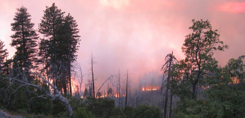
Willow Fire in Madera County near Bass Lake
Credit: InciWeb
Sierra Sun Times Public Safety Scanner
Willow Fire in Madera County Near Bass Lake
Update: Tuesday 9:30 P.M.
1,739 Acres, heavy brush and timber, 30% Contained
Willow Fire Tuesday Air Quality Report for the Foothills Including Mariposa, North Fork, Oakhurst and Yosemite
Road Closures:
Willow Canyon Rd and Central Camp Rd are closed at Hwy 274.
Beasore Rd is closed at Central camp Rd.
Autumn Ridge Rd is closed at Hwy 223.
Douglas Station Rd is closed at Trails End.
All road closures are until further notice.
Incident Overview
Fire crews will continue to build containment lines on all sides of the fire using direct and indirect strategies. The fire is in steep and rugged terrain, which requires hand crews hiking in and being supported by helicopters and air tankers. Due to the topography on the southern edge, dead and woody debris and a concentration of tree snags, crews are utilizing an indirect approach.Today the expected high pressure system has moved into the area bringing much warmer temperatures to the fire area. Monsoonal moisture may produce dry thunderstorms turning wet Friday and Saturday.
As the Willow Fire continues to burn, smoke will be impacting local communities. Smoke is typically greater in the morning and evening hours. Plan outdoor activities for times and places with low smoke levels. Up-slope breezes occur during the day, which will often take smoke into higher elevations. In the evening, these winds change direction and bring smoke back down slope to lower elevations.
A Willow Fire information phone number has been established for further information about the fire. That number is (559) 877-7449.
Evacuations
- The Central Camp area was evacuated due to the fire.
- The American Red Cross has set up an evacuation center and is located at the Oakhurst Community Center, 39800 Road 425 B in Oakhurst, CA.
Closures
-Gagges, Whiskers, and Whiskey Falls campgrounds are closed. All roads from 227 to these campgrounds are closed.
Equipment
Engines 71
Hand Crews 21
Dozers 16
Water Tenders 23
Helicopters 8
Tankers available 5
Basic Information
| Current as of | 7/28/2015, 9:30:15 PM |
|---|---|
| Incident Type | Wildfire |
| Cause | Under Investigation |
| Date of Origin | Saturday July 25th, 2015 approx. 02:30 PM |
| Location | NE of North Fork, CA |
| Incident Commander | David Cooper SCSIIMT |
| Incident Description | Wildfire |
Current Situation
| Total Personnel | 1,487 |
|---|---|
| Size | 1,739 Acres |
| Percent of Perimeter Contained | 30% |
| Fuels Involved | Timber, Chaparral, Tall grass. |
Outlook
| Planned Actions | Fire crews will continue to build containment lines on all sides of the fire using direct and indirect strategies. The fire is in steep and rugged terrain, which requires hand crews hiking in and being supported by helicopters and air tankers. Crew will begin mop up where safe to do so. |
|---|---|
| Remarks | The Willow Fire is located on the northern edge of the 2001 footprint of the North Fork Fire. As the fire moves into this previously burned area, resistance to control increases due to heavy brush and dead woody materials. Firefighting strategy includes both direct and indirect approaches. Aircraft are being utilized to keep the southern flank in check to support crews with direct attack of the fire. |
Current Weather
| Weather Concerns | Beginning today, the high pressure ridge will bring much warmer temperatures to the fire area. Localized down canyon winds in the Willow Creek Drainage may push the fire at night. Anticipated monsoonal moisture may produce dry thunderstorms beginning Thursday turning wet Friday and Saturday |
|---|
Update: Tuesday 6:32 P.M.
1,739 Acres, heavy brush and timber, 30% Contained
South Central Sierra Interagency IMT (Cooper) is in command
Evacuations remain unchanged
A community meeting is planned for tonight at 1900 hours
Update: Tuesday 1:40 P.M.
Due to the topography on the southern edge, dead and woody debris and a concentration of tree snags, crews are utilizing an indirect approach.
Today the expected high pressure system has moved into the area bringing much warmer temperatures to the fire area. Monsoonal moisture may produce dry thunderstorms turning wet Friday and Saturday.
Equipment
Engines 71
Hand Crews 21
Dozers 16
Water Tenders 23
Helicopters 8
Tankers available 5
And
United States Forest Service Law Enforcement Investigators Identify Cause of Willow Fire in Madera County near Bass Lake
Update: Tuesday 10:18 A.M.
Click Here for the Willow Fire Map in Madera County Near Bass Lake for July 28, 2015
Update: Tuesday 9:45 A.M.
A community meeting is scheduled for tonight at 7:00 P.M., North Fork Town Hall, 33060 Rd 228 North Fork, CA.
Incident personnel from the Willow Fire will be hosting the community meeting.
Incident Managers will be talking about current and expected fire behavior, evacuation status and addressing other concerns the community may have due to the Willow Fire.
Representatives from the Incident Management Team, Sierra National Forest, Cal-Fire, and Madera County Sheriff’s Department will be present to answer questions from the public.
Update: Tuesday 8:37 A.M.
1,739 Acres, heavy brush and timber, 5% Contained
Incident Overview
Fire crews will continue to build containment lines on all sides of the fire using direct and indirect strategies. The fire is in steep and rugged terrain, which requires hand crews hiking in and being supported by helicopters and air tankers. A strong high pressure system is expected to move into the area starting Monday. High temperatures are expected over the fire area over the next few days associated with the weather system.As the Willow Fire continues to burn, smoke will be impacting local communities. Smoke is typically greater in the morning and evening hours. Plan outdoor activities for times and places with low smoke levels. Up-slope breezes occur during the day, which will often take smoke into higher elevations. In the evening, these winds change direction and bring smoke back down slope to lower elevations. For more information about smoke impacts, please visit the San Joaquin Valley Air Pollution Districts website at:http://valleyair.org/wildfires.htm
The South Central Sierra Interagency Incident Management Team officially took over command Monday evening. A Willow Fire information phone number has been established for further information about the fire. That number is (559) 877-7449.
Evacuations
- The Central Camp area was evacuated due to the fire.
- The American Red Cross has set up an evacuation center and is located at the Oakhurst Community Center, 39800 Road 425 B in Oakhurst, CA.
Closures
-Gagges, Whiskers, and Whiskey Falls campgrounds are closed. All roads from 227 to these campgrounds are closed.
Basic Information
| Current as of | 7/28/2015, 8:37:35 AM |
|---|---|
| Incident Type | Wildfire |
| Cause | Under Investigation |
| Date of Origin | Saturday July 25th, 2015 approx. 02:30 PM |
| Location | NE of North Fork, CA |
| Incident Commander | David Cooper SCSIIMT |
| Incident Description | Wildfire |
Current Situation
| Total Personnel | 1,215 |
|---|---|
| Size | 1,739 Acres |
| Percent of Perimeter Contained | 5% |
| Fuels Involved | Timber, Chaparral, Tall grass. |
Outlook
| Planned Actions | Fire crews will continue to build containment lines on all sides of the fire using direct and indirect strategies. The fire is in steep and rugged terrain, which requires hand crews hiking in and being supported by helicopters and air tankers. Crew will begin mop up where safe to do so. |
|---|---|
| Remarks | The Willow Fire is located on the northern edge of the 2001 footprint of the North Fork Fire. As the fire moves into this previously burned area, resistance to control increases due to heavy brush and dead woody materials. Firefighting strategy includes both direct and indirect approaches. Aircraft are being utilized to keep the southern flank in check to support crews with direct attack of the fire. |
Current Weather
| Weather Concerns | Beginning today, the high pressure ridge will bring much warmer temperatures to the fire area. Localized down canyon winds in the Willow Creek Drainage may push the fire at night. Anticipated monsoonal moisture may produce dry thunderstorms beginning Thursday turning wet Friday and Saturday |
|---|
Update: Tuesday 8:03 A.M.
1,739 Acres, heavy brush and timber, 5% Contained
South Central Sierra Interagency IMT (Cooper) is in command.
Evacuations remain unchanged.
Smoke continues to impact Mammoth, Inyo County and the San Joaquin Valley.
Update: Tuesday 7:14 A.M.
1,739 acres and remains at 5% containment.
Update: Monday 7:54 P.M.
Total Personnel 1,215
1,521 Acres, heavy brush and timber, 5% Contained
Incident Overview
Fire crews will continue to build containment lines on all sides of the fire using direct and indirect strategies. The fire is in steep and rugged terrain, which requires hand crews hiking in and being supported by helicopters and air tankers. A strong high pressure system is expected to move into the area starting today. High temperatures are expected over the fire area over the next few days associated with the weather system.As the Willow Fire continues to burn, smoke will be impacting local communities. Smoke is typically greater in the morning and evening hours. Plan outdoor activities for times and places with low smoke levels. Up-slope breezes occur during the day, which will often take smoke into higher elevations. In the evening, these winds change direction and bring smoke down slope to lower elevations. For more information about smoke impacts, please visit the San Joaquin Valley Air Pollution Districts website at:http://valleyair.org/wildfires.htm
The South Central Sierra Interagency Incident Management Team officially took over command yesterday evening. A Willow Fire information phone number has been established for further infromation about the fire. That number is (559) 877-7449.
Evacuations
- The Central Camp area was evacuated due to the fire.
-The American Red Cross has set up an evacuation center and is located at the Oakhurst Community Center, 39800 Road 425 B in Oakhurst, CA.
Closures
-Gagges, Whiskers, and Whiskey Falls campgrounds are closed.
All roads from 227 to these campgrounds are closed.
Basic Information
| Current as of | 7/27/2015, 7:54:22 PM |
|---|---|
| Incident Type | Wildfire |
| Cause | Under Investigation |
| Date of Origin | Saturday July 25th, 2015 approx. 02:30 PM |
| Location | NE of North Fork, CA |
| Incident Commander | David Cooper SCSIIMT |
| Incident Description | Wildfire |
Current Situation
| Total Personnel | 1,215 |
|---|---|
| Size | 1,521 Acres |
| Percent of Perimeter Contained | 5% |
| Fuels Involved | Timber, Chaparral, Tall grass. |
Outlook
| Planned Actions | Fire crews will continue to build containment lines on all sides of the fire using direct and indirect strategies. The fire is in steep and rugged terrain, which requires hand crews hiking in and being supported by helicopters and air tankers. Crew will begin mop up where safe to do so. |
|---|
Current Weather
| Weather Concerns | A strong high pressure ridge is expected in the area of the fire Tuesday, which will bring much warmer temperatures. Localized down canyon winds in the Willow Creek Drainage will push the fire at night. |
|---|

