


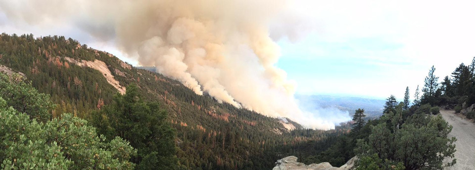
Willow Fire in Madera County near Bass Lake
Photo credit: InciWeb
Sierra Sun Times Public Safety Scanner
Willow Fire in Madera County Near Bass Lake
Update: Wednesday 6:58 P.M.
Total Personnel 1,545
2,077 Acres, heavy brush and timber, 30% Contained
Incident Overview
The Willow Fire is located on the northern edge of the North Fork Fire Footprint from 2001 and is in steep and rugged terrain which requires hand crews to hike into the area and be supported by helicopters and air tankers. The southern edge of the fire is established in the previously burned area and resistance to control along the flanks increases. This is due to the concentrations of brush and larger dead timber debris, intermingled with a concentration of tree snags.Direct attack on the southern flank is no longer feasible as it has become unsafe for firefighters and there is a low probability of success. Crews have initiated firing along the southeast edge of the fire to prevent it from out flanking them and maintaining safety. Further south a contingency line from the 2001 North Fork Fire has now become the primary control line to protect the community of Cascadel Woods. Due to this CALFIRE has now entered into Unified Command with the USFS.
On the northern flank the fire pushed through a large granite face known locally as 7-Rock. Crews will continue to scout the previously constructed fuel breaks and road systems on the northern edge with a potential for use as other contingency lines.
The use of aircraft, both helicopters and tankers continue to be used to support ground crews. A portable retardant plant was established today to enhance the effectiveness of air resources and reduce the turnaround time of helicopters.
The expected high pressure system moved over the fire area bringing much warmer temperatures. Monsoonal moisture may produce dry thunderstorms Thursday turning wet Friday and Saturday.
As the Willow Fire continues to burn, smoke will be impacting local communities. Smoke is typically greater in the morning and evening hours. Plan outdoor activities for times and places with low smoke levels. Up-slope breezes occur during the day, which will often take smoke into higher elevations. In the evening, these winds change direction and bring smoke back down slope to lower elevations.
A Willow Fire information phone number has been established for further information about the fire. That number is (559) 877-7449. Please be patient as we are receiving a large volume of calls.
Evacuations
- The Central Camp area and Douglas Ranger Station Rd was evacuated due to the fire.
- The American Red Cross has set up an evacuation center which is located at the Oakhurst Community Center, 39800 Road 425 B in Oakhurst, CA.
Closures
Campgrounds - Gagges, Whiskers, and Whiskey Falls are closed.
Willow Canyon Rd is closed. Central Camp Rd is closed. Autumn Ridge Rd (8S09) is closed. Douglas Ranger Station Rd is closed at Trails End.
Equipment
Engines 116
Hand Crews 36
Dozers 14
Water Tenders 22
Helicopters 9
Tankers available on request 4
Basic Information
| Current as of | 7/29/2015, 6:58:55 PM |
|---|---|
| Incident Type | Wildfire |
| Cause | Human |
| Date of Origin | Saturday July 25th, 2015 approx. 02:30 PM |
| Location | NE of North Fork, CA |
| Incident Commander | David Cooper SCSIIMT |
| Incident Description | Wildfire |
Current Situation
| Total Personnel | 1,545 |
|---|---|
| Size | 2,077 Acres |
| Percent of Perimeter Contained | 30% |
| Fuels Involved | Timber, Chaparral, Tall grass. |
Outlook
| Planned Actions | Fire crews will continue to build containment lines on all sides of the fire using direct and indirect strategies. The fire is in steep and rugged terrain, which requires hand crews hiking in and being supported by helicopters and air tankers. Crew will begin mop up where safe to do so. |
|---|---|
| Remarks | The Willow Fire is located on the northern edge of the 2001 footprint of the North Fork Fire. The fire is now burning well into this area and resistance to control increases due to heavy brush and dead woody materials. A direct firefighting strategy on the southern edge is no longer feasible due to the low probability of success and being unsafe for firefighters. Along the northern flank the fire continued to move through an area known locally as the 7 Rock. Aircraft are being utilized to support crews working on the ground. A portable retardant plant was established today which will reduce the time taken to to return to the firelines. |
Current Weather
| Weather Concerns | The high pressure ridge is in place over the region which is bringing much warmer temperatures to the fire area. Localized down canyon winds in the Willow Creek Drainage may push the fire at night. Anticipated monsoonal moisture may produce dry thunderstorms beginning Thursday turning wet Friday and Saturday |
|---|
Update: Wednesday 6:30 P.M.
2,077 Acres, heavy brush and timber, 30% Contained
South Central Sierra Interagency IMT (Cooper) is in command
Evacuations remain unchanged.
Evacuation advisory reissued to residents of Cascadel Woods.
Additional road closures are in effect due to the fire’s progression today.
Update: Wednesday 11:33 A.M.
Road Closures Update
Willow Canyon Rd is closed. Central Camp Rd is closed. Autumn Ridge Rd (8S09) is closed. Douglas Ranger Station Rd is closed at Trails End.
Update: Wednesday 8:17 A.M.
2,077 Acres, heavy brush and timber, 30% Contained
Incident Overview
The Willow Fire is located on the northern edge of the North Fork Fire Footprint from 2001 and is in steep and rugged terrain. This requires hand crews to hike into the area and be supported by helicopters and air tankers. As the fire continues to move into this previously burned area, the resistance to control along the flanks increase. This is due to the concentrations of brush and larger dead timber debris, intermingled with a concentration of tree snags.Firefighting strategy on the southern flank continues be direct. Crews work directly on the fires edge where safe to do so to prevent the fire from moving further south towards the communities of South Fork and Cascadel Woods. Further south a contingency line from the 2001 North Fork Fire is being opened up and utilized in the same manner to protect those communities.
Fire crews continue to build direct lines on the north flank in an attempt to tie in to the road system at the top of the ridge on the east side of the fire. Previously constructed fuel breaks on the northern edge are being scouted with a potential to use this as another contingency line.
The use of aircraft, both helicopters and tankers continue to be used to support ground crews in their efforts of direct attack. A portable retardant plant will be utilized to enhance the effectiveness of air resources and reduce the turnaround time of helicopters.
Today the expected high pressure system has moved into the area bringing much warmer temperatures to the fire area. Monsoonal moisture may produce dry thunderstorms Thursday turning wet Friday and Saturday.
As the Willow Fire continues to burn, smoke will be impacting local communities. Smoke is typically greater in the morning and evening hours. Plan outdoor activities for times and places with low smoke levels. Up-slope breezes occur during the day, which will often take smoke into higher elevations. In the evening, these winds change direction and bring smoke back down slope to lower elevations.
A Willow Fire information phone number has been established for further information about the fire. That number is (559) 877-7449.
Update: Wednesday 7:04 A.M.
2,077 Acres, heavy brush and timber, 30% Contained
Incident Overview
Fire crews will continue to build containment lines on all sides of the fire using direct and indirect strategies. The fire is in steep and rugged terrain, which requires hand crews hiking in and being supported by helicopters and air tankers. Due to the topography on the southern edge, dead and woody debris and a concentration of tree snags, crews are utilizing an indirect approach.Today the expected high pressure system has moved into the area bringing much warmer temperatures to the fire area. Monsoonal moisture may produce dry thunderstorms turning wet Friday and Saturday.
As the Willow Fire continues to burn, smoke will be impacting local communities. Smoke is typically greater in the morning and evening hours. Plan outdoor activities for times and places with low smoke levels. Up-slope breezes occur during the day, which will often take smoke into higher elevations. In the evening, these winds change direction and bring smoke back down slope to lower elevations.
A Willow Fire information phone number has been established for further information about the fire. That number is (559) 877-7449.
Evacuations
- The Central Camp area was evacuated due to the fire.
- The American Red Cross has set up an evacuation center and is located at the Oakhurst Community Center, 39800 Road 425 B in Oakhurst, CA.
Closures
-Gagges, Whiskers, and Whiskey Falls campgrounds are closed. All roads from 227 to these campgrounds are closed.
Equipment
Engines 71
Hand Crews 21
Dozers 16
Water Tenders 23
Helicopters 8
Tankers available 5
Basic Information
| Current as of | 7/29/2015, 6:52:55 AM |
|---|---|
| Incident Type | Wildfire |
| Cause | Under Investigation |
| Date of Origin | Saturday July 25th, 2015 approx. 02:30 PM |
| Location | NE of North Fork, CA |
| Incident Commander | David Cooper SCSIIMT |
| Incident Description | Wildfire |
Current Situation
| Total Personnel | 1,487 |
|---|---|
| Size | 2,077 Acres |
| Percent of Perimeter Contained | 30% |
| Fuels Involved | Timber, Chaparral, Tall grass. |
Outlook
| Planned Actions | Fire crews will continue to build containment lines on all sides of the fire using direct and indirect strategies. The fire is in steep and rugged terrain, which requires hand crews hiking in and being supported by helicopters and air tankers. Crew will begin mop up where safe to do so. |
|---|---|
| Remarks | The Willow Fire is located on the northern edge of the 2001 footprint of the North Fork Fire. As the fire moves into this previously burned area, resistance to control increases due to heavy brush and dead woody materials. Firefighting strategy includes both direct and indirect approaches. Aircraft are being utilized to keep the southern flank in check to support crews with direct attack of the fire. |
Current Weather
| Weather Concerns | Beginning today, the high pressure ridge will bring much warmer temperatures to the fire area. Localized down canyon winds in the Willow Creek Drainage may push the fire at night. Anticipated monsoonal moisture may produce dry thunderstorms beginning Thursday turning wet Friday and Saturday |
|---|
Update: Tuesday 9:30 P.M.
1,739 Acres, heavy brush and timber, 30% Contained
Willow Fire Tuesday Air Quality Report for the Foothills Including Mariposa, North Fork, Oakhurst and Yosemite
Road Closures:
Willow Canyon Rd and Central Camp Rd are closed at Hwy 274.
Beasore Rd is closed at Central camp Rd.
Autumn Ridge Rd is closed at Hwy 223.
Douglas Station Rd is closed at Trails End.
All road closures are until further notice.
Incident Overview
Fire crews will continue to build containment lines on all sides of the fire using direct and indirect strategies. The fire is in steep and rugged terrain, which requires hand crews hiking in and being supported by helicopters and air tankers. Due to the topography on the southern edge, dead and woody debris and a concentration of tree snags, crews are utilizing an indirect approach.Today the expected high pressure system has moved into the area bringing much warmer temperatures to the fire area. Monsoonal moisture may produce dry thunderstorms turning wet Friday and Saturday.
As the Willow Fire continues to burn, smoke will be impacting local communities. Smoke is typically greater in the morning and evening hours. Plan outdoor activities for times and places with low smoke levels. Up-slope breezes occur during the day, which will often take smoke into higher elevations. In the evening, these winds change direction and bring smoke back down slope to lower elevations.
A Willow Fire information phone number has been established for further information about the fire. That number is (559) 877-7449.
Evacuations
- The Central Camp area was evacuated due to the fire.
- The American Red Cross has set up an evacuation center and is located at the Oakhurst Community Center, 39800 Road 425 B in Oakhurst, CA.
Closures
-Gagges, Whiskers, and Whiskey Falls campgrounds are closed. All roads from 227 to these campgrounds are closed.
Equipment
Engines 71
Hand Crews 21
Dozers 16
Water Tenders 23
Helicopters 8
Tankers available 5
Basic Information
| Current as of | 7/28/2015, 9:30:15 PM |
|---|---|
| Incident Type | Wildfire |
| Cause | Under Investigation |
| Date of Origin | Saturday July 25th, 2015 approx. 02:30 PM |
| Location | NE of North Fork, CA |
| Incident Commander | David Cooper SCSIIMT |
| Incident Description | Wildfire |
Current Situation
| Total Personnel | 1,487 |
|---|---|
| Size | 1,739 Acres |
| Percent of Perimeter Contained | 30% |
| Fuels Involved | Timber, Chaparral, Tall grass. |
Outlook
| Planned Actions | Fire crews will continue to build containment lines on all sides of the fire using direct and indirect strategies. The fire is in steep and rugged terrain, which requires hand crews hiking in and being supported by helicopters and air tankers. Crew will begin mop up where safe to do so. |
|---|---|
| Remarks | The Willow Fire is located on the northern edge of the 2001 footprint of the North Fork Fire. As the fire moves into this previously burned area, resistance to control increases due to heavy brush and dead woody materials. Firefighting strategy includes both direct and indirect approaches. Aircraft are being utilized to keep the southern flank in check to support crews with direct attack of the fire. |
Current Weather
| Weather Concerns | Beginning today, the high pressure ridge will bring much warmer temperatures to the fire area. Localized down canyon winds in the Willow Creek Drainage may push the fire at night. Anticipated monsoonal moisture may produce dry thunderstorms beginning Thursday turning wet Friday and Saturday |
|---|

