


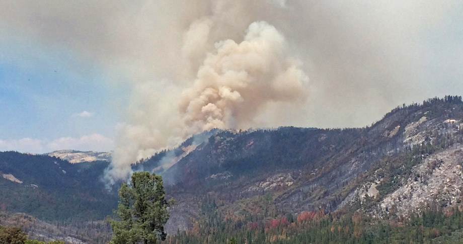
Smoke Column produced from increase burning on Div C
Willow Fire in Madera County near Bass Lake on Wednesday afternoon
Photo credit: InciWeb
Sierra Sun Times Public Safety Scanner
Willow Fire in Madera County Near Bass Lake
Update: Thursday 7:00 P.M.
3,383 Acres, heavy brush and timber, 30% Contained
South Central Sierra Interagency IMT (Cooper) is in Unified Command with CAL FIRE (Smith)
Evacuations remain unchanged.
Structure protection of Cascadel, Central Camp, and Bass Lake subdivisions.
To reduce the logistical complexities associated with travel distances the fire has been separated into two geographic and one functional branch.
An Evacuation Center has been established in Oakhurst at the Oakhurst Community Center.
Equipment
Engines 132
Hand Crews 44
Dozers 18
Water Tenders 33
Helicopters 9
Tankers available on request 4
Very Large Air Tanker 1
Total Personnel 1,900
Update: Thursday 12:17 P.M.
Updated road closure information
--Douglas Ranger Station Road
--Cascadel Road (Road 233)
--Willow Canyon Road
--8S09 from Road 233
--Central Camp Road
Update: Thursday 8:41 A.M.
Updated road closure information
--Douglas Ranger Station Road
--Beasore Road from Central Camp Road
--Cascadel Road (Road 233)
--Willow Canyon Road
--8S09 from Road 233
--Central Camp Road
And
Expanding Willow Fire in Madera County Creates A Mandatory Evacuation Order For The Cascadel Woods Community
Update: Thursday 7:00 A.M.
Very Large Air Tanker 1
Total Personnel 1,545
3,383 Acres and 30% Contained
Incident Overview
The Willow Fire is located on the northern edge of the North Fork Fire Footprint from 2001 and is in steep and rugged terrain which requires hand crews to hike into the area and be supported by helicopters and air tankers. The southern edge of the fire is established in the previously burned area and resistance to control along the flanks increases. This is due to the concentrations of brush and larger dead timber debris, intermingled with a concentration of tree snags.Direct attack on the southern flank is no longer feasible as it has become unsafe for firefighters and there is a low probability of success. Crews have initiated firing along the southeast edge of the fire to prevent it from out flanking them and maintaining safety. Further south a contingency line from the 2001 North Fork Fire has now become the primary control line to protect the community of Cascadel Woods. Due to this CALFIRE has now entered into Unified Command with the USFS.
On the northern flank the fire pushed through a large granite face known locally as 7-Rock. Crews will continue to scout the previously constructed fuel breaks and road systems on the northern edge with a potential for use as other contingency lines.
The use of aircraft, both helicopters and tankers continue to be used to support ground crews. A portable retardant plant was established today to enhance the effectiveness of air resources and reduce the turnaround time of helicopters.
The expected high pressure system moved over the fire area bringing much warmer temperatures. Monsoonal moisture may produce dry thunderstorms Thursday turning wet Friday and Saturday.
As the Willow Fire continues to burn, smoke will be impacting local communities. Smoke is typically greater in the morning and evening hours. Plan outdoor activities for times and places with low smoke levels. Up-slope breezes occur during the day, which will often take smoke into higher elevations. In the evening, these winds change direction and bring smoke back down slope to lower elevations.
A Willow Fire information phone number has been established for further information about the fire. That number is (559) 877-7449. Please be patient as we are receiving a large volume of calls.
Evacuations
- The Central Camp area and Douglas Ranger Station Rd was evacuated due to the fire.
- The American Red Cross has set up an evacuation center which is located at the Oakhurst Community Center, 39800 Road 425 B in Oakhurst, CA.
Closures
Campgrounds - Gagges, Whiskers, and Whiskey Falls are closed.
Willow Canyon Rd is closed. Central Camp Rd is closed. Autumn Ridge Rd (8S09) is closed. Douglas Ranger Station Rd is closed at Trails End.
Equipment
Engines 111
Hand Crews 36
Dozers 14
Water Tenders 22
Helicopters 9
Tankers available on request 4
Basic Information
| Current as of | 7/30/2015, 7:00:02 AM |
|---|---|
| Incident Type | Wildfire |
| Cause | Human |
| Date of Origin | Saturday July 25th, 2015 approx. 02:30 PM |
| Location | NE of North Fork, CA |
| Incident Commander | David Cooper SCSIIMT And Kevin Smith Cal-Fire |
| Incident Description | Wildfire |
Current Situation
| Total Personnel | 1,545 |
|---|---|
| Size | 3,383 Acres |
| Percent of Perimeter Contained | 30% |
| Fuels Involved | Timber, Chaparral, Tall grass. |
Outlook
| Planned Actions | Fire crews will continue to build containment lines on all sides of the fire using direct and indirect strategies. The fire is in steep and rugged terrain, which requires hand crews hiking in and being supported by helicopters and air tankers. Crew will begin mop up where safe to do so. |
|---|---|
| Remarks | The Willow Fire is located on the northern edge of the 2001 footprint of the North Fork Fire. The fire is now burning well into this area and resistance to control increases due to heavy brush and dead woody materials. A direct firefighting strategy on the southern edge is no longer feasible due to the low probability of success and being unsafe for firefighters. Along the northern flank the fire continued to move through an area known locally as the 7 Rock. Aircraft are being utilized to support crews working on the ground. A portable retardant plant was established today which will reduce the time taken to to return to the firelines. |
Current Weather
| Weather Concerns | The high pressure ridge is in place over the region which is bringing much warmer temperatures to the fire area. Localized down canyon winds in the Willow Creek Drainage may push the fire at night. Anticipated monsoonal moisture may produce dry thunderstorms beginning Thursday turning wet Friday and Saturday |
|---|
Update: Thursday 6:58 A.M.
Total Personnel 1,545
2,077 Acres, heavy brush and timber, 30% Contained
Update: Wednesday 6:58 P.M.
Total Personnel 1,545
2,077 Acres, heavy brush and timber, 30% Contained
Incident Overview
The Willow Fire is located on the northern edge of the North Fork Fire Footprint from 2001 and is in steep and rugged terrain which requires hand crews to hike into the area and be supported by helicopters and air tankers. The southern edge of the fire is established in the previously burned area and resistance to control along the flanks increases. This is due to the concentrations of brush and larger dead timber debris, intermingled with a concentration of tree snags.Direct attack on the southern flank is no longer feasible as it has become unsafe for firefighters and there is a low probability of success. Crews have initiated firing along the southeast edge of the fire to prevent it from out flanking them and maintaining safety. Further south a contingency line from the 2001 North Fork Fire has now become the primary control line to protect the community of Cascadel Woods. Due to this CALFIRE has now entered into Unified Command with the USFS.
On the northern flank the fire pushed through a large granite face known locally as 7-Rock. Crews will continue to scout the previously constructed fuel breaks and road systems on the northern edge with a potential for use as other contingency lines.
The use of aircraft, both helicopters and tankers continue to be used to support ground crews. A portable retardant plant was established today to enhance the effectiveness of air resources and reduce the turnaround time of helicopters.
The expected high pressure system moved over the fire area bringing much warmer temperatures. Monsoonal moisture may produce dry thunderstorms Thursday turning wet Friday and Saturday.
As the Willow Fire continues to burn, smoke will be impacting local communities. Smoke is typically greater in the morning and evening hours. Plan outdoor activities for times and places with low smoke levels. Up-slope breezes occur during the day, which will often take smoke into higher elevations. In the evening, these winds change direction and bring smoke back down slope to lower elevations.
A Willow Fire information phone number has been established for further information about the fire. That number is (559) 877-7449. Please be patient as we are receiving a large volume of calls.
Evacuations
- The Central Camp area and Douglas Ranger Station Rd was evacuated due to the fire.
- The American Red Cross has set up an evacuation center which is located at the Oakhurst Community Center, 39800 Road 425 B in Oakhurst, CA.
Closures
Campgrounds - Gagges, Whiskers, and Whiskey Falls are closed.
Willow Canyon Rd is closed. Central Camp Rd is closed. Autumn Ridge Rd (8S09) is closed. Douglas Ranger Station Rd is closed at Trails End.
Equipment
Engines 116
Hand Crews 36
Dozers 14
Water Tenders 22
Helicopters 9
Tankers available on request 4
Basic Information
| Current as of | 7/29/2015, 6:58:55 PM |
|---|---|
| Incident Type | Wildfire |
| Cause | Human |
| Date of Origin | Saturday July 25th, 2015 approx. 02:30 PM |
| Location | NE of North Fork, CA |
| Incident Commander | David Cooper SCSIIMT |
| Incident Description | Wildfire |
Current Situation
| Total Personnel | 1,545 |
|---|---|
| Size | 2,077 Acres |
| Percent of Perimeter Contained | 30% |
| Fuels Involved | Timber, Chaparral, Tall grass. |
Outlook
| Planned Actions | Fire crews will continue to build containment lines on all sides of the fire using direct and indirect strategies. The fire is in steep and rugged terrain, which requires hand crews hiking in and being supported by helicopters and air tankers. Crew will begin mop up where safe to do so. |
|---|---|
| Remarks | The Willow Fire is located on the northern edge of the 2001 footprint of the North Fork Fire. The fire is now burning well into this area and resistance to control increases due to heavy brush and dead woody materials. A direct firefighting strategy on the southern edge is no longer feasible due to the low probability of success and being unsafe for firefighters. Along the northern flank the fire continued to move through an area known locally as the 7 Rock. Aircraft are being utilized to support crews working on the ground. A portable retardant plant was established today which will reduce the time taken to to return to the firelines. |
Current Weather
| Weather Concerns | The high pressure ridge is in place over the region which is bringing much warmer temperatures to the fire area. Localized down canyon winds in the Willow Creek Drainage may push the fire at night. Anticipated monsoonal moisture may produce dry thunderstorms beginning Thursday turning wet Friday and Saturday |
|---|

