


California and National Drought Summary for February 2, 2016
Summary
The week following the major East Coast snowstorm/blizzard was characterized by the passage of several cold fronts across the contiguous U.S., frequently changing temperature patterns related to deamplifying flow aloft, and widespread precipitation across the Great Lakes, the Southeast and the West. By the end of the observed period (Tuesday morning, 7am Eastern time), a major storm system had developed across the Southwest and was moving across the Central states, attended by areas of heavy snow (and in some cases, blizzard conditions), heavy rain, flash flooding, and severe weather.Alaska, Hawaii, and Puerto Rico
In Hawaii, many areas received less than 20 percent of average rainfall for January. Though impacts are not that noticeable yet, they are expected to be in coming weeks, especially if the outlooks for continuing dry weather verify. The only changes this week rendered to the Hawaiian drought depiction included the expansion of D0 across eastern Molokai, and across all of Niihau. In Puerto Rico, most reservoirs show adequate water levels, while stream flows across eastern portions of the island remain low. With the dry season already well established, it was decided that status quo would be the best choice for this week. No changes were made in Alaska this week.The Far West
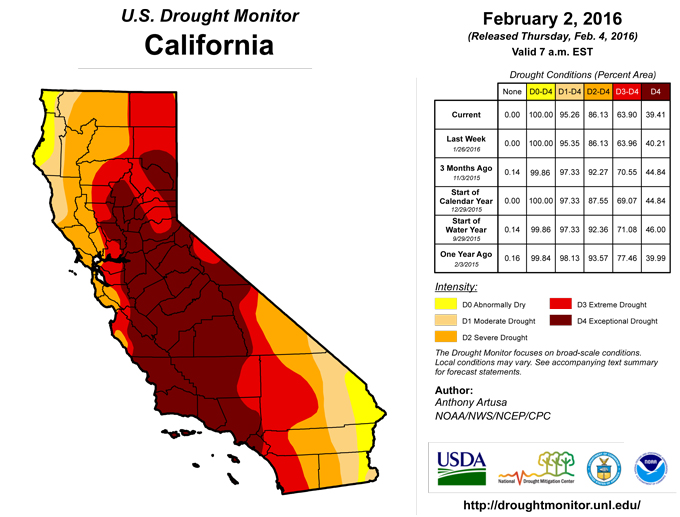
Western Washington, western Oregon, and approximately the northern half of California reported large precipitation surpluses during the past two weeks. The largest surpluses (4-8 inches or greater, liquid equivalent) were noted across the Olympic Peninsula of Washington, extreme southwestern Oregon, northwestern California, and in the northern Sierras. Viewed from a somewhat different perspective, AHPS Percent of Normal Precipitation (PNP) values ranged primarily between 150-300 percent of normal. In contrast, the coastal region of southern California had PNPs ranging between the 25th and 50th percentiles of the historical distribution.Preliminary PARS data from the USDA (through January 30th) provides an informative look at reservoir conditions for the state of California. From about Sacramento northward to the Oregon border, PARS values generally range between 70-120 percent of average, though there are values that fall outside this range. Between Sacramento and Bakersfield, PARS values generally range between 20-70 percent of average, while south of Bakersfield, there are large variations between reservoirs, in addition to a relatively small sample size, making it difficult to approximate a useful range of values.
As of February 3rd, SNOTEL basin-average Snow Water Content (SWC) values in the California Sierras range from 110-150 percent of average. SWC values in northwestern Oregon range from 25-125 percent of average, and between 125-150 percent of average in the southwestern part of the state. In western Washington, SWC values range from 90-110 percent of average.
Despite heavy rainfall in January, an above-average snowpack and rising reservoirs in many areas, the California State Water Resources Control Board recently approved an 8-month extension of existing drought-related emergency regulations. This is a reminder that although El Nino-related precipitation has been bountiful so far this winter, the drought situation in California remains very serious.
It was decided to hold off on making substantial changes to the depiction in the far West until next week, despite heavy precipitation and rebounding stream flows in the short-term (past few weeks). This is because it takes time to assess the impacts all this moisture will have on long-term deficits and other hydrological considerations. The only change made this week was in the northern Sierras of California (El Dorado County), where the coverage of exceptional drought (D4) was reduced.
The Great Plains and Upper Mississippi Valley
For the few remaining areas of drought across the Plains and Upper Mississippi Valley, precipitation for the past two weeks has been generally close to, or slightly above, normal. In Texas, January 2016 precipitation was about 62 percent of normal statewide. Consideration of various 2-6 month precipitation indicators supported the introduction of D0 to Tom Green County in west-central Texas, and the introduction of D0 to Nueces and San Patricio Counties (along the southern coast near Corpus Christi). These same precipitation indicators, and the occurrence of fairly substantial evaporation, supported the expansion of pre-existing D0 conditions across Starr and Hidalgo Counties in far southern Texas. Decent precipitation fell in western Kansas prior to the data cutoff time (12z Tuesday) from a potent storm which brought a variety of weather hazards and precipitation types to the Central states. The amount of precipitation received thus far does not appear to be enough to eliminate the residual area of D0 in west-central Kansas, though it is enough to at least offset the dry pattern experienced during the last 30-days. In Nebraska and the Dakotas, the preliminary Percent of Average Reservoir Storage (PARS) data from the U.S. Department of Agriculture (USDA), as of January 31, 2016, shows values that generally range between 90-140 percent of average. In North Dakota, lack of snow cover, and 30-day and 60-day PNP ACIS (Applied Climate Information System) maps warranted a generous expansion of D0 conditions from its current location northward to the Canadian border (as far east as Rolette County), and as far west as the Missouri River. This is also consistent with neighboring dryness/drought across the border in southeastern Saskatchewan and southern Manitoba.The Northeast, mid-Atlantic, and Great Lakes
The past 14-days have been relatively dry for the interior Northeast, with Departures from Normal Precipitation (DNP) values generally ranging from 1-2 inches below normal. DNPs in and around western Maryland, and southeastern Lower Michigan, were close to normal during this same two-week period.Several minor changes were made to the regional drought depiction this week. Abnormal dryness (D0) was expanded slightly across western Sullivan County in southeastern New York, and extended across the adjacent Pennsylvania counties of Pike and (southern) Wayne, to connect with the D0 area already present in northeastern Pennsylvania. This area missed out on the heavy snowfall accumulations from the major nor’easter of January 22-24, 2016, and the Advanced Hydrologic Prediction Service (AHPS) shows relative dryness here for at least the past 6 months. In southwestern Pennsylvania, abnormal dryness was expanded across Somerset County and the neighboring western Maryland Counties of Garrett and (western) Allegany.
The Rockies and Intermountain region
During the last 14-days, northern and central portions of both the Rockies and Intermountain region experienced near- to above-normal precipitation amounts. Southern portions of both the Rockies and Intermountain region saw near- to below-normal precipitation amounts during the same observational period. PARS data indicates that reservoirs in Montana near the Continental Divide are generally running about 60-120 percent of average, and reservoirs across the High Plains of Montana are running about 105-150 percent of average. The only change to the depiction in Montana this week was to trim the severe drought (D2) area away from the Canadian border. This was based upon several considerations. The Standardized Precipitation Index (SPI) and the Standardized Precipitation Evapo-transpiration Index (SPEI) from 1-4 months, current stream flows running close to normal, and relatively wet conditions just north of the border in neighboring parts of Alberta and British Columbia. In Wyoming, PARS values range from about 95-175 percent of average, while in Colorado, reservoirs are averaging close to normal. Significant snowfall was reported in Colorado during the past few days (many areas received a foot or more of new snow). Reassessment of conditions next week will be needed to see if the removal of existing D0 areas in Colorado is warranted.The Southeast
In southeastern Georgia, DNP’s spanning the last two weeks range from 1-2 inches below normal. The only modification to the drought depiction in Georgia was the expansion of D0 throughout all of Bryan County (near Savannah), and Effingham County. However, during the upcoming 7-day period, there are several opportunities for very significant amounts of rain (perhaps as much as 3-4 inches) to fall across this area.Author(s):
Anthony Artusa, NOAA/NWS/NCEP/CPC
Dryness Categories
D0 ... Abnormally Dry ... used for areas showing dryness but not yet in drought, or for areas recovering from drought.Drought Intensity Categories
D1 ... Moderate DroughtD2 ... Severe Drought
D3 ... Extreme Drought
D4 ... Exceptional Drought
Drought or Dryness Types
S ... Short-Term, typically <6 months (e.g. agricultural, grasslands)L ... Long-Term, typically >6 months (e.g. hydrology, ecology)
Source: National Drought Mitigation Center

