


California and National Drought Summary for May 31, 2016
Summary
June 2, 2016 - The past week’s weather brought about a mixed bag of changes to the U.S. Drought Monitor map, with expansion of dryness and/or drought noted in the Northeast, Southeast, upper Great Lakes, northern Plains and Pacific Northwest. The most notable expansions this week are the advancement of D0 across the northern Cascades in Washington up to the Canadian border and the expansion of D0-D1 and a new area of D2 in the Southeast centered over northern Georgia, northern Alabama and southern Tennessee. For the most part, unseasonably warm temperatures were found east of the Rocky Mountains (with the exception being California), particularly in the Midwest, Upper Great Lakes and Northeast, where readings ran 5-15 degrees above the norm. On the other side of the spectrum, cooler-than-normal temperatures were observed across much of the West as Mother Nature always seems to find a way to balance the scales.The Northeast
Spotty but heavy rains brought some relief to isolated areas of the D0 areas in New York and into southeastern Pennsylvania and central New Jersey as well. However, the rains missed western New York around Buffalo, eastern New Hampshire and southwestern Maine, bringing about an expansion of D0 in these areas. Above-normal temperatures (6-10 degrees plus) also spread across the entire region last week and well below normal streamflow levels are persistent over the New England states in particular as we head into the high-demand summer season.Mid-Atlantic
Dryness continues to strengthen its toehold in the western Carolinas as a slight push of D1 is noted on this week's map in North Carolina. The rest of the region remains unchanged.The Southeast
Drought is beginning to ramp up rapidly across this region during what should be their wettest time of year. Instead, the D0-D1 areas have expanded across most of eastern Tennessee, northern Georgia and northern Alabama. A new area of severe drought (D2) has also been introduced in northwest Georgia, northeast Alabama and extreme southeastern Tennessee. The lack of spring moisture has really been putting a strain on agriculture in the region, with summer heat yet to come. This year’s tropical storm season prospects will go a long way in determining how entrenched this drought becomes in the Southeast.The South
A relatively quiet seven days on the weather front results in no changes on this week’s map in Louisiana or Mississippi. In fact, some recent rains have helped stave off expansion of D0 as temperatures rise.Midwest
This week’s map brings expansion of D0 to parts of northeastern and southwestern Wisconsin, extreme northeastern Iowa and extreme southeastern Minnesota as temperatures soared to well above normal readings (5 to 10 degrees).The dryness has been around for the past 30-60 days, but cooler temperatures have kept impacts at bay for the most part. That could change quickly now with summer temperatures coming into play, and these above-normal temperatures are forecasted to persist for at least the next couple of weeks. D0 was also introduced this week in central and south-central Iowa with that dryness spilling into extreme north-central Missouri as well. On the improvement side, good rains in extreme northwestern Minnesota led to some trimming of the D0 there.The Plains
Again, heavy rains pounded eastern Texas, parts of eastern Oklahoma and eastern Kansas. Recent rains have also led to the trimming or removal D0 across western Texas and the Texas Panhandle. Farther north, recent dryness and more seasonable temperatures have led to an expansion of D0 in western South Dakota and into northeastern Wyoming. Rains in northwest North Dakota and parts of eastern North Dakota have led to the reduction of D0 there.The West
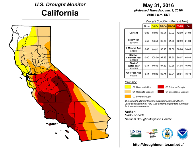
Most of the changes on this week’s map were for the better, with the one exception being the northern Cascades in Washington, which saw a push of D0 conditions north to the Canadian border. Elsewhere, D2 has been removed from the Big Horn range in Wyoming given the more favorable weather of late, but D0-D1 still remains as we head into summer. Some minor reduction of D0-D1 was also made in northwestern Montana this week, but lingering long-term water supply impacts remain. Other areas seeing changes for the better can be found along the eastern and southern flanks of the drought across western Nevada, extreme southeastern California, northwestern Arizona and southwestern Utah. Although certainly not all in the clear, northwestern California has seen some minor reduction of D0-D1.Hawaii, Alaska, and Puerto Rico
No changes were made this week in Alaska, Hawaii or Puerto Rico, so status quo rules.Looking Ahead
The NWS WPC 7-Day Quantitative Precipitation Forecast (QPF) (June 1-8, 2016) is showing a very dry week on tap west of the continental divide. Heavy rains are expected in the southern Plains, Michigan’s Upper Peninsula, southern Florida, the middle Appalachians and New England. The West will also warm up under some strong ridging as temperatures are expected to be running 6-18 degrees above normal for this time of year. Cooler weather should persist over this period in Texas, the Midwest, the Mid-Atlantic and the Northeast.Under strong model and forecast tool agreement, CPC’s 6-10 day outlooks are showing a strong ridge building in the West and extending into the central and northern Plains. Temperatures here will likely be running well above normal for the period June 7-11. Temperatures across Alaska and the Southeast also look to be above normal while the Northeast is most likely to experience below-normal temperatures during this time frame. As for precipitation, the odds are tilted toward above-normal totals in Alaska, the Pacific Northwest, the northern Great Basin and northern New England. The odds are not looking good in the central and southern Great Plains, Midwest, Gulf Coast region (except for southern Florida), and Mid-Atlantic, with rainfall looking likely to be below normal through early June.
Author(s):
Mark Svoboda, National Drought Mitigation Center
Dryness Categories
D0 ... Abnormally Dry ... used for areas showing dryness but not yet in drought, or for areas recovering from drought.Drought Intensity Categories
D1 ... Moderate DroughtD2 ... Severe Drought
D3 ... Extreme Drought
D4 ... Exceptional Drought
Drought or Dryness Types
S ... Short-Term, typically <6 months (e.g. agricultural, grasslands)L ... Long-Term, typically >6 months (e.g. hydrology, ecology)
Source: National Drought Mitigation Center
