


California and National Drought Summary for July 12, 2016
Summary
July 15, 2016 - A ridge of high pressure across the South and a trough of low pressure over the Northwest combined for an active storm track along the northern tier of the U.S. into the Midwest and southeastward into the Tennessee Valley. As numerous cold fronts tracked from the Northwest and southwestern Canada into the Nation’s mid-section and encountered the Southern ridge, they would stall and generate bands of heavy showers and thunderstorms. The week’s greatest totals fell on western and southern Kentucky, south-central North Dakota, central Minnesota, and northwestern Wisconsin where 4-8 inches (locally over 10 inches) was measured. Elsewhere, light to moderate rains occurred in the northwestern quarter of the U.S., most of the northern two-thirds of the Great Plains, upper Midwest, western Corn Belt, Tennessee Valley, portions of the Southeast, most of the Carolinas, and sections of the Northeast. Mostly dry weather enveloped the southwestern quarter of the Nation, the southern Plains, most of Florida, the Ohio Valley and eastern Great Lakes region, and mid-Atlantic. Weekly temperatures averaged below normal in the West, northern Plains, parts of the Midwest, and in New England. Positive temperature anomalies were found in the southern half of the Plains, across the Southeast, mid-Atlantic, and eastern Great Lakes region, with excessive heat (anomalies more than +6 degs F and triple-digit highs) in the southern High Plains. Precipitation decreased in Alaska as compared to last week (except in east-central sections), windward showers continued across Hawaii, and most of Puerto Rico saw light to moderate showers except for drier weather in south-central and southwestern sections of the island.New England and eastern Great Lakes region
Generally light (less than an inch) scattered showers fell across most of the region, although a few locations saw locally heavy (2-5 inches) rain; however, some areas recorded little or no rain. Temperatures averaged 2 to 6 degs F below normal in New England, and 2 to 5 degs F above normal in the eastern Great Lakes and mid-Atlantic. In areas with locally heavy rain, some slight improvement was made (eastern Upper Peninsula of Michigan, north-central lower Michigan, northeastern Pennsylvania and east-central New York, extreme northern parts of New York and New Hampshire, and west-central New Jersey). Where precipitation was light to moderate (0.5-1 inch), no changes were made. Unfortunately, some areas measured little (less than 0.25 inches) or no rain which led to further deterioration. This included most of Ohio and northern Indiana, north-central Pennsylvania, western New York, and coastal sections of New England. With the scattered rainfall, USDA/NASS statewide topsoil moisture percent short to very short ending on July 10 generally decreased (improved) a few percentage points from July 3, although Ohio, Pennsylvania, and Massachusetts increased (declined) a few percentage points this week to 47, 40, and 77%, respectively. Likewise, subsoil moisture percent short to very short fluctuated a bit, with Ohio, Pennsylvania, and Massachusetts increasing 8 points to 39, 39, and 68%, respectively. States with the highest percent of July 10 pasture and range conditions rated poor or very poor included Vermont (44), Connecticut (44), and Massachusetts (42). USGS 7-day average stream flows reached record low values on July 12 in western New York and central Massachusetts, and many indices at the 2-4 month periods were depicting D2-D4 conditions. Farmers near Syracuse, NY, reported their corn leaves curl and were irrigating heavily if they had the capacity. Similarly, farmers were irrigating in New Hampshire and Massachusetts if they could, with their strawberry crop smaller but sweeter than normal due to the dry conditions. Historically, NCEI statewide precipitation ranks for June 2016 had Massachusetts and Rhode Island with the twelfth driest June on record (since 1895), while April-June 2016 was the eleventh, thirteenth, and fourteenth driest such period in Connecticut, New York, and Massachusetts. Therefore, two new D2 areas were added in western New York where the lowest indices and largest departures were found (90-day deficits of 4-6 inches), along with a slight expansion of the existing D2 into southeastern Maine and west-central Massachusetts. D1 was slightly extended into northern Pennsylvania, added to northern and west-central Ohio, and expanded in south-central lower Michigan. D0 was increased across northern Indiana and western and central Ohio.Tennessee Valley, Southeast, and Delta
Copious rains (4-8 inches, locally to 12) fell just to the north of the main Southeastern drought area (on western and southern Kentucky), although some significant totals (2-5 inches) did occur in central Tennessee, along with scattered moderate to heavy showers and thunderstorms in parts of Mississippi, Alabama, and the southern Appalachians. As a result, a 1-category improvement was made in much of central Tennessee, with a few 2-category changes (e.g. D1 to nothing) where the heaviest rains (more than 4 inches) fell, short-term indices were normal, and most deficits were eliminated. A 1-category improvement was made where rainfall exceeded 2 inches, and this occurred in portions of extreme northern and central Mississippi, northern Alabama, eastern Tennessee, and western North Carolina. Decent showers in southern Mississippi and Alabama also erased some of the D0 there. In contrast, some areas missed out on the beneficial rains as is expected with summertime pop-up convective storms. This included portions of northern Mississippi, central Alabama, northwestern and northeastern Georgia, and western South Carolina. For the month of June, the city of Anderson, SC, measured 0.63 inches (normal is 3.81 inches), or the fourth driest June on record. At Chattanooga, TN, only 0.29 inches fell from June 6-July 4 (normal June is 4.05 inches). During the past 90-days, there were pockets where less than half of normal precipitation (with deficits of 8-12 inches) had fallen, and they were highlighted with D2 or D3. USGS stream flows were also in the lower tenth percentile (much below normal) in much of the D2-D3 areas, especially at longer time periods (14- and 28-days) as recent rains have temporarily increased flows. In the Southeast, July 10 USDA/NASS statewide percent of topsoil moisture rated short to very short that worsened or remained unchanged this week included Georgia (60), Alabama (55), and South Carolina (47). Corresponding subsoil moisture levels included Georgia (49), Alabama (54), and South Carolina (37). About one-third of the pastures in Georgia and South Carolina were rated poor or very poor, although most major crops were rated fair or better. In addition, areas farther to the west (Arkansas and Louisiana) and south (Florida) have experienced short-term abnormal dryness at 30- and 60-days (exacerbated by periods of above-normal temperatures), leading to increased topsoil moisture shortages (Arkansas 58%, Louisiana 48%, Florida 31%). Accordingly, D0 was added to southwestern Georgia, north-central Florida, south-central Louisiana, northwestern Louisiana, southwestern Arkansas, western Tennessee, and the extreme southern part of the Missouri Bootheel.Midwest
An extremely wet week hit the northern Plains and upper Midwest, with Minnesota experiencing their largest flash flood event in the state since June 2012. More than 6 inches of rain fell during the 24-hour period ending 12 UTC July 12 (Day 7 for the DM period) across central Minnesota into northwestern Wisconsin. However, it also rained several other days during the week, with widespread storms and generous amounts of rain occurring in the northern Plains, upper Midwest, western Corn Belt, and southward into the Tennessee Valley. Not surprisingly, a 1-category improvement was made to the D0-D2 area of western Minnesota, northeastern South Dakota, and southeastern North Dakota. A 2-category improvement could have been made with the excessive rainfall except that the dryness had stretched back to 6-months or longer, creating rather large shortages that this week’s rain did not erase. For example, Wheaton, MN, recorded 6.32 inches of precipitation during January 1-June 30 (normal = 11.81 inches). During this week, 4.51 inches fell (July 1-31 normal = 3.20 inches), so not all of the 6-month deficit was recovered. The recently added D0 in east-central Minnesota was mostly removed except for the southern portion where less than 2 inches fell, and small 60- and 90-day deficiencies remained. Farther south, over 2 inches of rain was enough to eliminate D0 from parts of eastern Nebraska and western Iowa, but the larger D0-D1 area in southern Iowa and northeastern Missouri stayed as the rains were not enough to significantly eliminate 90-day deficits or greatly improve 3-month SPIs except in a few locations; however, another week or two of similar rains should be enough for improvement. Across central Missouri, pockets of heavier rain eliminated parts of the D0. Lighter amounts (less than an inch) also fell on the western and central Great Lakes region, central Corn Belt, and parts of the lower Missouri Valley, leaving conditions unchanged. In contrast, a few parts of the Midwest missed out on the moisture, namely southern Nebraska, southern Wisconsin, and the eastern Corn Belt (Indiana, Ohio, southern lower Michigan). The eastern Corn Belt was discussed in the New England and eastern Great Lakes section, but southeastern Wisconsin has been dry enough the past 2-3 months that D0 was added.Plains
Several storm systems from the Pacific Northwest and southwestern Canada dropped moderate to heavy rain (1-5 inches, locally 8 inches) on Montana, North Dakota, and parts of South Dakota, providing a 1-category improvement where the totals exceeded 2 inches. While much of the heaviest rain fell on non-drought areas of the Dakotas, some D0 and D1 were improved in southwestern North Dakota (Morton, Grant, and Sioux counties) and northwestern South Dakota (Corson and northeastern Perkins counties). Farther east, a general 1-category improvement was made in southeastern North Dakota and northeastern South Dakota (see Midwest summary) where 2-5 inches fell. In contrast, less rain fell in northwestern South Dakota and extreme southwestern North Dakota (Bowman and Slope counties), and with reports of low yield and alfalfa harvests rivaling 1988, near-record June warmth, and poor VegDri values, some deterioration was made. D2 was extended northward into western Harding County, SD, and D1 was pushed northward into western Slope County, ND. In the central Plains, showers were more scattered in nature, with the few small D0 and D1 areas generally unchanged except for the removal of D0 in eastern Nebraska (see Midwest summary). In the southern Plains, scattered decent rainfall was limited to southwestern Texas, north of Midland, TX (Martin, Howard, Borden, and Dawson counties), and northeastward into central Oklahoma. Hot weather, however, overspread much of the southern Plains with temperatures averaging 6 to 9 degs F above normal and triple-digit highs. Where the rains missed and short-term (at 30- and 60-days) deficiencies have developed, small D0 areas were added in the Texas Panhandle, northeastern Texas, and south of Beeville, TX (Live Oak and San Patricio counties). Similarly in Oklahoma, D0 and D1 was expanded where the rains missed and shortNorthwest and Northern Rockies
After last week’s addition of D1 along the Oregon coast due to unseasonably dry and occasionally warm weather since April, this week brought unseasonably cool and wet weather to the entire region. In fact, it was cold enough for accumulating snow to fall in central Idaho north of McCall at an elevation of 6,000-7,000 feet. With precipitation amounts of 0.5-2 inches along the coast and in the northern Cascades and parts of the northern Rockies, it was almost enough to make improvements in parts of the region, however, since the past 3-4 months were quite dry and warm and some drought impacts had already commenced (e.g. northeastern Oregon), this event was not enough for any improvements west of the Rockies. In the northern Rockies and eastward, however, enough precipitation (2-3 inches) fell to remove D0 in northwestern Montana (Lake County) and 1.5-2 inches in northern Musselshell and northern Golden Valley Counties in central Montana. In eastern Idaho, D0 was reassessed, with the northern portion removed per 0.5 inches of precipitation and good water supplies while D0 was shifted southward into the headwaters of the Snake River where less precipitation fell and most indicators are showing moisture shortages. In northern Colorado (central Rockies), D0 was expanded into Larimer, Boulder, and Gilpin counties due to recent dryness, 6-month SPIs 0 to -1.5, and the VegDri showing some stressed vegetation. Western Boulder County saw a wild fire start last week aided by the hot, dry, and windy weather.California and the Great Basin
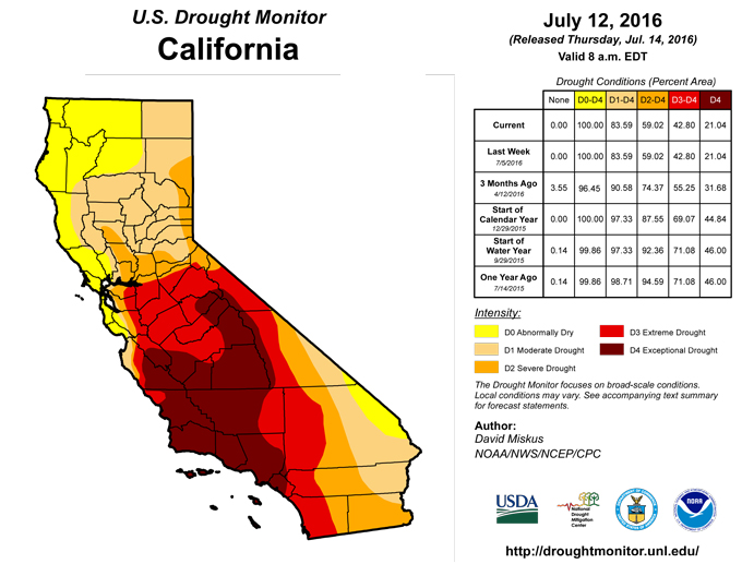
The normally dry summer months in this region lived up to its billing as no precipitation fell across the entire area except for light amounts (0.1-0.5 inches) in far northern locales. Temperatures generally averaged below normal for the week, providing some relief for containment of new wild fires thanks to lower readings and higher humidity. As to be expected during the summertime, status-quo is most-likely for the next few months - unless the monsoon changes its trajectory – and even that may not be enough for any improvement depending on temperatures.Southwest
After a promising start to the monsoon last week in the Four Corners states, shower activity abruptly stopped across most areas as dry and warm weather prevailed. In fact, weekly temperatures averaged 6-8 degs F above normal with triple-digit highs in eastern New Mexico and west Texas, but gradually decreased to subnormal readings in far western areas. Light, scattered rains (less than 0.5 inches) were confined to extreme southeastern Arizona and parts of New Mexico, with heavier amounts (0.5-2 inches) in southwestern Texas. The rains were enough near El Paso, TX, to remove a bit of the D0 there. Since the previous week was generally wet and short-term indices are actually near or above normal (wet) due to low late spring and early summer normal precipitation totals, no changes were made.Alaska, Hawaii, and Puerto Rico
In Hawaii, generally light to occasionally moderate windward showers continued across the islands while most leeward locations remained seasonably dry. The one exception to this is the leeward side of the Big Island that normally has a summer maximum, and recent rains have fallen on this region, gradually improving conditions. As a result, the small D3 area in west-central Big Island was removed, but the remaining small D3 area near South Point on the Big Island has not seen enough improvement yet. Elsewhere, no changes were made.In Alaska, last week’s wet weather in the interior decreased somewhat, but moderate to heavy rains (1-3 inches) continued in east-central locations. Much of the existing D0 in northwestern Alaska only saw 0.1-0.6 inches of rain, not enough for improvement but enough to keep D1 at bay. The southeastern Panhandle was dry this week and at 60-days, but June 30-July 2 rains plus a wet spell during early May has been enough to postpone any D0 development there.
In Puerto Rico, scattered showers dropped varying amounts of rain across the island (1-2 inches on the northeast, 4-10 inches on the northwest), but mainly missed the southwestern and south-central sections of the island. The latter area included the existing D0-D1 area, and out to 90-days, rainfall has been about half of normal. With 3-month deficits of 6-12 inches, D1 was expanded slightly northward over the area with the greatest shortages. Elsewhere, enough rain fell to keep conditions status-quo.
Looking Ahead
During the next 5 days (July 14-18), light to moderate precipitation (0.75-1.5 inches) is expected across much of the northern and central Plains, Midwest, Tennessee Valley, southern Appalachians, Carolinas, southern Louisiana and Florida, and the Northeast, with the largest totals (2-3.5 inches) in the south-central Plains, southern Appalachians, and North Carolina. Little or no rain is forecast for much of the Far West, Rockies, southern Plains, and coastal New England. Temperatures should average above normal in the Southwest and southern High Plains, Deep South, and in the Atlantic Coast States, with subnormal readings in the Northwest, northern Plains, and Midwest.The NWS 6- to 10-day outlook for July 19-23 favors sub-median precipitation for much of the lower 48 States (West, northern Rockies, Plains, Midwest, southern Alaska), except for odds tilted toward above-median rainfall in northern Alaska, the Southwest, and small areas of the Pacific Northwest, southern Texas and Florida, and eastern Carolinas. The chances for above normal temperatures are high in southern Alaska and across much of the contiguous U.S., especially in the North Central States. Exceptions to this include eastern Alaska and the Pacific Northwest where subnormal readings are likely.
Author(s):
David Miskus, NOAA/NWS/NCEP/CPC
Dryness Categories
D0 ... Abnormally Dry ... used for areas showing dryness but not yet in drought, or for areas recovering from drought.Drought Intensity Categories
D1 ... Moderate DroughtD2 ... Severe Drought
D3 ... Extreme Drought
D4 ... Exceptional Drought
Drought or Dryness Types
S ... Short-Term, typically <6 months (e.g. agricultural, grasslands)L ... Long-Term, typically >6 months (e.g. hydrology, ecology)
Source: National Drought Mitigation Center

