


California and National Drought Summary for October 18, 2016
Summary
October 20, 2016 - Dry, hot conditions across the central and southern U.S. contrasted with heavy rain and mountain snow in the northwestern quarter of the nation. As a result, drought continued to rapidly intensify from the Delta to the Southeast, with drought intensification also noted over portions of the Northeast. Conversely, large swaths of drought were reduced or eliminated from the northern Rockies into the Pacific Northwest.Mid-Atlantic and Northeast
Ongoing dryness coupled with unseasonably high temperatures necessitated expansion of Abnormal Dryness (D0) and varying degrees of drought from northern Maryland into western New England. Temperatures for the week averaged 3 to 10°F above normal, with daytime highs approaching or topping 80°F for much of the week across southern portions of the region. Precipitation during the period was light (mostly less than half an inch) and confined to locales west of the mountains. In the expanded Severe Drought (D2) area of Vermont and New Hampshire, rainfall over the past 3 months has totaled a meager 40 to 60 percent of normal, with most streamflows in the lowest 5th percentile. In Maine, Moderate Drought (D1) was likewise expanded north to reflect unfavorably dry conditions over the past 2 months (30-50 percent of normal). Farther south, areas immediately west of I-95 missed the heavy rainfall associated with Hurricane Matthew, with declining streamflows and increasing short-term dryness (60-day rainfall totaling 55 to 70 percent of normal) leading to the expansion of D0 in parts of northern Maryland and southern Pennsylvania .Southeast
Rapidly intensifying drought from the Delta into the interior Southeast contrasted with lingering historic flooding in eastern portions of the region. Along and west of a line extending from Charlotte, North Carolina, southward to Albany, Georgia, rapid drought expansion and intensification were noted. Most of the region’s Extreme Drought (D3) areas have reported 50- to 60- percent of normal rainfall over the past 6 months, with unmanaged streamflows generally below the 5th percentile; most of the Exceptional Drought areas (D4) have reported less than half the normal rainfall over the same time period. Compounding the moisture losses were temperatures which averaged up to 11°F above normal during the period, with daytime highs often approaching or topping 90°F. To further illustrate the drought’s intensity, the state-wide average soil moisture in Alabama was rated 80 percent short to very short by USDA-NASS as of October 16, a 4-point increase over the preceding week; Tennessee and Georgia were rated 68 and 60 percent short to very short, respectively. Abnormal Dryness (D0) and Moderate Drought (D1) expanded south over the week, and now encompassed the Gulf Coast from the Florida Panhandle west; 60-day rainfall in these areas has averaged 30 to 60 percent of normal.Delta
Drought expanded and intensified during the period, particularly over southern and eastern portions of the region. The last 30 days have featured little — if any — rainfall in Louisiana and Mississippi, and 60-day precipitation was at or below 40 percent of normal over most of the region’s Moderate to Severe Drought (D1 and D2) areas. In the Extreme Drought (D3) areas of Mississippi, 90-day rainfall has totaled a meager 25 to 50 percent of normal, with soil moisture and pasture conditions rapidly declining. In particular, state-wide average soil moisture in Louisiana and Mississippi was rated 72 and 76 percent short to very short, respectively, as of October 16 by USDA-NASS. Drought conditions remained largely unchanged in areas which received an inch of more of rain during the period, though these areas too will likely rapidly deteriorate if dry, hot conditions linger.Midwest and lower Ohio Valley
Increasingly dry conditions were noted, particularly in southern and eastern portions of the region. Abnormal Dryness (D0) and Moderate Drought (D1) expanded northward over much of Kentucky into southern Indiana and southwestern Ohio. 60-day rainfall in many of these areas has totaled less than 50 percent of normal, with the D1 generally corresponding with the lowest streamflows and soil moisture.Northern Plains
There were no changes to this area’s drought depiction, with light showers (less than 0.5 inch) offering no substantial relief to the Long-term Moderate to Severe Drought (D1 and D2).Central and Southern Plains
Dry, hot weather resulted in rapid expansion of Abnormal Dryness (D0) and Moderate Drought (D1). Temperatures during the period averaged 7 to 13°F above normal, with daytime highs reaching the upper 90s and lower 100s across the southern High Plains. The summer-like heat coupled with a lack of rainfall over the past 30 days exacerbated the impacts of the dryness, with some producers holding off on winter wheat sowing operations due to a lack of soil moisture. Conditions vary locally, with wetter soils in the east contrasting with protracted short-term dryness farther west. For example, while central and eastern Kansas has received favorable rain (100-200 percent of normal precipitation over the past 30 days), the D1 area in the southwestern corner of the state has reported little — if any — precipitation over the same time period.Texas
Conditions remained largely unchanged in Texas during the week, with modest increases in Abnormal Dryness (D0) and Moderate Drought (D1) in northern and southern portions of the state. In the panhandle, D0 was expanded to capture areas which have received little — if any — precipitation over the past 30 days, with daytime highs approaching 100°F accelerating soil moisture losses for winter wheat. Pockets of D0 were also introduced on the Edwards Plateau and in southeastern Texas, where similar heat and dryness have been observed. In Deep South Texas, D0 and D1 were expanded where 90-day rainfall has totaled 25 to 60 percent of normal and soil moisture was likewise in very short supply.Western U.S.
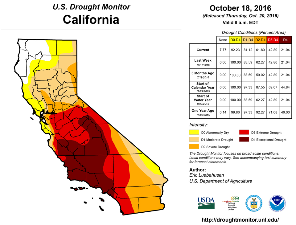
Heavy drought-easing precipitation in northern portions of the region contrasted with dry, warmer-than-normal conditions across the south. In California, some modest drought reduction was noted in the north, with the biggest change for the week noted in the Impact Type; much of the drought in central and northern California is now a Long-term Drought (denoted on the map by an “L”), meaning that short-term impacts have been eased or alleviated but long-term impacts (ground water, reservoir supplies, etc.) remained.From the Pacific Northwest into the northern Rockies, a steady fetch of Pacific moisture coupled with a series of disturbances triggered heavy rain and mountain snow. Event totals varied considerably based on topography, but liquid-equivalent amounts averaged 3 to 15 inches in the Coastal Ranges to 1 to 4 inches in the northern Rockies. Areas lee of the mountains received less, but amounts of 0.5 inch to locally more than an inch were observed. As a result, widespread 1- and 2-category reductions were made in areas where the heaviest precipitation fell.
Meanwhile, moderate to heavy rain and mountain snow (2-10 inches liquid equivalent, locally more) were observed in northern California, the Sierra Nevada, and along the immediate coast as far south as Santa Cruz. While the rain was beneficial for streamflow and soil moisture recharge, the state will need more cool-season precipitation to undo the far-reaching impacts of the ongoing 5-year drought.
In the Great Basin and Four Corners, a modest reduction of D0 in eastern Nevada was supported by feedback from local experts following near- to above-normal precipitation in these areas during the just-concluded 2015-16 Water Year. The rest of the region remained unchanged, though a continuation of hot, dry conditions may necessitate increases in drought intensity and coverage over the upcoming weeks.
Alaska, Hawaii, and Puerto Rico
In Alaska, Abnormal Dryness (D0) was added to coincide with the driest areas over the past 60 days (40-60 percent of normal) and rapidly declining streamflows. In Hawaii, Moderate Drought (D1) was expanded across southern Kauai due to the impacts of below-average rainfall on vegetation and non-irrigated pastures. There were no changes to the drought depiction in Puerto Rico.Looking Ahead
Unfavorably dry conditions are expected to linger over many of the nation’s drought areas over the next 5 to 7 days. In particular, little — if any — rain is expected over the Southeast as well as the southern half of the Great Plains. Exceptions to the dry outlook include the potential for locally heavy rain from the central Appalachians into northern New England, and from northern California into the northern Rockies and Pacific Northwest. The NWS 6- to 10-day outlook for October 25- 29 calls for near- to above-normal temperatures over most of the nation, with cooler-than-normal conditions confined to New England and the central Pacific Coast. However, the outlook features a wetter-than-normal signal from the Pacific Coast into the Ohio Valley and Great Lakes, with drier-than-normal conditions limited to portions of Texas and from the Delta into the Southeast and Mid-Atlantic States.Author(s):
Eric Luebehusen, U.S. Department of Agriculture
Dryness Categories
D0 ... Abnormally Dry ... used for areas showing dryness but not yet in drought, or for areas recovering from drought.Drought Intensity Categories
D1 ... Moderate DroughtD2 ... Severe Drought
D3 ... Extreme Drought
D4 ... Exceptional Drought
Drought or Dryness Types
S ... Short-Term, typically <6 months (e.g. agricultural, grasslands)L ... Long-Term, typically >6 months (e.g. hydrology, ecology)
Source: National Drought Mitigation Center

