September 19, 2014 - On July 25, 2008 at 3:10 P.M., target shooters in the Sherlock Creek Canyon near its confluence with the Merced River ignited the beginnings of a wildfire which would be named the Telegraph Fire. If the shooters looked up Sherlock Creek, they would see the steep slopes of Telegraph Mountain on their left. On their right, they would see the bottom end of Mt. Bullion. Looking straight up Sherlock Creek, they would see Sherlock Mountain and Whitlock Mountain. All of the terrain is very steep, and was covered at the time with thick, old growth chaparral mixed with scrub oak. The outside temperature was hot, humidity was low, and the wind was blowing from the river up the canyons. There had been no fuel reduction activity in the area since the Mariposa County Rangeland Improvement Association conducted a controlled burn which included Telegraph Mountain in 1954.
At around 5:00 P.M. on that day, a few local residents, having seen the smoke, gathered on Sherlock Road at the Whiskey Flat overlook to watch the fire’s progress. Several members of historic families who were familiar with the fire danger Telegraph Mountain presented to the Midpines Area began thinking about evacuation. Though the fire was still down in the canyon more than four miles away; there was an evacuation order the next day, and residents were off their property for a week
The fire progressed uphill a vertical distance of 2000 feet, assisted by the steep canyons which formed chimneys and intensified the fire. It proceeded along Mt. Bullion scorching the ridgeline and the east side of the mountain to stop within sight of the town of Mariposa. It came up Sherlock Creek Canyon and jumped Sherlock Road near the Whiskey Flat overlook, and burnt along Sherlock Mountain stopping short of Lakeside Drive off Colorado Road. It came up Mosher Road and scorched the north half of Whitlock Mountain. It came around Telegraph Mountain and up Saxon Creek, stopping short of Sherlock Road and Rancheria Creek Road. It jumped the Merced River and went upstream, burning the Halls Gulch and Goods Gulch watershed, burning the area around Black Mountain, threatening the homes across the river from Briceburg, and stopping short of the Clearing House Mine. The transmission power line between Exchequer Power Station and Yosemite Valley was melted in spots by the intensity of the fire.
As of August 1, 2008, the combined efforts of the Unified Command (USFS, BLM, CalFire, Mariposa Fire, and units from all over the west) had deployed 575 engines, 16 helicopters, 12 air tankers, 65 bulldozers, 55 water tenders, and over 4,500 firefighters. There was even a unit from Greece! The cost to the taxpayers exceeded $37,000,000. At the end, on August 6, over 30,000 acres had been burned, 30 residences destroyed, 100 outbuildings burned, and 38 fire fighters injured, none fatally. At a peak time during the fire, over 4,000 residences were threatened. Once again, thanks go to the fire fighters for their hard work and the risks they took to save our homes and our land.
Midpines, the community most affected by the Telegraph fire, consists of wildland with a mixture of large and small parcels and about 900 residences. The residences tend to exist in clusters along county roads or along private side roads. The zoning in most areas of Midpines is Mountain Home, with a 5 acre minimum parcel size. There are large areas in-between the clusters that are unimproved. Most parcels in Midpines not touched by the Telegraph Fire still have heavy fuel loads (brush and other low-growing flammables) which represent wildland fire risk to their owners and to neighbors. There are more than 15,000 acres in this sorry state. The fuel loads in some areas exceeds 100 tons per acre.
There are a lot of places in Mariposa County that have the same problem as Midpines. Think about the areas along Triangle Road, around Jerseydale, Greeley Hill, Bootjack, Ponderosa Basin and the western county to name a few examples. Judging by the low level of activity to reduce fuel on unimproved land undertaken by landowners in recent years, community memory is short. As a community we are more than familiar with the potential destruction from wildfire. Unfortunately it seems we’re forgetting that our own home could be in the path of the next fire.
Part One: Fire Ready Group in Mariposa County: Fire History in the Sierra Foothills
Part Two: Fire Ready Group in Mariposa County: Fire Safety and Volunteerism in the Mid-20th Century
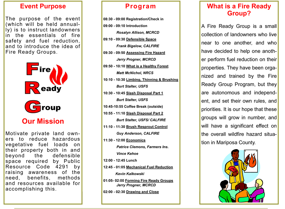
Below is a flyer for the First Annual Fire Ready Workshop to be held in Midpines on October 11, 2014.