


California and National Drought Summary for December 6, 2016
Summary
December 8, 2016 - During the past 7-days, several frontal systems moved across the contiguous United States. Heavy precipitation (generally 2-6 inches, locally 10 inches or more) fell from southern Texas east-northeast across the Gulf Coast states and the Tennessee Valley. Two inches of precipitation (liquid equivalent) or more was also reported across portions of the Northeast and the Pacific Northwest. Within the first 48 hours of the new drought week (which started at 7am EST Tuesday, Nov 29), there were approximately 215 preliminary, filtered reports of severe weather across this region, as indicated by the Storm Prediction Center in Oklahoma. Most of the remainder of the Lower 48 states reported light to moderate precipitation (less than 2 inches).The Northeast, Mid-Atlantic, and eastern Great Lakes region
Despite these regions receiving moderate to heavy precipitation (0.5-inch or greater) during the past 7-days, very few modifications were rendered to the drought depiction. The short-term precipitation is certainly helpful, but it is not enough to offset significant, long-term deficits. As the rainwater percolates deeper into the ground, recharging of the soils will occur. In various locations, the rainwater has not yet made it into deep groundwater wells, nor has it runoff or boosted stream flows substantially. However, this is an important first step, and if these regions receive significant precipitation during the upcoming week, more widespread modifications may be needed to the drought depiction next week. For this U.S. Drought Monitor map, only a few small alterations were made. These included one-category improvements in northern Maine and around the Portland area, and in and around the New York City/northeast New Jersey area, based on recent precipitation amounts and local reservoir conditions. In contrast, abnormal dryness (D0) was expanded across southern New Jersey and throughout Kent County in central Delaware, where lighter rains fell.The Southeast/Lower to Middle Mississippi Valley
As noted in the Summary section above, heavy precipitation fell across much of this region. The Advanced Hydrologic Prediction Service (AHPS) depicts a broad swath of heavy rainfall, oriented in a southwest to northeast direction. The swath extends from southern Texas northeastward into the Tennessee Valley, and eastward across the Gulf Coast states. The heaviest rain amounts were on the order of 10 inches or more, across extreme southwest Louisiana and nearby parts of the Upper Texas Coast, and near where the states of Alabama, Georgia, and northern Florida meet. In general, a one-category improvement was made to the drought depiction in areas which received 3 inches of rain or more during the past 1-2 weeks. This included eastern Arkansas, Louisiana, Mississippi, and significant portions of Alabama, Georgia, the Florida Panhandle, and the higher terrain of the Carolinas.Tennessee and Ohio Valleys
Precipitation amounts ranged from 2-8 inches across most of Tennessee during the past 7-days, and about 2-4 inches in southeast Kentucky. A one-category improvement was made in these areas. During the past 14-days, 3-6 inches of rain was observed in a region centered near Memphis, TN, which included the Missouri bootheel, far western Kentucky, eastern Arkansas, southwest Tennessee and adjacent parts of Mississippi. A one-category improvement was also made for these areas. USGS stream flow gauges generally indicate near-average stream and river flows.Northern and Central Great Plains
Recent snowstorms played a key role in the removal of moderate drought (D1) in south-central North Dakota, where AHPS 14-day departures from normal precipitation (DNPs) span 2-4 inches. In the past month, conditions have generally improved over most of the state. The exception is in extreme southwest North Dakota, where D0 was expanded slightly northward, and D1 was introduced to Bowman County, based on precipitation data and anecdotal testimonies. In nearby South Dakota, northeast portions of the state were improved by a category, based on 30-day DNPs. However, some degradations were made to the depiction in the southwest portion of the state based on precipitation deficits and abnormally warm temperatures, particularly over the last 30-days. Other considerations that went into the changes were the 1-month SPEI (Standardized Precipitation Evapotranspiration Index) for November, seasonal snowfall maps, and current VIC (Variable Infiltration Capacity) soil moisture conditions.Southern Great Plains
In Texas, a reassessment of drought conditions was made to incorporate the latest precipitation data, and many smaller-scale changes were made. AHPS 14-day DNPs reveal precipitation departures on the order of 1-5 inches in south-central and southern Texas, and 2-10 inches in eastern Texas. Small-scale changes were also made to the depiction in north-central Oklahoma (Counties of Garfield, Noble, Kingfisher, Logan, Oklahoma and Lincoln), where farmers and livestock operators reported instances of failed wheat, very dry conditions, and low farm ponds.Rockies and Intermountain Region
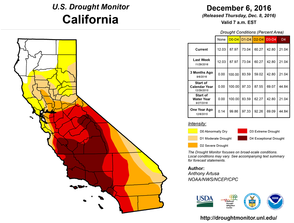
The only changes rendered to this portion of the national drought depiction was made in the High Plains of eastern Colorado. In northern Prowers County (extreme southeast part of state), moderate drought (D1) was expanded due to a dry autumn making its mark on local vegetation, while in the eastern portion of adjacent Kiowa County, a small patch of severe drought (D2) was introduced due to lower precipitation and grasses in poor shape. In the northeast part of the state, D1 was expanded into northern Washington County, northeast Yuma County, Phillips County, and eastern Logan County. This is to account for very spotty winter wheat germination.California
No changes were deemed necessary to the depiction this week.Alaska, Hawaii, and Puerto Rico
No changes were deemed necessary to the depiction this week in Hawaii or Alaska. Residual dryness and drought areas in south-central and southeastern Puerto Rico were removed last week.Looking Ahead
During the next 5 days (December 8-12), moderate precipitation (0.5-1.5 inches) is anticipated from Tennessee through the Great Lakes region, which will at least help preclude additional deterioration for the Tennessee and Ohio Valleys. For most other areas east of the Rockies, precipitation amounts are expected to be less than a half-inch. Locally heavy amounts of precipitation (liquid equivalent of 2-4 inches) are predicted for the higher elevations of the Rockies. Most of the expected precipitation for the Pacific Coast states is forecast to fall in areas that are not currently in drought, with the exception of the Sierras where up to 7 inches (liquid equivalent) is anticipated.For the ensuing 5-day period (December 13-17), odds favor above-median precipitation across approximately the northern and eastern halves of the contiguous U.S., while odds favor below-median precipitation from Arizona eastward to the southern Great Plains, and Alaska.
Author(s):
Anthony Artusa, NOAA/NWS/NCEP/CPC
Dryness Categories
D0 ... Abnormally Dry ... used for areas showing dryness but not yet in drought, or for areas recovering from drought.Drought Intensity Categories
D1 ... Moderate DroughtD2 ... Severe Drought
D3 ... Extreme Drought
D4 ... Exceptional Drought
Drought or Dryness Types
S ... Short-Term, typically <6 months (e.g. agricultural, grasslands)L ... Long-Term, typically >6 months (e.g. hydrology, ecology)
Source: National Drought Mitigation Center

