
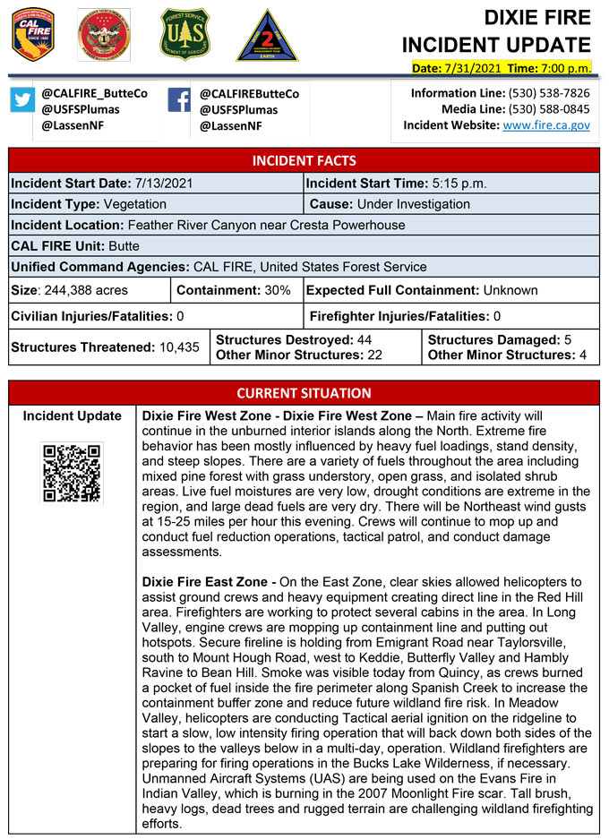
Evening Update Per CAL FIRE: Dixie Fire in Butte County and Plumas County is 244,388 acres and 30% contained for Saturday evening.
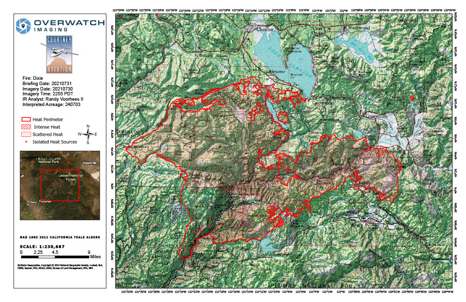
Dixie Fire Infrared Map for Saturday, July 31, 2021
Note: 960 Pixels Wide
Flight Notes: Scattered heat remains through out most of the fire. Fairly minimal outward growth. Unburned areas continue to fill in. Used pervious Nirops perimeter rather than AGOL perimeter due to polygon shapes in agol perimeter. This perimeter seems more accurate but that may account for the smaller than expected change in acreage. Also I noticed a couple locations where I double symbolized the intense and scattered heat. These areas are Intense heat only.
Update: Lassen and Plumas National Forests, July 31, 2021 — Today, the weather forecast will return to hot temperatures and potentially gusty winds, which will dry fuel moistures. Thunderstorms are expected to stay east of the fire, but the potential remains for a chance of showers and gusty winds. Smoky conditions, particularly in drainage basins, will vary in elevation and density.
The Dixie Fire is approximately 240,795 acres with 24% containment. There are over 5,800 fire personnel assigned to the incident. The incident remains in Unified Command, with two teams overseeing the fire: CAL FIRE Incident Management Team 1 on the West Zone and California Interagency Incident Command Team 2 on the East Zone.
On the East Zone, crews will continue to strengthen the fireline protecting homes and structures along the Rush Creek Road, where the fire burned into the 2012 Chips Fire burn scar in the Red Hill area between State Route 70 and Muggins Creek. From Dark Ravine to Round Valley Reservoir, crews guided fire to more level terrain, where it could more easily be contained. Containment line is holding along Emigrant Road above Taylorsville, from Mt. Hough south to Quincy, as well as from Keddie west to Butterfly Valley, Hambly Ravine and Bean Hill. Today, as firefighters mop up and patrol for hotspots, they will be on the lookout for burned trees or “snags” that are extremely dangerous, as they fall without warning. Crews have spent several days laying hoses, setting sprinklers and cutting line to do a planned slow, low-intensity strategic firing operation on roughly 1,500 acres in the Bucks Lake Wilderness Area from Bean Hill south to Meadow Valley, when weather conditions allow. The Evans Fire burned actively last night in heavy dead and downed fuels. The fire is reported at 75 acres.
On the West Zone, fire behavior is expected to increase due to drying conditions today. Fire continues to move towards control lines burning unburned interior islands and ridges. No growth is expected on the West Zone, but interior islands will continue to burn as planned. Unstable conditions will continue each afternoon with the potential for large column growth over areas of intense heat. Crews continue to provide structure defense in communities at risk, construct direct and indirect line to secure the fire perimeter, and contingency lines in both zones.
The public is encouraged to stay tuned to the latest fire information. Be prepared by having a full tank of gas, collecting important documents and medications. For additional tips, visit https://www.readyforwildfire.org/.
Current Forest Closure information can be found at: https://inciweb.nwcg.gov/incident/closures/7690/
Current Evacuation information can be found at: https://tinyurl.com/4nm69873
Current Road Closures: https://roads.dot.ca.gov/roadscell.php
Update: Smoke/Air Quality Outlook for the Dixie Fire in the Eastern Sierra for Saturday, July 31
Update: Butte County Sheriff The Butte County Sheriff’s Office is LIFTING the EVACUATION WARNING for the Pulga and East Concow areas.
Inskip remains under an EVACUATION WARNING.
Update: Dixie Fire East Zone Operations Morning Briefing Video for Saturday, July 31, 202
July 31, 2021 - Dixie Fire in Butte County and Plumas County is 240,795 acres and 24% contained for Saturday morning.
Update 9:20 A.M. CAL FIRE
'Click' here to view full PDF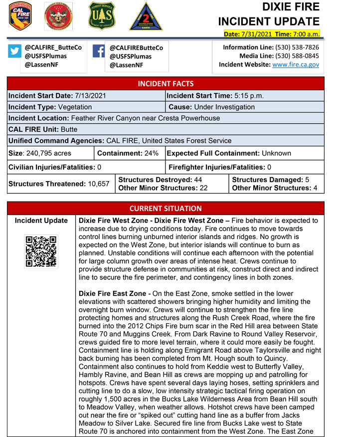
Basic Information
| Current as of | 7/31/2021, 6:30:46 AM |
| Incident Type | Wildfire |
| Cause | Under Investigation |
| Date of Origin | Tuesday July 13th, 2021 approx. 05:15 PM |
| Location | Feather River Canyon near Cresta Powerhouse |
| Incident Commander | CALFIRE Incident Management Team 1/California Interagency Incident Management Team 2 |
| Incident Description | Wildfire |
| Coordinates | 39.819 latitude, -121.419 longitude |
Current Situation
| Total Personnel | 5,864 |
| Size | 240,795 Acres |
| Percent of Perimeter Contained | 24% |
| Estimated Containment Date | Friday August 13th, 2021 approx. 12:00 AM |
| Fuels Involved |
Timber (Litter and Understory) Timber (Grass and Understory) Brush (2 feet) Fuel moistures are historically low, ERCs and BI are in the 97-99% |
| Significant Events |
Moderate Torching Backing Creeping Fire activity moderated over the evening hours with interior islands continuing to burnout. |
Outlook
| Planned Actions |
Construct direct and indirect line to secure fire perimeter. Construct contingency lines in both zones. Provide structure defense in communities at risk: Paxton, Greenville, Jonesville, Crescent Mills, Taylorsville, Canyondam, Butte Meadows, Bucks Lake, Meadows Valley, Rush Creek and Greater Alamnor area. East Zone: Multiple firing operations will continue. Continue tactical patrol in the communities impacted by fire. |
| Projected Incident Activity |
Fire behavior expected to increase due to drying conditions. Fire continues to move towards controls lines burning unburned interior islands and ridges. Most expected growth will be to the west towards Butte Meadows. On the East Zone expected area to grow is Division X within the Bucks Wilderness area. |
| Remarks |
California Interagency Incident management team 2 (CIIMT 2) has command of the East Zone. State DPA: 6551 Federal DPA: 213461 |
Current Weather
| Weather Concerns |
EAST ZONE: Observed: Patchy dense smoke continued late this morning and early this afternoon across the Dixie Fire. Mid to upper level clouds were present with building cumulus. Afternoon temperatures have risen into the 80s with humidity values sinking down into the twenties and thirties. Forecast: The shower and thunderstorm threat will continue this afternoon and the coverage is expected to be greater than that of Thursdays activity and between 40 and 50 percent. Thunderstorms will be capable of strong and erratic outflow winds as well as occasional to frequent cloud to ground lightning. Brief heavy rain will be possible as well. The best concentration of precipitation is expected to be in the vicinity of the Evans Fire early this afternoon with other regions experiencing showers and storms approaching from the southeast. Outside of thunderstorm activity, breezy and very warm weather is expected this afternoon with humidity values falling down into the mid-teens to near 20 percent. Patches of dense smoke and haze will likely persist in some of the drainage basins and valleys. Highs will remain largely in the mid to upper 90s. For tonight dense smoke and haze will drain back into the basins resulting in poor visibilities, except where lingering showers and storms occur. A gusty outflow threat may continue into the evening hours but most activity should subside by midnight. Overnight low temperatures are not expected to be quite as low in the valleys and drainages, but it will likely remain chilly with temperatures in the upper 50s to near 60 degrees in spots. Overnight humidity values will range as great as 50 percent...even at higher elevations in spots to above 70 percent in the drainage bottoms. WEST ZONE: Strong upper level ridging will continue to bring very warm and unstable conditions to the area. There is a slight chance thunderstorms on Sat though it is more likely they will remain north and east of the fire area. Unstable conditions will continue each afternoon with the potential for large column growth over areas of intense heat. Increasing S-SW flow and an approaching upper level trough will bring a significantly drier air mass into the area for the first half of next week. RHs will fall rapidly for Mon-Wed with SW winds increasing. Observed Weather Conditions 7/30 Fri afternoon Wind: SW to NW winds 4-8 mph with gusts up to 15 mph Max Temp: Upper 80s 2000-3000 ft valleys and upper 70s to low 80s 6000-7000 ft ridges Min RH: 26 to 44% as of 1500 Expected Weather Conditions 7/30-31 Fri Night Wind: NE locally 15 mph with gusts to 25 mph Feather River Canyon and adjacent valleys Min Temp: Lower 70s ridges and 60s valleys Max RH: 30-35% ridges and 55-60% valleys Forecasted Weather for Next Operational Period 7/31 Sat Day Shift Wind: SW 10-15 mph gusts to 25 mph Max Temp: Upper 90s to low 100s 2000-3000 ft valleys to mid 80s 6000-7000 ft ridges Min RH: Mid teens Forecasted Weather for Next Operational Period 7/31-8/1 Sat Night Shift Wind: NE locally 15 mph with gusts to 25 mph Feather River Canyon and adjacent valleys Min Temp: Lower 70s ridges and 60s valleys Max RH: 30-35% ridges and 55-60% valleys |
Click here for: Dixie Fire in Butte and Plumas Counties Friday, July 30, 2021 Updates