


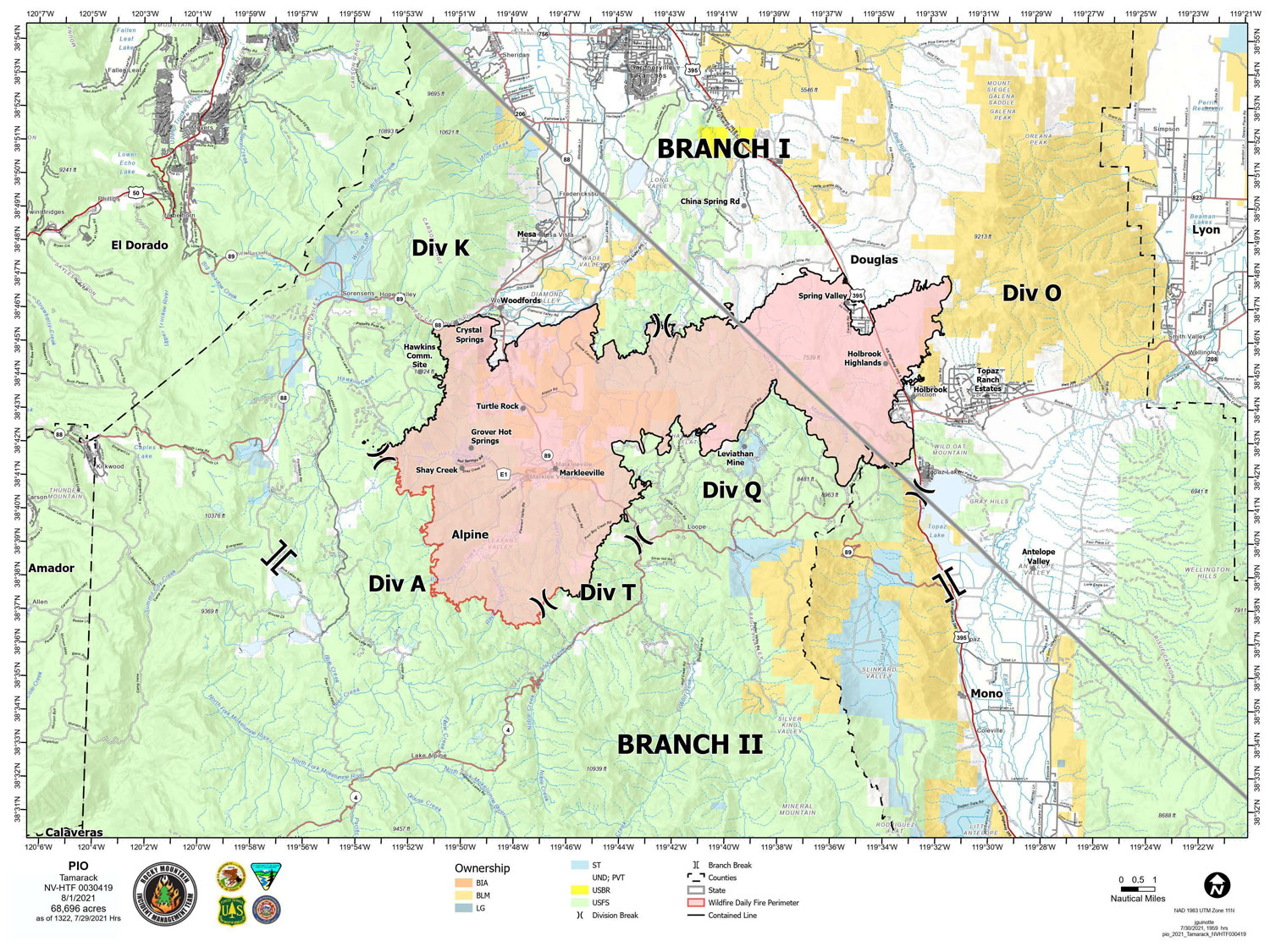
Map for Sunday, August 1, 2021
Note: 1,200 Pixels Wide
NOTE: Maps represent approximate information.
Evening Update: The Tamarack Fire as of Sunday evening is now at 68,696 Acres with 82% Containment.
Basic Information
| Current as of | 8/1/2021, 6:06:00 PM |
| Incident Type | Wildfire |
| Cause | Lightning |
| Date of Origin | Sunday July 04th, 2021 approx. 04:00 PM |
| Location | 16 Miles south of Gardnerville, NV |
| Incident Commander | Dan Dallas, IC Bill Hahnenberg, Deputy IC |
| Incident Description | This Incident Continues To Be Managed With A Full Suppression Strategy, However Steep Inaccessible Terrain In Division Alpha Necessitates A Suppression Strategy Of Confinement |
| Coordinates | 38.628 latitude, -119.857 longitude |
Current Situation
| Total Personnel | 419 |
| Size | 68,696 Acres |
| Percent of Perimeter Contained | 82% |
| Estimated Containment Date | Tuesday August 31st, 2021 approx. 12:00 AM |
| Fuels Involved |
Timber (Grass and Understory) Chaparral (6 feet) Timber (Litter and Understory) |
| Significant Events |
Active Backing Creeping Smoldering Fire is burning in mixed conifer, Pinyon Juniper and brush fuel types, with creeping and smoldering. Single tree torching possible. |
Outlook
| Planned Actions |
Branch I - Keep fire south of China Spring and west of Highway 395. Keep fire south of Highway 88 and east of Blue Lake Road. Continue right sizing organization. Branch II - Keep fire north of Highway 89 (Monitor pass) and Hwy 4. Continue right sizing organization. Structure - Secure structures in all Branches. Continue right sizing organization. Night Operations - Patrol and secure structures in all branches. |
| Projected Incident Activity |
12 hours: Primarily creeping and smoldering fire. Additional precipitation is anticipated on the fire today. 24 hours: Creeping fire with smoldering and limited potential spread. |
| Remarks |
Acreage estimated from FireWatch flight on 7/29/2021 at 1322. Steep rugged terrain in Division Alpha necessitates a suppression strategy of confinement. Perimeter in Division Alpha represents 18% of the total fire perimeter. The remaining perimeter (82%) has been fully contained. |
Current Weather
| Weather Concerns |
Today's weather was mostly cloudy with numerous thunderstorms in the area. Some rain fell on the fire area along with gusty outflow winds. High Temps 68-80. Min RH 25-35%. Upslope 4-8 mph with WSW 7-12 G20 in the afternoon and evening. HAINES 3, LAL 3 CW 25%. Tonight-Partly cloudy, few lingering showers possible. Min Temp 45-55. Max humidity around 65-95%. West winds 10-15 mph G25, winds calming down after midnight. Monday-Sunny. High Temps 82-95. Min RH 15-20%. Light upslope in the morning, Southwest 10-15 mph G30. |
Update: Tamarack Fire Operations Briefing Video for Sunday, August 1, 2021
Update: Smoke/Air Quality Outlook for the Tamarack Fire in Alpine County for Sunday, August 1
August 1, 2021 - The Tamarack Fire as of Sunday morning is now at 68,696 Acres with 82% Containment.
Sunday, August 1, 2021 – 9:00 a.m.
Rocky Mountain Type 1 Incident Management Team
Dan Dallas, Incident Commander
Information Phone: 775-434-8629 (public and media)
Email: 2021.tamarack@firenet.gov
Information Staffing Hours: 8 a.m. to 8 p.m.
Current Situation: Firefighters added new containment in Division T yesterday. The fire is now 82% contained. Crews continue to patrol and respond to calls of smoke. For extra assurance that containment line will hold, firefighters suppress smoking areas when they’re near the fire perimeter. Some fuels will continue to burn and smoke inside the fire perimeter and do not pose a threat to the containment line. Smokes inside the lines may continue until a “season-ending” weather event brings substantial rain or snow to the fire area.
Aircraft equipped with infrared (IR) sensing technology supports firefighters on the ground. IR is a heat detection system used for mapping and hotspot identification. Maps and heat detection guide incident personnel on where to concentrate resources while crews work to hold and improve the containment lines.
The suppression repair group used excavators to fix dozer line near Spring Valley and Woodfords yesterday, and finished chipping along SR 89. A hand crew repaired hand line near Markleeville. An excavator will continue working today near Spring Valley and chipping operations will continue on the north part of Leviathan Road.
Branch I: Divisions K and O – The north and east edges of the fire are contained and in patrol status. Crews addressed hot spots on the east side of Division K.
Branch II: Division Q and T – With containment complete in Division Q, crews will patrol today. In the southwest part of Division T, firefighters fully contained the line between Indian Creek Road and the east fork of Indian Creek.
Division A – Two wildland fire modules remain in this steep, rocky terrain. Yesterday, they put out one hot spot near the fire perimeter. Due to extremely rugged terrain and minimal fire activity, use of natural barriers and limited fuels will serve to prevent fire spread and potential. This will maximize firefighter safety.
Weather and Fuel Conditions: Storms brought rain and hail to the southern portion of the fire area. Fine fuels, like grasses, are recovering moisture overnight. Heavy fuels, like logs, will continue to burn, despite the rain. The outlook for today is more storms and rain. Monday and the rest of the week are forecast to return to dry and windy conditions.
Closures, and Fire Restrictions: For closures and fire restrictions on National Forest lands visit https://www.fs.usda.gov/alerts/htnf/alerts-notices. Grover Hot Springs State Park and Indian Creek Reservoir Campground remain closed to the public.
Click here for: Tamarack Fire in Alpine County Updates for Saturday, July 31, 2021
