


Click here for: California Dixie Fire Tuesday, August 24, 2021 Updates
*Note: Because of internet issues at the meeting, the video below has a few glitchy spots.
Update: Dixie Fire East Zone Virtual Community Meeting Evening Update Video for Monday, August 23, 2021
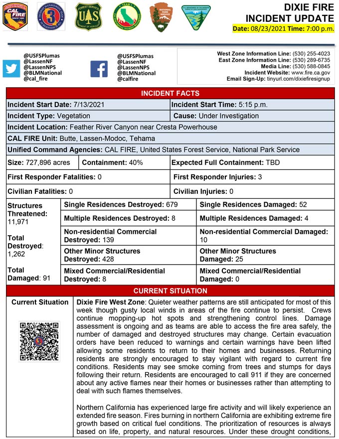
Evening Update Per CAL FIRE: California Dixie Fire is at 727,896 Acres, with 40% Containment, and 6,001 personnel assigned for Monday evening.
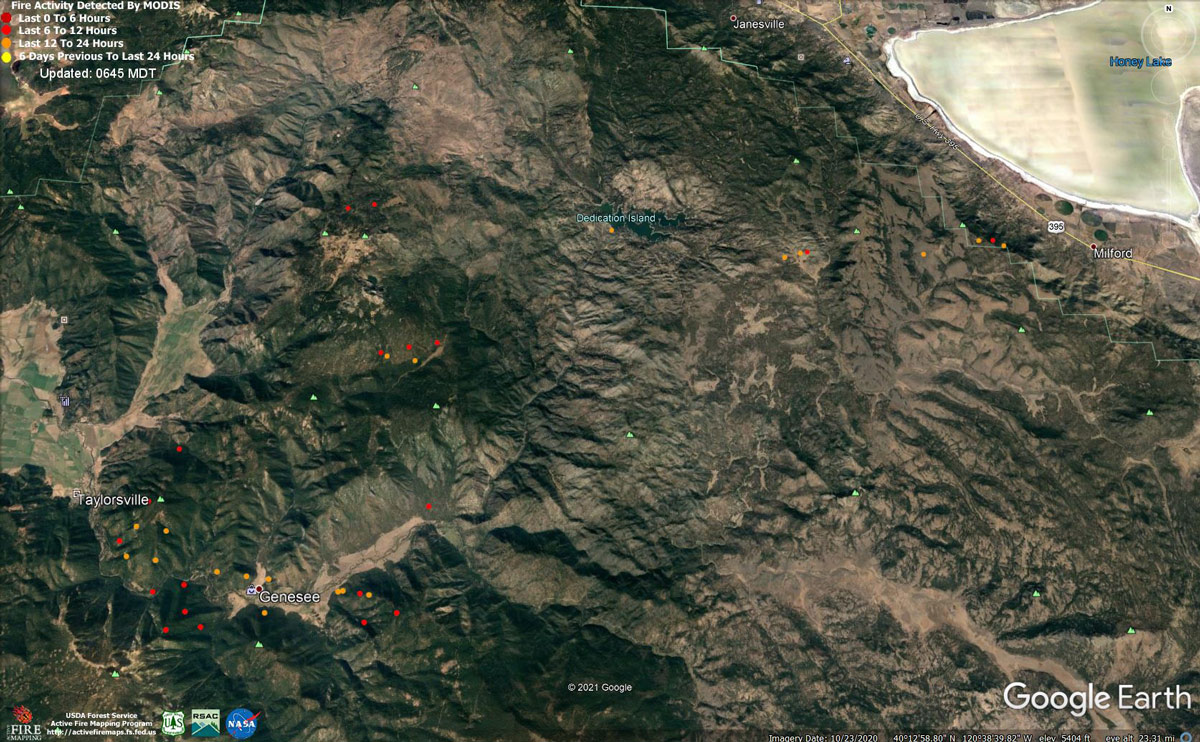
MODIS map of the Dixie Fire on Monday at 5:45 A.M PST
Note: 1,200 Pixels Wide - Note: Older Yellow not shown
MODIS Active Fire Mapping Program Frequently Asked Questions
Update: Dixie Fire Evacuation Information & Updates for Monday, August 23, 2021
Update (NEW): Evacuation Order and Warnings Reduced for Some Areas of the Dixie Fire
Update: Dixie Fire East Zone Operations Morning Briefing Video for Monday, August 23, 2021
Update: Dixie Fire West Zone Operations Morning Briefing Video for Monday, August 23, 2021
Update: Smoke/Air Quality Outlook for the Dixie Fire in the Eastern Sierra for Monday, August 23, 2021
Update: Dixie Fire Morning Briefing Video for Monday, August 23, 2021
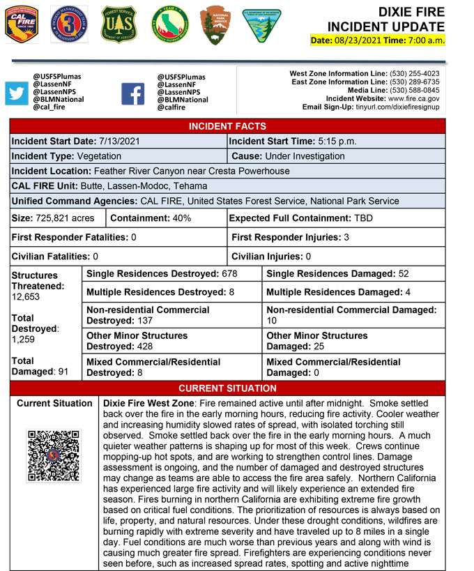
August 23, 2021 - Dixie Fire is 725,821 acres and 40% contained for Monday morning.Update 7:20 A.M. CAL FIRE
Basic Information
| Current as of | 8/23/2021, 6:18:01 AM |
| Incident Type | Wildfire |
| Cause | Under Investigation |
| Date of Origin | Tuesday July 13th, 2021 approx. 05:15 PM |
| Location | Feather River Canyon near Cresta Powerhouse and Lake Almanor. |
| Incident Commander | Billy See, CALFIRE IMT 3 Jerry McGowan, CIIMT 1 Jay Lusher, NPS/BLM |
| Incident Description | Wildfire |
| Coordinates | 39.819 latitude, -121.419 longitude |
Current Situation
| Total Personnel | 6,001 |
| Size | 725,822 Acres |
| Percent of Perimeter Contained | 40% |
| Estimated Containment Date | Thursday September 30th, 2021 approx. 12:00 AM |
| Fuels Involved |
Fuel moistures are historically low, ERCs and BI are in the 97-99%. Northern California remains under a Fuels and Fire Behavior Advisory. |
| Significant Events |
Active: Uphill Runs Group Torching Short-range Spotting Narrative: Fire remained active until after midnight. Smoke settled back over the fire in the early morning hours, reducing fire activity. Southwest winds will continue to gust up to 20 mph at ridgetops through the day on Monday. Drier air continuing to move into the area will drop RHs back into the teens, which is a trend that will continue all week long. |
Outlook
| Planned Actions |
Construct direct and indirect line to secure fire perimeter. Direct line construction in the Westwood area will require a heavy resource presence. Provide for service calls within communities impacted by the fire: Chester, Hwy 36 corridor, Hwy 89 Corridor, Hwy 395 corridor, Paxton, Greenville, Jonesville, Crescent Mills, Taylorsville, Prattville, Canyondam, Butte Meadows, Bucks Lake, Meadows Valley, Rush Creek, Warner Valley, Pecks Valley, Williams Valley, Hunt Canyon, Susanville, Janesville, and the Greater Almanor area. Structure protection and heavy mop up continues in Warner Valley, Cradle Valley, and Wilcox Valley. Protect threatened areas of Janesville, Indicator Peak and Loan Peak. Heavy mop and patrol of communities impacted by the fire front. "Make Safe" for repopulation. Resources will be working from Dyer Mountain east to Mountain Meadow Reservoir utilizing direct line to complete action in that area. Continued mop up of and patrol of 1,000-hr fuels will require a significant amount of resources due to the volume of fuels and the steep and rugged terrain. Priority areas include structure protection in Janesville/Milford area, the Hwy 36 corridor, and the Mill Creek drainage. Fire is well established in the Mill Creek Plateau. Continue direct and indirect line construction to prevent the fire from crossing the Mill Creek drainage and impacting the communities of Mill Creek and Mineral. If the fire were to become established in the Mill Creek drainage, large fire growth is expected. Resources have been surged to the Genesee Valley area to protect the community of Taylorsville and limit spread from spot fires and active flanks.Resources were also surged to the Hwy 36 corridor to strengthen holding actions and monitor for spots across the highway. Continued holding actions and point protection of communities and critical infrastructure will require a significant resource presence for the next several operational periods. Tactics that utilize fewer resources are being implemented in the Lassen Sector. Firing plans are being developed for West Zone - Div K. |
| Projected Incident Activity |
12 hours: Moderate-to-high overnight conditions, with thermal belt supporting active nighttime fire behavior. Fire is down to and across Genesee Valley road today, threatening many structures along Genesee Valley road. Smoke over area has moderated fire spread last few days, today it exposed to clear skies with much more active fire activity today. Spot fire along the escarpment west of Hwy 395 on eastside of fire could impacting communities of Milford as fire spreads laterally to the north and south along the escarpment. Potentially impacting Janesville on north-side of the fire along Hwy 395. Overnight recovery will be up to 40-60%. Potential for crews to make progress on building containment lines and firing operations with increased Rh, cooler nighttime temperatures, and decreased nighttime windspeeds. 24 hours: Temperatures will be in the 80's today. Forecasted winds continue out of the SW today. The atmosphere will be improving in stability with a Haines of 5. Fire behavior will consist of wind, slope, and fuel continuity alignment supporting surface fire spread, roll out, isolated torching and spotting. Moderate overnight recoveries may provide opportunity for line construction and firing operations. Expect comparable fire behavior as the previous operational period. Fire will almost complete in backing down to and impacting Genesee Valley today, threatening many structures along Genesee Valley road. 48 hours: Moderate fire risk burn environment. Temperatures will be in the upper 80's to low 90's today and will be similar over the next few operational periods. Fire behavior would include wind driven surface fire, group torching, crown runs with alignment and spotting. Moderate overnight recoveries may provide opportunity for line construction and firing operations. Local thresholds will be exceeded. Expect an increase in fire activity with clear air. 72 hours: Temperatures will be in the mid 80's over the next few shifts. Expect comparable fire behavior as the previous operational period. Forecasted hot and dry weather through the end of the week. Anticipated after 72 hours: Expect similar burning conditions. Temperatures will remain in the high 80's throughout the week. |
| Remarks |
Continuation of Box 4: California Interagency Incident Management Team 1(CIIMT 1)is in command of the East Zone. East Zone Unified Command Agencies: Plumas National Forest and Lassen National Forest CAL FIRE IMT3 is in command of the West Zone. West Zone Unified Command Agencies: Bureau of Land Management, CAL FIRE, Lassen National Forest, National Park Service Continuation of Box 25: The fire area is in portions of Butte, Lassen, Plumas, Shasta, and Tehama counties. Active fronts are in the Greater Lake Almanor area, Lassen NF, and Lassen NP, as well as on several private timber ownerships. Box 31(H): Major reduction in evacuation number due to a combination of repopulation efforts in Lassen County and more accurate data provided through Zonehaven on current warnings and orders in the five affected counties. Continuation of Box 31(J): Civilians in indoor temporary shelters - 51 Civilians in outdoor temporary shelters - 248 Continuation of Box 32(E): East Zone - 3 responder injuries West Zone - 3 responder injuries Continuation of Box 33: State of Emergency for Butte, Lassen, and Plumas counties was declared by Governor Newsom on July 23rd, 2021. Butte, Lassen, Plumas, and Tehama Counties have declared local emergencies. FMAG has been approved for Butte, Plumas, and Lassen Counties. The Plumas National Forest implemented Forest Order No. 05-11-00-21-18, effective from July 25, 2021, through September 30, 2021. The Lassen National Forest implemented Forest Order No. 06-21-07, effective from July 27, 2021, through September 30, 2021. Continuation of Box 38: Additional values at risk threatened: National Scenic and Historic Trails: Pacific Crest Trail, Bizz Johnson National Recreation Trail Inventory Roadless Area (IRAs): Bucks Lake (PNF), Butt Mountain (PNF), Chips Creek (LNF), and Cub Creek (LNF). Experimental Forests: Swain Mountain, Blacks Mountain. Research Natural Areas (RNAs): Green Island Lake (LNF), Soda Ridge (LNF), Cub Creek (LNF), Mount Pleasant (PNF). Air Quality impacts: Reno, Carson City, Susanville, Sparks, Fernley and Quincy. Airports impacted by TFR and smoke impacts: Rogers Field (Chester Airport), Ganser Field (Quincy Airport), Westwood Airport, Susanville Municipal Airport, Herlong Airport Wilderness: Bucks Lake Wilderness (PNF), Caribou Wilderness (LNF), Lassen Volcanic National Park Wilderness. Commercial timber ownerships: Sierra Pacific Industries, W.M. Beaty and Associates, Collins Pine. An estimated $1 Billion dollars of timber has already been destroyed with an additional $1 Billion still threatened. Total cumulative private timber loss -260,724 acres. Substantial losses of private and public timberlands have released decades of sequestered carbon, releasing it into the atmosphere with uncalculatable impacts to greenhouse gas accumulations. Waterways: Philbrook Lake (PG&E, LNF), North Fork of the Feather River (PG&E, PNF), Silver Lake (Drinking water, PNF), Thompson Lake (Drinking water, PNF), Butte Creek (T&E species: chinook and steelhead, PNF), Deer Creek (T&E species: chinook and steelhead), Oliver Lake (T&E species: Sierra-Nevada Yellow-legged Frog, LNF), Gold Lake (T&E species: Sierra-Nevada Yellow-legged frog, (PNF), Rock Lake T&E species: Sierra-Nevada Yellow-legged frogs, (PNF) Additional T&E species (not listed above): California Spotted Owl, Valley Elderberry Beetle, Shasta Crayfish, Cascades frog, California Red-Legged Frog, Bald Eagle, Golden Eagle, Grey wolf, Fisher, California wolverine, and Sierra Nevada red fox. |
Current Weather
| Weather Concerns |
EAST ZONE: Ridgetop winds continued to gust from the southwest up to 20 mph. Increasing instability led to a Haines Index of 4 and will be followed in subsequent days by a Haines of 5. Relative humidity fell into the teens starting a downward trend that will last all week resulting in near single digit readings by the end of the week. Tonight: Thermal belts will start to develop after sunset leading to poor RH recoveries along the mid slopes. Some locations won't see RHs above 30% tonight. Winds will calm down and become terrain driven after sunset leading to smoky conditions overnight in the valleys. WEST ZONE: Heavy smoke from the Dixie incident and surrounding wildfires settled in over the region. Terrain driven winds prevailed across the incident early in the day before turning southwest in the early afternoon. Wind speeds averaged around 8 to 12 mph with a few higher gusts around 20 mph over the ridgetops and along the exposed slopes. High temperatures were in the upper 70's to mid-80's with the RH bottoming out in the 15 to 20% range. With the winds being on the lighter side, smoke thinned out briefly during the afternoon hours. The winds are expected to diminish slightly after sunset and become primarily terrain driven in the valleys and canyons. Winds are anticipated to stay 5 to 10 mph along the ridgetops through the night. Recovery may improve in the thermal belt areas. A much quieter weather pattern is shaping up for most of this week. A very weak area of low pressure will remain off the west coast through mid-week keeping light southwest flow over the incident with near normal temperatures and humidity values. High pressure will be building over the area late next week with a warming and drying trend expected. |
Click here for: California Dixie Fire Sunday, August 22, 2021 Updates
