


Note: Click here for Sunday's Caldor Fire Updates
Taking a moment to remember the events of 9/11/01 and honoring the brave men and women who currently serve our country in our time of distress. Source: CAL FIRE Amador-El Dorado Unit
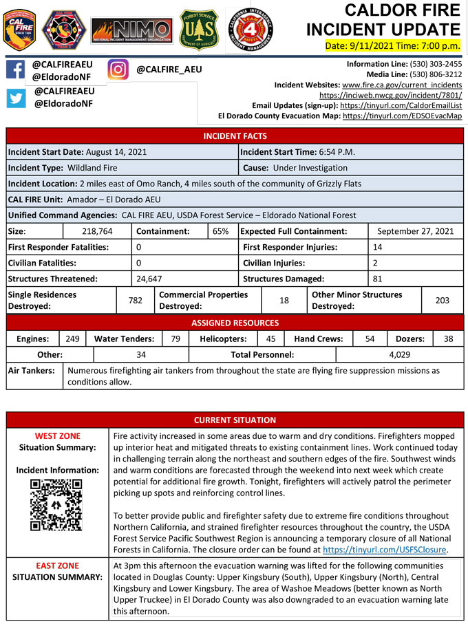
Evening Update Per CAL FIRE: California Caldor Fire is at 218,764 Acres, with 65% Containment, and 4,029 personnel assigned for Saturday evening.
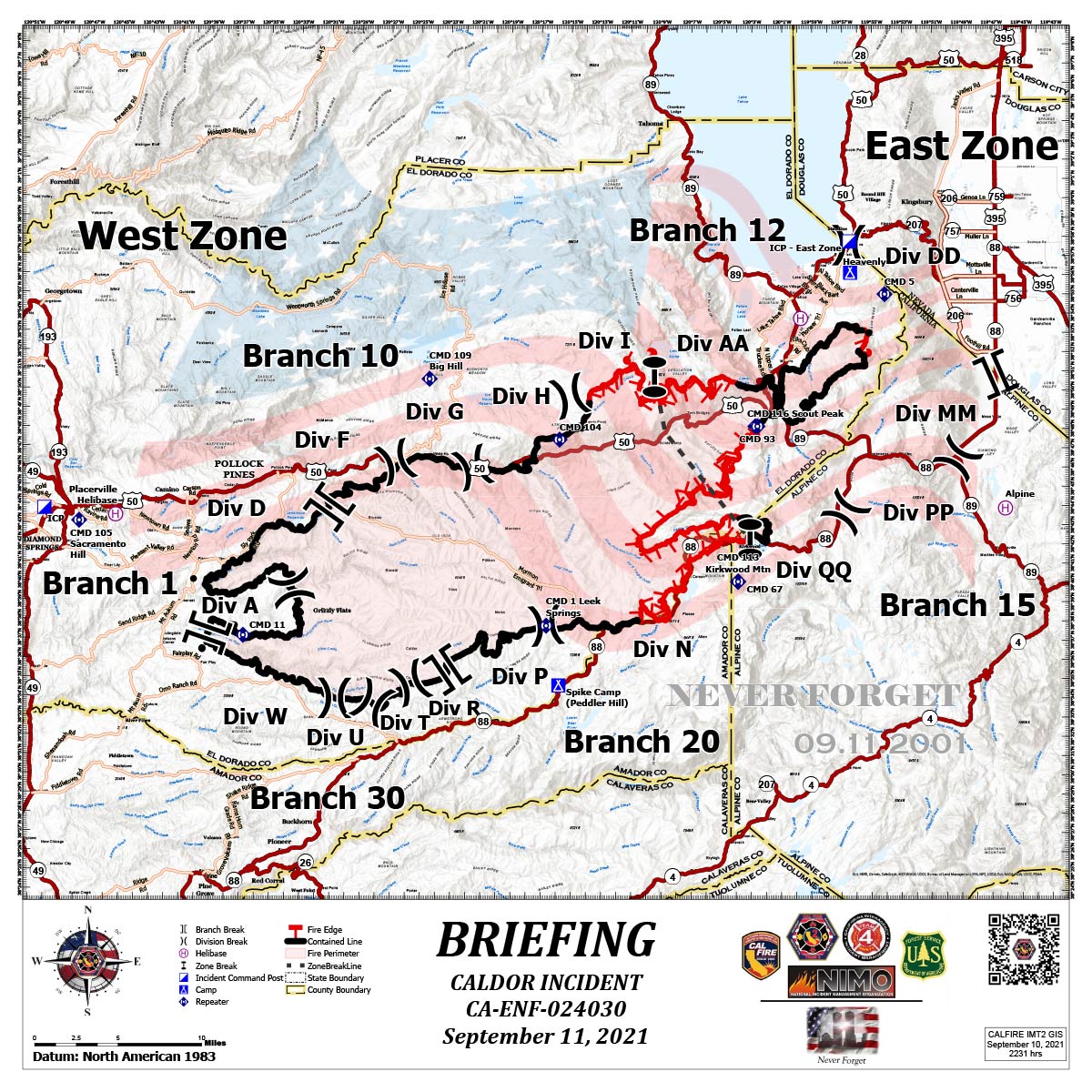
Briefing Map Shows Divisions, Uncontrolled Fire Edge, Completed Dozer Lines.
Note: Map is 1,200 pixels wide.
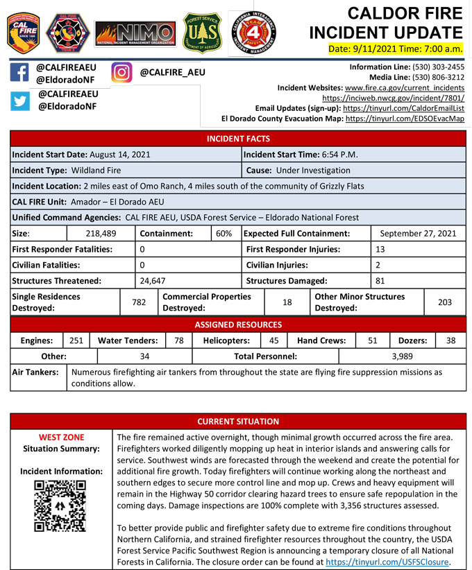
September 11, 2021 - Caldor Fire Update for Saturday Morning, 218,489 Acres with 60% Containment.
Update CAL FIRE
Basic Information
| Current as of | 9/11/2021, 6:52:14 AM |
| Incident Type | Wildfire |
| Cause | Under Investigation |
| Date of Origin | Saturday August 14th, 2021 approx. 07:00 PM |
| Location | Two miles East of Omo Ranch, four miles South of Grizzly Flat |
| Incident Commander | Charlie Blankenheim, CAL FIRE IMT2; Joe Reinarz, USFS NIMO 2; Rocky Opliger, ICT1, USFS CIIMT4 |
| Incident Description | Vegetation |
| Coordinates | 38.586 latitude, -120.538 longitude |
Current Situation
| Total Personnel | 3,989 |
| Size | 218,489 Acres |
| Percent of Perimeter Contained | 60% |
| Estimated Containment Date | Monday September 27th, 2021 approx. 06:00 PM |
| Fuels Involved |
Timber (litter and understory) Light logging slash Brush (2 feet) |
| Significant Events |
The fire remained active overnight, though with minimal growth in Div I and Div N and no additional growth in any of the other divisions. Moderate overnight humidity recovery. Interior islands and green stringers have retained heat that will pose potential threats during the heat of the day. Red Flag Warning forecasted yesterday has been terminated. Fuel moistures remain critically low for both live and dead fuels. SW winds are forecasted through the weekend into next week. SW winds are associated with large fire growth. The Energy Release Component is above the 97th percentile. The Burning Index is well below the 97th percentile due to the rain accumulation in the previous operational period. There is a potential for wind driven surface fire due to alignment. |
Outlook
| Planned Actions |
WEST ZONE: Provide for the life safety of citizens and emergency responders. Implement structure and critical infrastructure defense. Construct control lines and take advantage of targets of opportunity as allowed by fire behavior and resource limitations. Improve and hold established control lines. Identify and establish contingency lines. Tactical patrol of perimeter contained. Aggressive mop-up, backhaul of hose, and tactical patrol will continue in DIV A and D. In DIV N and P, crews will continue to strengthen and improve control lines, and provide structure defense in communities in the Kirkwood area. Direct line construction will continue in DIV I. MIST tactics will be used in the Desolation Wilderness. Fire Suppression Repair continues to evaluate repair needs and will implement the Incident's Fire Suppression Repair Plan. EAST ZONE: From Highway 89 west to Scout Peak, crews will remain engaged in strengthening direct containment lines with aggressive mop up to reduce the threat to structures. In the Christmas Valley area, resources will continue to patrol and mop up as necessary and mitigate hazards in preparation for repopulation. On the northeastern side of the fire, resources will strengthen existing fireline and continue to use direct tactics. On the southern flank of the eastern finger of the fire, a combination of direct hand and dozer line has been completed to keep fire from moving to the south and east. Crews will continue to mop up and secure the line. In the northwest part of the zone in the area of Upper and Lower Echo lakes, crews will continue to construct direct fireline toward Pyramid Peak. In the Lower and Upper Echo Lake areas, mop up and patrol continues. Crews patrolled the fireline area to the southwest in the Scout Peak area. Direct line construction continues to the southwest. Crews are constructing direct line to the east and to the west from the DP 68, in the Strawberry Creek area. In the Caples Lake area crews will hold line, mop up, and extend fireline past the zone break. A contingency group is nearing completion on building contingency lines to the northeast of the fire in the event of fire crossing primary containment lines. |
| Remarks |
The Governor of California declared a State of Emergency for El Dorado County on August 17, 2021, due to the Caldor Fire. The Eldorado National Forest is closed from August 17, 2021, through September 30, 2021. (Forest Order No. 03-21-14) To better provide public and firefighter safety due to the ongoing California wildfire crisis, USDA Forest Service Pacific Southwest Region announced a temporary closure of all National Forests in California from Aug. 31, 2021 through September 17, 2021. CAL FIRE IMT-2 and NIMO-2 are in command of the West Zone and CIIMT-4 is in command of the East Zone. Fuels reduction projects that have been implemented around the community of South Lake Tahoe have been highly effective in providing opportunities for resources to successfully suppress fire. |
Current Weather
| Weather Concerns |
WEST ZONE: Observed: A cold front move over the fire Thursday night and Friday morning with rain over much of the fire area. Weak inversion conditions developed late night into the early morning hours with generally light winds through the night. Lows ranged from 51 to 59 over the higher elevations to 63-70 in lower drainages. Relative humidity was 50 to 80 percent range due to the different amounts of rain that fell. Forecast for Saturday: Sunny early with areas of smoke. Weak inversion breaking by 0900 hrs. Highs 75 to 80 upper elevations and 83-88 in lower drainages. Minimum relative humidity 21 to 30 percent. Winds downslope/down canyon 4-8 mph with gusts to 13 mph through 0900 hrs then becoming south to southwest 10-15 mph with gusts to 25 mph. EAST ZONE: Observations: A cold front moved through the region bringing cooler temperatures, increased moisture, and strong gusty winds on Friday. Winds along the ridges gusted to around 50 mph with winds in the valleys gusting to around 35 mph. Temperatures peaked in upper 60's and low 70's with humidity's in the 30's and 40's. Saturday's Forecast: Temperatures will begin a warming trend into the weekend with high temperatures returning to the upper 70's. Winds will remain breezy in the afternoons over the weekend as a weak trough brushes by the Oregon border. Drier air will slowly move into the area over the weekend and into next week as high pressure starts to build over the region. |
Click here for: California Caldor Fire Friday, September 10, 2021 Updates
