


Note: Click here for Monday's Cougar Peak Fire Updates
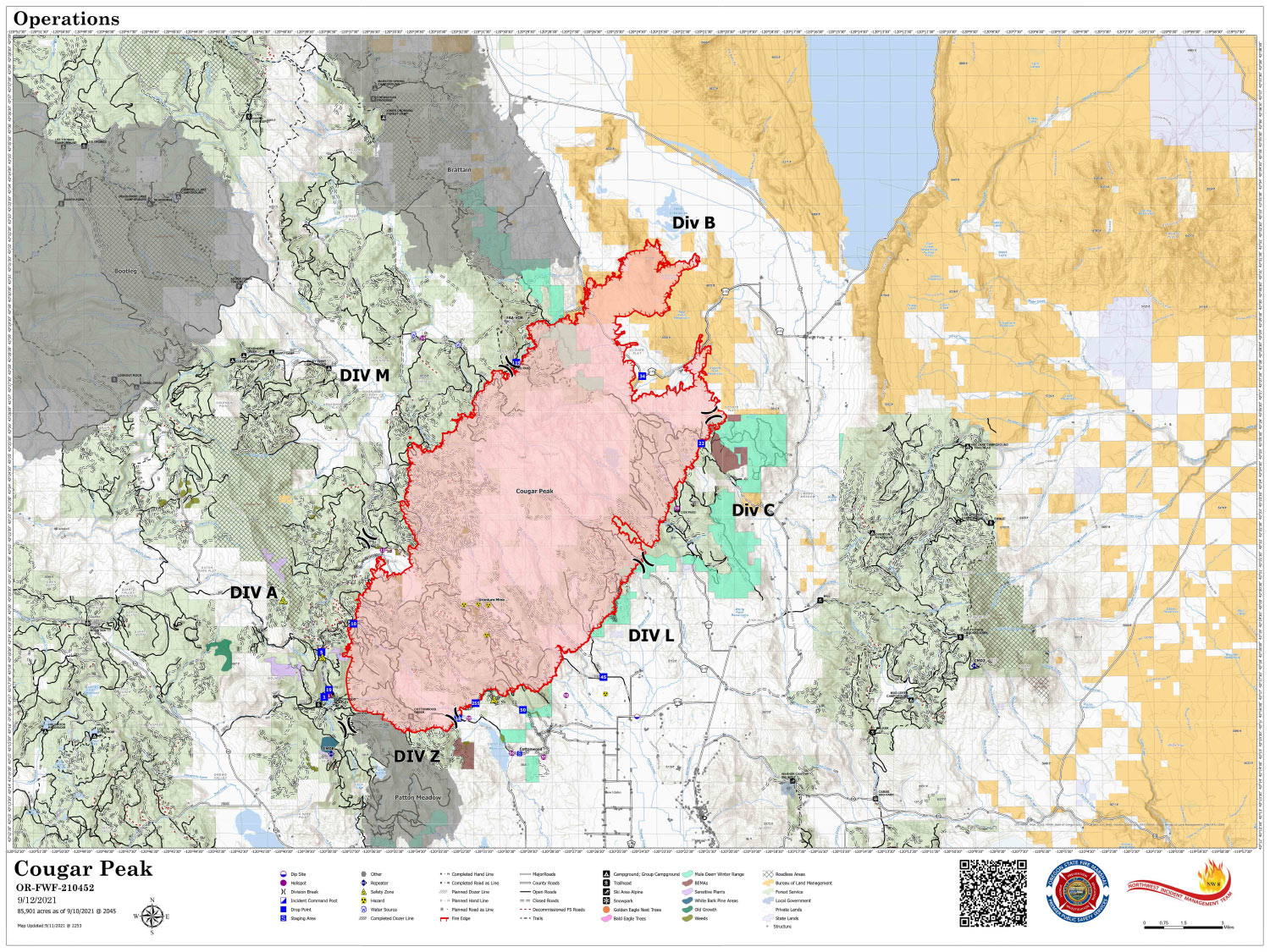
Map Shows Divisions, Uncontrolled Fire Edge, Completed Dozer Lines.
Note: Map is 1,500 Pixels Wide
Note: Click here for Monday's Cougar Peak Fire Updates
Evening Update: Oregon Cougar Peak Fire is at 86,170 Acres, with 6% Containment, and 787 Personnel assigned for Sunday.
Basic Information
| Current as of | 9/12/2021, 9:06:55 PM |
| Incident Type | Wildfire |
| Cause | Undetermined |
| Date of Origin | Tuesday September 07th, 2021 approx. 01:45 PM |
| Location | 15 miles Northwest of Lakeview, Oregon |
| Incident Commander | Kevin Stock/USFS & Scott Magers/OSFM |
| Coordinates | 42.277 latitude, -120.613 longitude |
Current Situation
| Total Personnel | 787 |
| Size | 86,170 Acres |
| Percent of Perimeter Contained | 6% |
| Estimated Containment Date | Tuesday October 05th, 2021 approx. 12:00 AM |
| Fuels Involved |
Timber (Litter and Understory) Brush (2 feet) Medium Logging Slash Predominate fuels are timber, dry climate brush, logging and fuels reduction slash. |
| Significant Events |
Minimal; creeping; torching; smoldering Narrative: Fuels drying up from precipitation event on Friday. Grass and brush fully capable of sustaining moderate to high fire spread. Single to small group torching and low-moderate fire spread potential in the timber fuels models. Excellent humidity recovery has slowed the drying rate of the fuels, but several days of very poor recovery is expected beginning Monday evening. Continued near complete consumption of heavy fuels. |
Outlook
| Planned Actions |
Provide Rural Structure Protection. Reinforce control lines on South and East. Continue construction and prep of contingency lines on west flank. Continue cold trailing in the north end grass and sage fuels. Construct handlines to tie multiple dozer lines together along the east flank. Continue scouting for opportunities. |
| Projected Incident Activity |
12 hours: Minimal fire behavior expected for this period. New starts from the multitude of strikes are expected. Fire behavior consisting primarily of creeping surface fire, single and small group tree torching under protected canopy, and continued consumption of heavy fuels. 24 hours: Minimal fire behavior expected for this period. New starts from the multitude of strikes are expected. Fire behavior consisting primarily of creeping surface fire, single and small group tree torching under protected canopy, and continued consumption of heavy fuels. Grass and brush fully available as the overnight humidity recovery wanes. May pick up some lightning holdovers over the next few days. 48 hours: Timber fuel models support moderate intensity surface fire, single to small group torching, and increased probability of ignition. Torching runs possible today. Continued consumption of heavy fuels. May pick up some lightning holdovers over the next few days. 72 hours: Fuels exposed to several nights of poor day and nighttime humidity recovery will support active surface fire with group torching, high probability of ignition and rapid spread rates. Anticipated after 72 hours: Gusty, prefrontal winds will be present on the fire today. Active surface fire with spread potential in all directions will be possible. Long range spotting with a high probability of ignition is likely. |
Current Weather
| Weather Concerns |
A warming and drying trend yielded highs in the lower to middle 70s with relative humidity dropping into the 20-25% range. Light upslope and up-canyon winds were observed in the afternoon with gusts up to 15 mph. A dry cold front will move through the area Sunday afternoon bringing a period of northwest winds late Sunday afternoon and evening with steady north to northeast wind developing Sunday night. Slightly cooler temperatures but still dry conditions will prevail through Monday along with a steady northerly wind. Another weak cold front is expected to move through late Wednesday but no precipitation is expected. A stronger storm system arrives late in the week with gusty southwest winds returning Friday but increasing chances for rain. |
September 12, 2021 - Cougar Peak Fire Update for Sunday Morning, 86,170 acres with 0% Containment.
Overnight Infrared Flight shows a growth of 206 acres.
Cougar Peak Fire Mid Morning Update
Northwest Incident Management Team 8, Incident Commander, Kevin Stock
Oregon State Fire Marshal Incident Management Blue Team, Incident Commander, Scott Magers
September 12, 2021 – Morning
General Updates: Fire managers continue to work in unified command and are closely coordinating with local agencies, resources, and community partners.
The Oregon State Fire Marshal task forces completed a structural damage assessment yesterday and found four structures and six outbuildings were burned. At this time, the damage assessment team believes all impacted structures have been located, but that number could change as further assessments are completed, or fire behavior changes.
The heel of the fire (south flank) has not changed over the past two days. Cooler weather, light winds and better visibility allowed resources to make substantial progress yesterday to lay hose and start mop up near roads, handlines and dozer lines.
The west side of the fire is in difficult terrain with limited access; natural hazards such as drought weakened trees and powder dry soil.
Crews are evaluating possible opportunities in this area to tie into road systems and establish indirect containment lines. When completed, strategic firing operations will be conducted.
On the head of the fire (north flank) the majority of sagebrush and shrubs in this area were consumed during the intense wind event. Currently, very little heat remains. Firefighters are cold-trailing (feeling with the hand for heat) to reduce the impacts to remaining vegetation on these key grazing lands and further the containment on this portion of the fire.
On the eastern flank, line has been constructed. Short pieces of line remain to be built today to tie together the entire flank.
Behavior: Primary expected fire behavior consists of consumption of light surface fuels under protected canopies and of heavy fuels with single to small group torching. Drought and fire weakened trees will be impacted by the forecasted winds.
Acreage: 86,170
Containment: 0%
Cause: Undetermined
Fire Information: (541) 900-5788 (8:00 am to 8:00 pm)
E-mail: 2021.cougarpeak@firenet.gov
Information Websites:
Facebook: “Cougar Peak Fire 2021”
Air Quality: oregonsmoke.blogspot.com
Weather: More smoke will be moving into the area today so air quality will be diminished. Use caution while outside, especially those with health concerns. Temperatures will be 73-78 degrees in the valleys and 67-72 on the ridgetops degrees with relative humidity of 17-21% in the valleys and 20-24% on the ridgetops. Winds will be light and variable in the morning becoming southwest around noon at 6-9 mph increasing and shifting to the west then northwest by late afternoon at 7-11 mph with gusts around 20 mph.
Resources-793: 1 - type 1 hand crew, 2 - type 2 IA hand crews, 14 - type 2 hand crews, 3 - camp crews, 3 - heavy lift helicopters, 2 - medium lift helicopters, 1 - light lift helicopter, 65 - engines, 14 - dozers, 25 - water tenders, and 2 - masticators.
Evacuations: The Lake County Sheriff’s Office evacuation levels remain at Level 1, Level 2 and Level 3 evacuations in and around the Cougar Peak Fire. For further information please see:
Lake County website https://www.lakecountyor.org/index.php
Lake County Facebook https://www.facebook.com/Lake-County-Oregon-104435824529906
and an interactive map: https://geo.maps.arcgis.com/apps/PublicInformation/index.html?appid=f8a0d8814a67445a9e6bf3485f4fd24f
Temporary Flight Restrictions: A Temporary Flight Restriction is in place over the Cougar Peak Fire. Please consult the Notice to Airman for specifics.
Red Cross Evacuation Shelter: The Lakeview shelter and planned emergency shelter in LaPine are both on standby. If the need arises, staff are available to reopen either shelter.
Wildfires are a No Drone Zone. If you fly, we can’t. Whenever a drone is spotted near the fire, all aircraft are grounded until we can be sure the drone is clear of the area. For more information, visit http://knowbeforeyoufly.org.
An average of 85% of fires in the Pacific Northwest are started by humans. Please continue to do your part and be fire aware, know fire restrictions in areas you are visiting and practice safe summer outings! #OnlyYouCanPreventWildfires
For the latest restrictions and regulations, including Oregon Department of Forestry and federal agencies, visit https://scofmp.org/restrictions.shtml. Make sure to Know Before You Go.
Basic Information
| Current as of | 9/12/2021, 7:16:00 AM |
| Incident Type | Wildfire |
| Cause | Undetermined |
| Date of Origin | Tuesday September 07th, 2021 approx. 01:45 PM |
| Location | 15 miles Northwest of Lakeview, Oregon |
| Incident Commander | Kevin Stock/USFS & Scott Magers/OSFM |
| Coordinates | 42.277 latitude, -120.613 longitude |
Current Situation
| Total Personnel | 793 |
| Size | 86,170 Acres |
| Estimated Containment Date | Tuesday October 05th, 2021 approx. 12:00 AM |
| Fuels Involved |
Timber (Litter and Understory) Brush (2 feet) Medium Logging Slash Predominate fuels are timber, dry climate brush, and logging slash with moisture contents that are at or near record lows. |
| Significant Events |
Minimal; creeping; isolated torching; smoldering Narrative: Primary fire behavior observed consisting of light surface fire under protected canopies, consumption of heavy fuels, and single to small group torching. Low probability of ignition as area recovers from yesterday's wetting rains. |
Outlook
| Planned Actions |
Provide Rural Structure Protection. Reinforce control lines on South and East. Continue cold trailing in the north grass and sage fuels. Scout for opportunities. |
| Projected Incident Activity |
12 hours: Minimal fire behavior expected for this period. Holdover starts from the multitude of strikes are expected. Expected fire behavior consisting primarily of creeping surface fire, single and small tree torching under protected canopy, and continued consumption of heavy fuels. 24 hours: Minimal fire behavior expected for this period. New starts from the multitude of strikes are expected. Fire behavior consisting primarily of creeping surface fire, single tree torching under protected canopy, and continued consumption of heavy fuels. Grass and brush fully available as the overnight humidity recovery wanes. 48 hours: Typical NW flow returns to the fire area. Low to moderate fire behavior is expected in light fuels and brush, continued consumption of 100 and 1000 hour fuels, and additional drying out of smaller diameter fuels in the timber fuel types. 72 hours: Timber fuel models support low to moderate intensity surface fire, single to small group torching, and increased probability of ignition. Wind driven torching runs possible today. Continued consumption of heavy fuels. Anticipated after 72 hours: Timber fuel models support low to moderate intensity surface fire, single to small group torching, and increased probability of ignition. Wind driven torching runs possible today. |
Current Weather
| Weather Concerns |
A warming and drying trend yielded highs in the lower to middle 70s with relative humidity dropping into the 20-25% range. Light upslope and up-canyon winds were observed in the afternoon with gusts up to 15 mph. A dry cold front will move through the area Sunday afternoon bringing a period of northwest winds late Sunday afternoon and evening with steady north to northeast wind developing Sunday night. Slightly cooler temperatures but still dry conditions will prevail through Monday along with a steady northerly wind. Another weak cold front is expected to move through late Wednesday but no precipitation is expected. A stronger storm system arrives late in the week with gusty southwest winds returning Friday but increasing chances for rain. |
Click here for: Oregon Cougar Peak Fire Saturday, September 11, 2021 Updates
