


Note: Click here for Thursday's Cougar Peak Fire Updates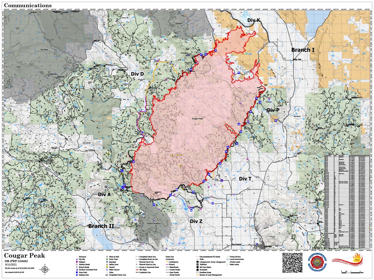
Map Shows Divisions, Uncontrolled Fire Edge, Completed Dozer Lines.
Note: Map is 1,500 Pixels Wide
Note: Click here for Thursday's Cougar Peak Fire Updates
Evening Update: Cougar Peak Fire Wednesday evening update, the fire is now at 87,019 Acres with 6% Containment.
Basic Information
| Current as of | 9/15/2021, 9:19:42 PM |
| Incident Type | Wildfire |
| Cause | Undetermined |
| Date of Origin | Tuesday September 07th, 2021 approx. 01:45 PM |
| Location | 15 miles Northwest of Lakeview, Oregon |
| Incident Commander | Kevin Stock NWIMT8 |
| Coordinates | 42.277 latitude, -120.613 longitude |
Current Situation
| Total Personnel | 845 |
| Size | 87,019 Acres |
| Percent of Perimeter Contained | 6% |
| Estimated Containment Date | Tuesday October 05th, 2021 approx. 12:00 AM |
| Fuels Involved |
Timber (Litter and Understory) Brush (2 feet) Medium Logging Slash Predominate fuels are timber, dry climate brush, logging and fuels reduction slash. |
| Significant Events |
Active; Uphill Runs; Torching; Spotting Narrative: Three consecutive days of low day and poor nighttime humidity, fire activity has picked up. Active surface fire with moderate surface fire with torching runs, high probability of ignition and moderate spotting distance. Spot fires difficult to contain. |
Outlook
| Planned Actions |
Provide Rural Structure Protection. Reinforce, secure, mop up & patrol existing lines in all Divisions. Continue construction and prep of contingency lines on the west flank. Continue cold trailing in the north end grass and sage fuels. Continue to prep for firing operations & scout opportunities to go more direct on west flank. |
| Projected Incident Activity |
12 hours: Timber fuel models support moderate intensity surface fire, single to small group torching, and increased probability of ignition. Torching runs possible today. Continued consumption of heavy fuels. Higher windspeed this period will allow for more rapid spread than the previous few days. 24 hours: Fuels exposed to several nights of poor day and nighttime humidity recovery will support active surface fire with group torching, high probability of ignition and rapid spread rates. Spotting distance decreases for the period as the gusty winds abate. Initiating fire will be difficult to contain. 48 hours: Gusty, prefrontal winds will be present on the fire this afternoon. Active surface fire with spread potential in all directions will be possible. Long range spotting with a high probability of ignition. 72 hours: Frontal winds (potentially gusting to 35-40 mph) could produce extreme rates of spread today on the heels of several days and nights of poor humidity recovery. Torching runs on exposed ridges possible with long range spotting and high probability of ignition. Anticipated after 72 hours: Frontal winds (potentially gusting to 35-40 mph) could produce extreme rates of spread in the morning hours on the heels of several days and nights of poor humidity recovery. Torching runs on exposed ridges possible with long range spotting and high probability of ignition until the arrival of wetting rain in the afternoon hours. |
Current Weather
| Weather Concerns |
West-southwest ridgetop winds ahead of a cool front developed this afternoon with sustained ridgetop speeds of 10-15 mph with gusts less than 25 mph. Sheltered valleys exhibited more of a light diurnal wind pattern. Temperatures were a couple of degrees cooler with highs in the 60s at higher elevations to middle 70s in valleys. Dry conditions continued with poor mid and upper slope recoveries this morning, falling into the 15-20% range this afternoon. The cool front will bring northwest winds to the area this evening, with light remnant north to northeast winds Thursday along with slightly cooler temperatures. Humidity will improve slightly with moderate recoveries expected through Saturday morning with minimum daytime values staying above 15%. A strong Pacific Northwest storm system approaches the area Friday bringing gusty southwest winds and elevated fire weather conditions to Lake County. Even stronger southwest winds arrive Saturday before expected rain moves in late Saturday into Sunday. Wetting rains are likely. Rain chances taper off Monday with cooler than normal temperatures including some freezing temperatures overnight, and lighter winds heading into Tuesday. |
Cougar Peak Fire Update
Northwest Incident Management Team 8, Incident Commander Kevin Stock
September 15, 2021 - Beginning today, one fire update will be provided per day in the morning. Facebook and Inciweb will continue to be updated all day and through the evening. Lakeview Ore. – The Office of the Oregon State Fire Marshal Incident Management Team (OSFM) and task forces will be traveling back to their home agencies today. OSFM would like to thank all of the local agencies and firefighters for the hard work during the initial attack and the ongoing support during the incident. Undoubtedly, the quick and heroic actions of firefighters and local law enforcement saved many lives and protected many homes in the path of the Cougar Peak Fire. During the three deployments that brought OSFM to Lake County this year, the community has been welcoming and the Teams thank them for their hospitality. OSFM is grateful to Northwest Incident Management Team 8 for the partnership and ongoing efforts to continue to manage the fire. Yesterday’s conditions over the fire allowed for many successful planned operations. This included the burnout south of Cox Flat on the southwest corner of the fire. The heavy equipment group continued to make progress constructing contingency lines on the western side of the fire. The burnout completed two days before at Round Mountain had crews mopping up and patrolling. The northern tip of the fire has been cold trailed and very little heat was found. Starting on the northeast corner down the eastern edge of the fire, firefighters are working tirelessly to continue installing hose lays and using helicopters to keep the hotspots and spots found outside the line in check. The southeast corner of the fire is now mopped in up to 100-150 feet and crews continue to mop-up and patrol this crucial anchor point on the fire. Today, firefighter’s priorities will be working the large amount of heat remaining on the eastern side of the fire. Some areas are in difficult terrain and hiking into the fires edge is an arduous task. Air attack will be available over the fire, helping prioritize and coordinate air resources bringing needed water into ground resources via bucket drops. Firefighters did find spots close to the fire line throughout the afternoon yesterday, as downslope winds pushed embers over the line. All resources remain aware to report cattle in the fire area, with location, ear tag and photos to the incident management team. This information will continue to be reported to the livestock owners. Mop-up and patrol will be the mission for crews along the south, southwest, and northern edges of the fire. Heavy equipment will continue to construct contingency lines along the western side. Scouting of the western edge continues, as fire managers are looking for opportunities to construct the lines closer to the fire’s edge. As weather and conditions on the ground allow, fire managers are prepared to conduct small burnout operations to reduce unburned fuels between the fire’s edge and control lines.
Behavior: Overnight minimal fire activity was reported. Today, the relative humidity will again dip into the single digits with 10-15% predicted to be the average across the fire area. The dry air mass in place did not allow for great humidity recovery overnight, which again today is resulting in critically low relative humidity. This may increase fire activity and smoke from the Cougar Peak Fire.
Acreage: 87,019
Containment: 6%
Cause: Undetermined
Fire Information: (541) 900-5788 (8:00 a.m. to 8:00 p.m.)
E-mail: 2021.cougarpeak@firenet.gov
Information websites:
Facebook: “Cougar Peak Fire 2021”
Air Quality: oregonsmoke.blogspot.com
Weather: Temperatures today will be 73-77 degrees in the valley, 67-71 on the ridgetops. A light southwest wind will transition and increase from the west this afternoon across the area before a cool front brings northwest winds this evening, then north winds by midnight tonight. Humidity will be slightly higher this afternoon in the 15-20% range but recoveries this morning in the higher elevations were poor as a dry air mass remains over the region. Humidity will slightly improve tonight along with cooler temperatures.
Resources-890: 2 - type 1 hand crews, 2 - type 2 IA hand crews, 17 - type 2 hand crews, 3 - camp crews, 3 - heavy lift helicopters, 2 - medium lift helicopters, 2 - light lift helicopter, 53 - engines, 19 - dozers, 24 - water tenders, 2 – masticators, and 8 - skidgines.
Evacuations: The Lake County Sheriff’s Office evacuation levels remain at Level 1, Level 2 and Level 3 evacuations in and around the Cougar Peak Fire. For further information please see: Lake County website https://www.lakecountyor.org/index.php Lake County Facebook https://www.facebook.com/Lake-County-Oregon-104435824529906 and an interactive map: https://tinyurl.com/InteractiveEvacMap
Temporary Flight Restrictions: A Temporary Flight Restriction is in place over the Cougar Peak Fire. Please consult the Notice to Airman for specifics.
Red Cross Evacuation Shelter: The Lakeview shelter and planned emergency shelter in LaPine are both on standby and staff are available to reopen either shelter, if the need arises. Wildfires are a No Drone Zone. If you fly, we can’t. Whenever a drone is spotted near the fire, all aircraft are grounded until we can be sure the drone is clear of the area.
For more information, visit http://knowbeforeyoufly.org. For the latest restrictions and regulations, including Oregon Department of Forestry and federal agencies, visit https://scofmp.org/restrictions.shtml. Make sure to Know Before You Go.
Please continue to #knowbeforeyougo! Check for fire restrictions in areas you are going to visit and do your part to stop accidental human caused wildfires. 85% of fire in Oregon are human caused, the greater percentage are all accidental.
September 15, 2021 - Cougar Peak Fire Update for Wednesday Morning, 87,019 acres with 6% Containment.
Overnight Infrared Flight: Interpreted Size: 87,019 Acres a growth of 607 Acres over last flight.
Basic Information
| Current as of | 9/15/2021, 6:09:05 AM |
| Incident Type | Wildfire |
| Cause | Undetermined |
| Date of Origin | Tuesday September 07th, 2021 approx. 01:45 PM |
| Location | 15 miles Northwest of Lakeview, Oregon |
| Incident Commander | Kevin Stock NWIMT8 |
| Coordinates | 42.277 latitude, -120.613 longitude |
Current Situation
| Total Personnel | 858 |
| Size | 87,019 Acres |
| Percent of Perimeter Contained | 6% |
| Estimated Containment Date | Tuesday October 05th, 2021 approx. 12:00 AM |
| Fuels Involved |
Timber (Litter and Understory) Brush (2 feet) Medium Logging Slash Predominate fuels are timber, dry climate brush, logging and fuels reduction slash. |
| Significant Events |
Moderate; creeping; torching; spotting Narrative: Fuels recovering rapidly from the recent rain event. Surface fire moved today from the low category (low intensity, low probability of ignition, infrequent torching) to moderate activity. Aviation assets utilized to assist spot fire suppression. |
Outlook
| Planned Actions |
Provide Rural Structure Protection. Reinforce control lines on South and East. Continue construction and prep of contingency lines on west flank. Continue cold trailing in the north end grass and sage fuels. Construct handlines to tie multiple dozer lines together along the east flank. Continue scouting for opportunities. |
| Projected Incident Activity |
12 hours: Uptick in fire behavior expected. Overnight recoveries diminish significantly over the next 4 days. Moderate surface fire with single and small group torching likely. Light winds for this period limit spotting distance, however probability of ignition will rise each day as daytime humidity also deteriorate. 24 hours: Timber fuel models support moderate intensity surface fire, single to small group torching, increased probability of ignition. Torching runs possible today. Continued consumption of heavy fuels. 48 hours: Fuels exposed to several nights of poor day and nighttime humidity recovery will support active surface fire with group torching, high probability of ignition and rapid spread rates. 72 hours: Gusty, prefrontal winds will be present on the fire today. Active surface fire with spread potential in all directions will be possible. Long range spotting with a high probability of ignition is likely. Anticipated after 72 hours: Frontal winds (potentially gusting to 35-40 mph) could produce extreme rates of spread today on the heels of several days and nights of poor humidity recovery. Crown runs on exposed ridges possible with long range spotting and high probability of ignition. |
Current Weather
| Weather Concerns |
A light north to northeast wind 5-10 mph developed along ridgetops and exposed slopes in the afternoon after a cool front passed through the area last night. Otherwise, light terrain driven winds were observed in most valleys. Temperatures were a few degrees cooler in the 60s and lower 70s with good overnight RH recoveries still dropping around 20% in the afternoon. A few high clouds passed over the area in the early afternoon with slightly better visibility throughout Lake County. Light terrain-driven winds will prevail through Tuesday but a very dry air mass moving into the area will result in poor overnight recoveries in the 30-40% range at higher elevations, dropping to around 10% for many lower valleys in the afternoon. Another weak cold front moves through Wednesday bringing enhanced west to northwest winds and no precipitation. Light winds and dry conditions are expected Thursday with a stronger storm system arriving for the end of the week. Gusty west-southwest winds are expected Friday and Saturday as robust cold Pacific trough moves through the region with increasing rain chances beginning early Saturday morning. |
Click here for: Oregon Cougar Peak Fire Tuesday, September 14, 2021 Updates
