
Slightly above normal temperatures this summer – greatest departure inland.
Near to slightly below normal number of summer thunderstorms.
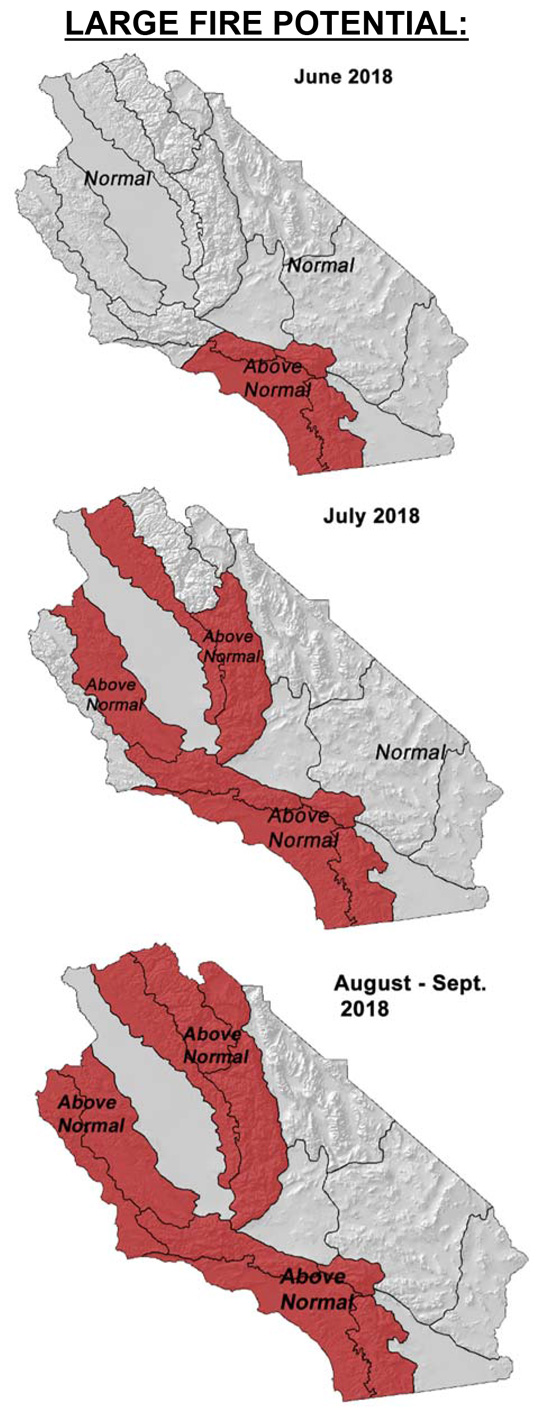
Above normal large fire potential spreading from south to north.
Greatest large fire potential in the Sierra Foothills.
Weather Discussion
June 4, 2018 - Yet another relatively cool and wet period occurred last month as a series of troughs continued to enter California from the Pacific Northwest. The Sierras, especially from Tuolumne County northward, received significant and
 unseasonably heavy wetting rains. Just north of the Geographic Area, persistent rainfall resulted in mudslides which briefly closed highway 395 – an unusual occurrence for May.
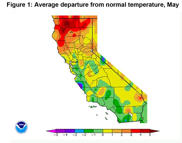
Temperatures remained well below normal over most areas. The temperature disparity between this May’s readings and normal were highest over Southern California (Figure 1, below) which saw the most widespread and long-lived “May Gray” in years. Marine layer stratus kept maximum temperatures 6- 8 degrees below normal along the coast and in many inland valleys along the central coast and in Southern California. Some light precipitation occurred away from the Sierras, but it was too sparse to change fuel moisture much in the long term.
Most long term model guidance had been predicting a very warm spring and summer, but as of late, some ensemble members have seemingly picked up on the pockets of cold water in the Gulf of Alaska and off the Pacific Northwest Coast. The colder water may have played a role in spawning the longwave troughs off the Washington and Oregon coast the past 2-3 months. If so, this pattern may continue to some degree over the next few weeks. The offshoot of this pattern for our area would be a persistent southwesterly flow aloft with onshore pressure gradients at the surface. This pattern would keep coastal areas cooler with more marine layer stratus coverage than usual. The effects of this would be less pronounced inland, and temperatures may be closer to normal over the valleys, foothills and deserts.
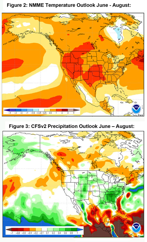
The NMME (North American Multi-Model Ensemble) bear this out with expected temperature anomalies higher over the eastern part of the state (Figure 2, below). The southwesterly flow aloft may keep most of the higher relatively humidity associated with the monsoon, further east over the Southwest into the Central Rockies. Below average levels of thunderstorms may result again this summer, especially over Southern California, with this pattern (Figure 3, below). But last year was one of the quietest monsoon seasons in recent memory with very few days with convection in the Sierras. While this had the fortunate effect of removing an important source of ignition from the district, fuels remained extremely dry in the high country all summer with no recovery of subsoil moisture from wet thunderstorms.
This summer will likely bring some lightning to the Sierras, but at a slightly lower rate than usual. There may be a few dry lightning episodes possible, which has not been much of an issue across South Ops’ area in recent years. Unfortunately, there is no reliable long term guidance for forecasting the proportion of dry vs wet thunderstorms on a seasonal basis.
Fuels and Drought Outlook
The cooler than average temperatures allowed fuel moisture to drop at a slower than normal rate this spring – especially compared to last year. In 2017, the wet weather of the winter suddenly ended in the spring which resulted in the heavy grass crop and new fine fuel growth to dry quickly. This unfavorable cycle helped drive the extremely active spring fire season. The lack of storms last year also allowed fires to spread, unchecked by the weather, into high elevations several weeks early. Only the highest alpine elevations with a heavy snowpack were spared wildfire activity last year.
This year is quite the opposite in terms of fuel conditions. This winter started off very dry (recall the large fires over Southern CA last December), but finished on a wet note with above normal precipitation occurring March- April over most areas. The rains this year arrived just in time for grasses to avoid curing over many areas, but compared to last year, the grass crop is patchy and less dense. At higher elevations, although subsoil moisture is favorable, there is much less snowpack heading into the summer. Most areas will see meltout soon which may allow fires to spread into alpine areas a few weeks early.
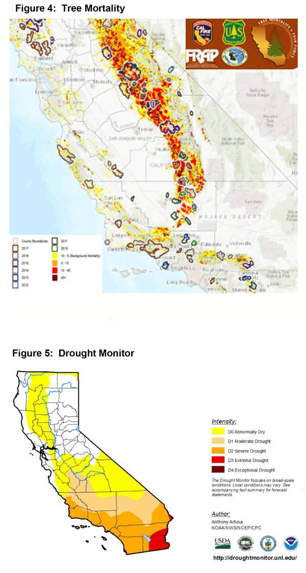
The combination of a late winter wet period and the expectation of near to slightly above normal temperatures may allow large fire potential to spread from south to north in a slower march than last year. A sudden spike in fire activity is no longer expected in the late spring/early summer period. A more favorable weather pattern may keep resource demand a bit lighter compared to last year with activity not spread out spatially as what was experienced in 2017. The greatest threat of starts this summer may come in the form of thunderstorms in the Sierra Foothills as there is significantly more acres of trees impacted by the bark beetle infestation than in 2016 (Figure 4 below) – which was the last time this area saw much convection. Therefore, we expect the Sierra Foothills to see the greatest threat of large fires this summer. The drought status across the southern 2/3rds of the state should show only minor changes the next few months as rainfall is normally light during the June-September time period.
Source: Predictive Services