
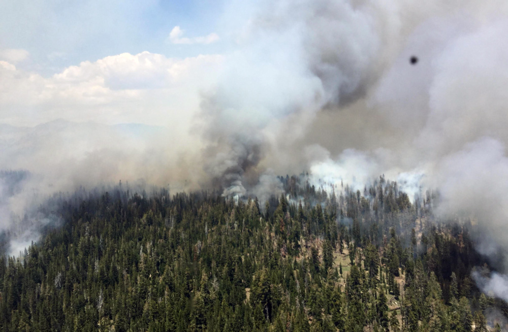
 Burn operations are made safer and more efficient by using aerial (helicopter) ignitions in areas with poor access on the ground. Unstable atmospheric conditions allowed for good smoke dispersion late into the afternoon. Credit: Sierra National Forest - Inciweb
Tuesday Update (see smoke maps below): Air quality in Mammoth Lakes and the surrounding areas is currently being affected by smoke traveling over the Sierra Nevada from the County Fire in Yolo County. The Lions Fire is showing little growth as firefighters work to increase containment. Smoke production within the burned area has decreased dramatically over the past week and is expected to continue to decrease.
July 3, 2018 - The Lions Fire is currently 3,850 acres and 50% contained. Yesterday’s burn-out operations were effective with good fuel consumption, resulting in strengthened fireline and reduced vegetation and dead and down wood throughout the burned area. Crews plan to complete the remainder of burn-out operations by hand today.
Smoke production from the Lions Fire is expected to be reduced today and will continue to decrease throughout the coming week. Fires elsewhere in the region may affect air quality in the coming days.
Nearly 20 miles of fire perimeter have been mapped for containment with handline or natural barriers, and air resources have logged approximately 680 flight hours. Operations are drawing down, and several crews and helicopters have been released to respond to other fires, regionally and nationally. Five crews currently remain on the fireline and are focusing their efforts on the northern part of the fire.
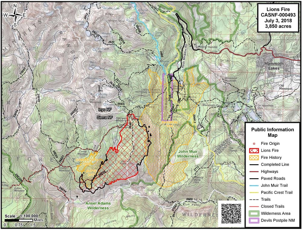
This lightning-caused fire was detected in early June and is located in the Ansel Adams Wilderness. It is located primarily in the Stairway Creek drainage, north and west of the Middle Fork of the San Joaquin River.
The following National Forest System Trails near the burned area have been temporarily closed: Sierra National Forest Trails No. 26E01 (Mammoth Trail) to the Inyo NF Boundary, 26E14, 26E56, and 26E46 from the Inyo NF boundary. Inyo NF trail closures include 26E01 from the Sierra NF to 2601 junction, and 2601 from the boundary of the Inyo NF and Devils Postpile National Monument (King Creek Trail). Trail closures will remain in place until fire management staff determines that it is safe to reopen the area for recreational use.
Shuttles to Devils Postpile National Monument and Reds Meadow Valley are running, and trails there are open. The Pacific Crest Trail and the John Muir Trail are open. Visitors should expect smoke impacts of variable intensity.
Air quality forecasts are available at https://airnow.gov/index.cfm?action=topics.smoke_wildfires
For more information about smoke conditions in the area, visit webcams at www.mammothmountain.com and the alert tab at nps.gov/DEPO
For more information, call (760) 582-5203.
Source: Inciweb
NWS Reno Surface Smoke Forecast Reno National Weather Service smoke forecast map for the state of California. Note smoke impacts crossing the Sierra Nevada in the Mammoth Lakes area.
Smoke from the County Fire and Lions Fire 7-3-2018
 Mammoth Lakes and the surrounding areas are experiencing increased smoke impacts from the County Fire in Yolo County, while smoke output from the Lions Fire has decreased.
Basic Information
|
Current as of |
7/3/2018, 6:58:45 AM |
|
Incident Type |
Wildfire |
|
Cause |
Lightning Strike |
|
Date of Origin |
Monday June 11th, 2018 approx. 12:00 PM |
|
Location |
7 miles southwest of Mammoth Lakes |
|
Incident Commander |
Stephen Fillmore, Type 3 IC |
|
Incident Description |
The Fire Is Burning At Approximately 6000- 8000' In Red Fir (compact) Needle Cast And Brush As Well As Heavy Blowdown From 2011 Wind Event. |
|
Coordinates |
37.571 latitude, -119.118 longitude |
Current Situation
|
Total Personnel |
286 |
|
Size |
3,850 Acres |
|
Percent of Perimeter Contained |
50% |
|
Estimated Containment Date |
Saturday July 14th, 2018 approx. 12:00 AM |
|
Fuels Involved |
Timber (Litter and understory) Brush (2 feet) |
|
Significant Events |
Moderate Flanking Single tree torching |
Outlook
|
Planned Actions |
Crews will continue to improve and burn out control lines utilizing natural barriers to the extent possible. Utilize helicopter water drops to check fire in inaccessible terrain north and west of San Joaquin River. Continue burnout operations to secure northeast side. |
|
Projected Incident Activity |
Flanking to west especially in thermal belts with poor recoveries and in dry fuels. |
|
Remarks |
2,225 acres on the Sierra National Forest; 1,625 acres on the Inyo National Forest. |
Current Weather
|
Weather Concerns |
Warming with gusty W-SW winds are expected this week. |
Air Quality Report 7-3-2018
Fire
Several more days of dry southwest flow will continue to test containment lines. Heavy dead and down fuels are highly susceptible to ember cast; isolated interior torching will remain a concern with spotting potential each afternoon and evening.
Smoke
Better air quality as fire burns remaining fuel inside containment lines. Smoke will be visible near the fire area. Greatest impacts will be in the evening hours. Expect improved conditions each day as smoke production decreases.
Weather
Dry and breezy conditions are expected again for Tuesday and for the rest of the holiday week. Winds will be slightly stronger on Wednesday and Thursday as low pressure pushes closer to Northern California.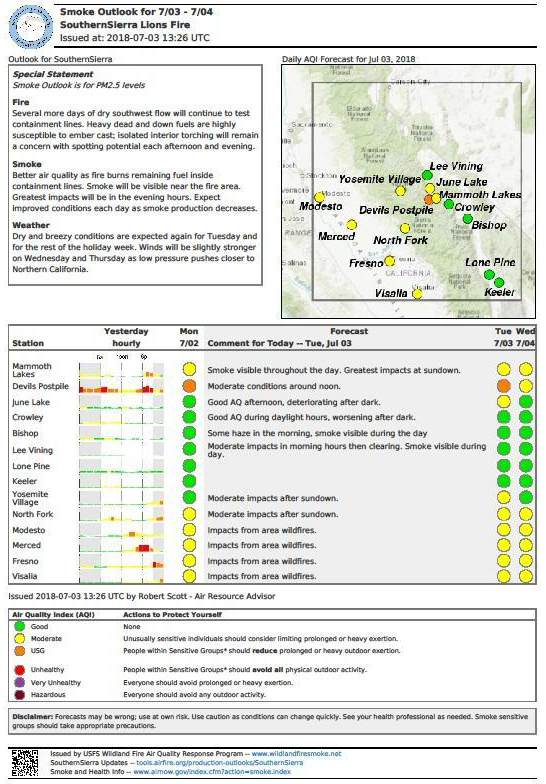
NOTE: Maps represent approximate information.
 Source: Inciweb
Related information:
Sierra National Forest Lions Fire Monday Evening Updates
Sierra National Forest Lions Fire Update for Tuesday, June 26, 2018
Sierra National Forest Lions Fire Update for Wednesday, June 27, 2018
Sierra National Forest Lions Fire Update for Thursday, June 28, 2018
Sierra National Forest Lions Fire Update for Friday, June 29, 2018
Sierra National Forest Lions Fire Update for Saturday, June 30, 2018
Sierra National Forest Lions Fire Update for Sunday, July 1, 2018
Sierra National Forest Lions Fire Update for Monday, July 2, 2018