
Statistics
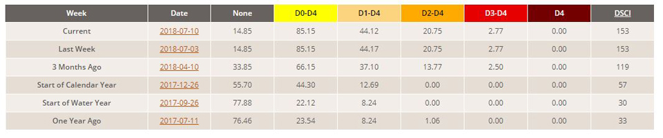
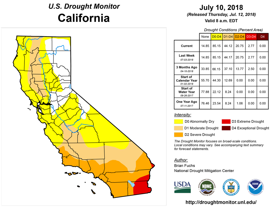
California and National Drought Summary for July 10, 2018
Summary
July 13, 2018 - An active summer pattern continued over the central and northern Plains and into the upper Midwest, with several areas seeing well above normal precipitation associated with thunderstorms. Along the Gulf Coast from Texas to Florida, precipitation was plentiful and widespread as ample moisture continued to be transported into the region. The precipitation along the Gulf also helped to keep temperatures 1-3 degrees cooler than normal for this time of year. Some monsoon activity started up in the Southwest with some scattered precipitation while most of the rest of the West remained warm and dry with an increase in fire danger and active fires throughout the region.
Northeast
Temperatures were near normal to slightly above normal in New England, where departures were 2-4 degrees above normal for the week. Precipitation was spotty at best as most areas recorded less than half the normal rain for the week, with Pennsylvania recording the most. The continued warm and dry pattern over the short term allowed for an expansion of the abnormally dry conditions over central New York, southeast Massachusetts, Rhode Island, and northern Connecticut. Moderate drought was introduced over northeast New York and portions of northern New York this week. It was noted that dryness, along with the heat, has started to impact the region into the Mid-Atlantic. No changes were made this week but local observations stated that the region is primed for flash drought development if rains don’t materialize.
Southeast
Typical spotty summer precipitation has been the theme for the region. Pockets of dryness have developed in the region but cooler than normal temperatures have also helped keep drought from developing. Abnormally dry conditions have expanded in the Carolinas this week with more of North and South Carolina experiencing abnormally dry conditions. Minor improvement to abnormally dry conditions over western and southern Alabama and abnormally dry conditions were eliminated in Tennessee.
Midwest
Warmer than normal temperatures dominated the region, with the Upper Midwest having the greatest departures with temperatures 4-6 degrees above normal. It was also a fairly dry week over the region with only spotty precipitation over portions of central Illinois into Indiana. Minnesota into northwest Iowa recorded the most precipitation during the week as the active weather that impacted the northern Plains drifted east. Rapidly changing conditions in Michigan allowed for a widespread expansion of abnormally dry conditions in Lower Michigan as well as the eastern edge of the Upper Peninsula. Moderate drought was introduced this week into eastern Michigan as flash drought conditions are developing rapidly. Abnormally dry conditions were eliminated over most of northern Minnesota while they expanded in southeast Iowa, with a slight expansion of moderate drought there as well. Abnormally dry conditions were introduced into portions of western Kentucky where conditions have been dry over the short term. In Missouri, extreme drought was introduced this week into the northern portions of the state. Dryness on multiple timescales as well as local impacts being reported help guide this introduction. Severe drought was also introduced in southwest Missouri and expanded in northwest Missouri while moderate drought was expanded over northeast Missouri.
High Plains
An active thunderstorm pattern helped to bring ample precipitation to North Dakota, northern South Dakota, central and eastern Nebraska, and portions of western Kansas. The precipitation last week along with recent rains has allowed for improvements in the Dakotas. Severe drought was eliminated from both North and South Dakota while abnormally dry and moderate drought conditions contracted as well. All of the abnormally dry conditions were eliminated from northwest South Dakota and southwest North Dakota. Eastern Kansas remained dry and severe drought expanded through northeast Kansas and was introduced into southeast Kansas while moderate drought expanded as well. Southwest Kansas had a full category improvement to drought conditions this week as the recent wetness has helped improve drought in this part of the state. In Nebraska, the recent rains in June and early July did not impact all of the state equally and portions of southern Nebraska are starting to show lingering impacts due to dryness going back to the autumn of 2017. This area will need to be monitored closely for development in the coming weeks.
Portions of southeast Colorado improved this week in response to the recent wet pattern, but a new area of exceptional drought was introduced in eastern Colorado as conditions have been rapidly worsening in both the short and long term.
South
The southern portions of the region had the most precipitation as the Gulf Coast continued to be wet and also cooler where the most rain occurred. Areas of eastern Oklahoma and northern Arkansas into northern Mississippi continued to remain dry with some short-term impacts starting to develop. Areas of the Oklahoma and Texas panhandles had improvements this week as the rains continued in the short term and continue to improve the longer-term issues that allowed exceptional drought to be removed in Oklahoma. Severe drought was introduced into northeast Oklahoma, and abnormally dry and moderate drought were also expanded. Moderate drought and abnormally dry conditions were also expanded in northern and central Arkansas and into eastern Mississippi. Improvements were made in southern Louisiana where the most recent rains helped in the short term.
In Texas, conditions improved along the Gulf Coast and Rio Grande regions where exceptional drought was eliminated and extreme drought contracted. Northeast Texas also saw some improvements to moderate and severe drought while abnormally dry conditions were also improved in east Texas into Louisiana. In central Texas, severe drought was introduced and moderate drought expanded, and extreme drought was expanded in northern Texas. West Texas had moderate drought introduced, while other areas had improvements to abnormally dry and moderate drought conditions.
West
Most of the region was dry this week and also recorded temperatures that were 3-6 degrees above normal. Portions of Arizona, New Mexico, southern Utah, and eastern Nevada did see some monsoon activity with scattered precipitation in both states. The hot and dry conditions have allowed for quite a rapid expansion of drought in portions of Utah and Colorado. A full category degradation was introduced over much of eastern Utah and western Colorado, bringing most of the area into exceptional drought conditions. Moderate drought was expanded to most of northwest Colorado while moderate drought and abnormally dry conditions migrated to the east in Colorado to include the Denver area. Moderate drought was introduced into northwest Montana and the panhandle of Idaho while abnormally dry conditions expanded over northeast Washington. Moderate drought and abnormally dry conditions were also expanded over central Oregon and Washington because of the short-term issues combined with dryness through the winter. Abnormally dry conditions were also expanded in southwest Wyoming. Eastern New Mexico did have some improvement where exceptional drought was retracted in the northeast portion of the state, and some improvements were also made along the border with Texas.
Alaska, Hawaii, and Puerto Rico
Puerto Rico had abnormally dry conditions improve over the eastern portion of the island. Abnormally dry conditions were expanded on the Big Island of Hawaii while short-term moderate drought was introduced on Maui and Molokai. There were no changes for Alaska this week.
Looking Ahead
Over the next 5-7 days, the active precipitation pattern is expected to continue over the Southwest and into southern Colorado. The central Plains and Upper Midwest as well as areas of the Southeast also should see widespread rain. Temperatures will be warmest over the West and Great Basin as well as over most of the Midwest, Mid-Atlantic, and Northeast, with departures 6-9 degrees above normal in the West and 3-6 degrees above normal over the East.
The 6-10 day outlooks show that greatest probabilities of above-normal temperatures are in the West and also from the southern Plains through the Midwest and across much of the East, while much of the central Plains and Alaska have the best probabilities of below-normal temperatures. The greatest probabilities of above-normal precipitation are from the Southwest into the central Plains and into the Mid-Atlantic and New England. The highest probabilities of below-normal precipitation are in the Pacific Northwest and northern Rocky Mountains, the northern Plains and much of Texas.
Author(s):
Brian Fuchs, National Drought Mitigation Center
Dryness Categories
D0 Abnormally Dry—used for areas showing dryness but not yet in drought, or for areas recovering from drought.
Drought Intensity Categories
D1 Moderate Drought
D2 Severe Drought
D3 Extreme Drought
D4 Exceptional Drought
Drought or Dryness Types
S Short-Term, typically less than 6 months (e.g. agricultural, grasslands)
L Long-Term, typically greater than 6 months (e.g. hydrologic, ecologic)
Source: National Drought Mitigation Center