
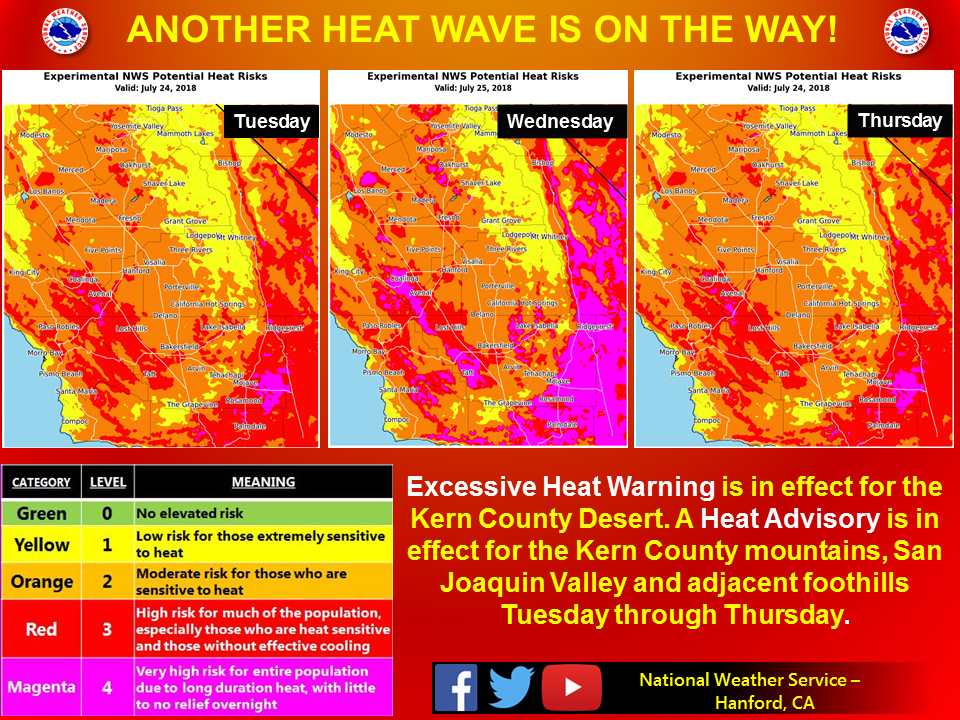
July 24, 2018 - The National Weather Service Hanford office reports a Heat Advisory is in effect for the San Joaquin Valley and adjacent foothills.
Hot weather will return for the entire San Joaquin valley, Sierra Foothills (including the Ferguson Wildfire Operation Area), and the Kern County desert Tuesday through Thursday.
High temperatures will range from 103 to 108 degrees in the San Joaquin Valley and lower foothills and between 105 and 115 degrees in the Kern County desert each of these days.
Wednesday looks as though it will carry the greatest potential heat risk.
Prolonged exposure to hot weather can lead to heat stroke or heat exhaustion.
To avoid heat related illness, limit your time outdoors during the hottest time of the day, stay hydrated, apply sunscreen, and wear light colored, loose fitting clothing.
Never leave people or pets inside an enclosed vehicle, temperatures inside an enclosed vehicle can soar to deadly levels in a matter of minutes!
Heat AdvisoryURGENT - WEATHER MESSAGE National Weather Service Hanford CA 1055 PM PDT Mon Jul 23 2018 West Central San Joaquin Valley-East Central San Joaquin Valley- Southwestern San Joaquin Valley-Southeastern San Joaquin Valley- Mariposa, Madera, and Fresno County Foothills- Tulare County Foothills-Kern County Mountains- Including the cities of Los Banos, Coalinga, Mendota, Fresno, Hanford, Lemoore, Avenal, Corcoran, Bakersfield, Visalia, Oakhurst, Mariposa, Springville, Three Rivers, Tehachapi, and Lake Isabella 1055 PM PDT Mon Jul 23 2018 ...HEAT ADVISORY REMAINS IN EFFECT FROM 1 PM TUESDAY TO 11 PM PDT THURSDAY... * TIMING...Tuesday afternoon through Thursday evening. Highest temperatures will occur on Wednesday. * TEMPERATURE...High temperatures will range from 103 to 108. Low temperatures in the lower 70s to low 80s. * IMPACTS...Heat related illnesses such as heat exhaustion and heat stroke will be possible. Stay hydrated and take more frequent breaks from activities. People most vulnerable include those who are spending lots of time outdoors...those who do not have air conditioning...young children...the elderly...and those with chronic ailments. PRECAUTIONARY/PREPAREDNESS ACTIONS... A Heat Advisory means that a period of hot temperatures is expected. The combination of hot temperatures and high humidity will combine to create a situation in which heat illnesses are possible. Drink plenty of fluids, stay in an air-conditioned room, stay out of the sun, and check up on relatives and neighbors. Take extra precautions, if you work or spend time outside. When possible, reschedule strenuous activities to early morning or evening. Know the signs and symptoms of heat exhaustion and heat stroke. Wear light weight and loose fitting clothing when possible and drink plenty of water. To reduce risk during outdoor work, the occupational safety and health administration recommends scheduling frequent rest breaks in shaded or air conditioned environments. Anyone overcome by heat should be moved to a cool and shaded location. Heat stroke is an emergency, call 9 1 1.
  Area Forecast Discussion
  National Weather Service San Joaquin Valley - Hanford CA
  312 AM PDT Tue Jul 24 2018

  .SYNOPSIS...
  High pressure moving into the region will bring a return of above
  average temperatures by mid-week. Dry conditions will continue,
  with just a few afternoon thunderstorms possible near the Sierra
  crest areas for the next few days.

  &&

  .DISCUSSION...
  Today looks to be hot day for the San Joaquin Valley as upper
  level high pressure once again builds over our area. High
  temperatures today look to be a few degrees warmer than yesterday
  in the lower elevations of the SJV, which is why a heat advisory
  is in place for today. Afternoon highs are expected to be in the
  102-105 Fahrenheit range for most of the valley. Like the last few
  days, showers and thunderstorms appear to be possible over the
  High Sierra, and will likely start between 1-2 PM PDT and persist
  through the late afternoon and evening hours per hi-res model
  guidance. Tomorrow looks to be even warmer than today by a degree
  or two, but only a slight chance of thunderstorms of the Sierra
  tomorrow since high pressure will limit some convection. The
  westward progressing ridge of high pressure will produce a near
  surface inversion that could increase smoke density near any fires
  occuring for the next couple of days.

  The possibility of showers and thunderstorms will decrease after
  Wednesday, so the main story will be the heat forecast for
  central California. The heat advisory is in place through Thursday -
  where highs are expected to be in the 103-108 range for most of
  the valley - but Friday also looks to be quite warm too with highs
  only a degree or two less than Thursday. This weekend, a low
  amplitude mid level disturbance will give the northern part of the
  valley some marine air that will take some edge of the hot
  temperatures by a couple of degrees in Merced County, but for the
  most part, we stay above average through the weekend. The latest
  6-10 and 8-14 day temperature outlooks from the Climate Prediction
  Center have us progged to be above average, which is in agreement
  with the courser resolution models - so current thinking is that
  the 21 consecutive day record of 100 degree or higher temperatures
  in Fresno could be broken by Friday of this week.

  &&

  .AVIATION...
  Areas of MVFR visibility in smoke will continue in the vicinity of
  the Ferguson Fire in Mariposa County for at least the next 24 hours.
  A chance of thunderstorms will be possible near the Sierra crest
  between 20z and 04z Wednesday. Otherwise, VFR conditions will
  prevail over the central California interior during the next 24
  hours.

  &&

  .AIR QUALITY ISSUES...
  Air Quality Alert for Merced, Madera, Fresno, and Tulare Counties
  due to smoke impacts from the Ferguson Fire.

  &&

  .CERTAINTY...

  The level of certainty for days 1 and 2 is high.
  The level of certainty for days 3 through 7 is high.

  Certainty levels include low...medium...and high. Please visit
  www.weather.gov/hnx/certainty.php for additional information
  an/or to provide feedback.

  &&

  .HNX Watches/Warnings/Advisories...
  Heat Advisory from 1 PM this afternoon to 11 PM PDT Thursday
  CAZ089>095.

  Excessive Heat Warning from 1 PM this afternoon to 11 PM PDT
  Thursday CAZ098-099.
Source: NWS