


Statistics
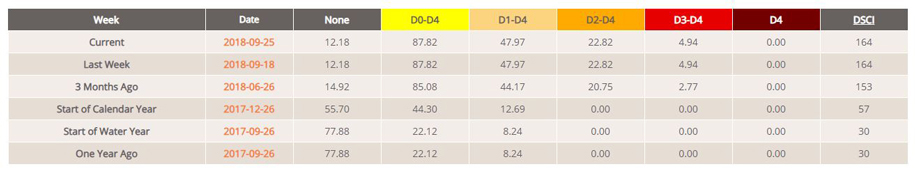
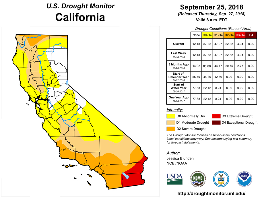
California and National Drought Summary for September 25, 2018
Summary
September 27, 2018 - The combination of energetics from northern Mexico lifting toward the Southern Rockies/Great Plains and enhanced moisture from the remains of a tropical depression led to heavy precipitation events across the south-central U.S., particularly notable as a frontal zone stalled. Significant rain fell across much of the South, leading to much improved drought conditions in many areas. In fact, several regions across the U.S. received at least double (or more) of their typical precipitation for this time of the year over the past week, including the far Pacific Northwest, eastern Montana to northern Nebraska and Iowa and western Wisconsin, southwestern Arizona into northwestern New Mexico, and a large swath encompassing much of Texas northeastward to southern New Hampshire, part of which was from the remnants of Florence, now classified as the second wettest storm of the past half century to impact the U.S. Parts of the Southeast and most of the West were dry and drought conditions spread or worsened in several regions.
Northeast
Much of southern New England received a soaking rainfall when the remnants of Florence moved through the area, although there was a sharp precipitation gradient. In Massachusetts and Rhode Island, the abnormally dry (D0) area decreased toward the south, in Plymouth and Bristol Counties in Massachusetts and Washington County in Rhode Island. Month-to-date precipitation there has been 100 to 200 percent of normal, and precipitation over the past two months ranges from about 90 to 150 percent of normal. Area streams and rivers received a significant boost from the rainfall. On the other side of the precipitation gradient, northern New York was much drier, with continuing above-average temperatures. Abnormally dry conditions were extended to the north/northeast in Jefferson and St Lawrence Counties, and eastward along the Canadian border into northeastern Wayne County. A small area of D0 also grew westward into Monroe County.
Southeast
Much of the Southeast remained drought free, with the exception of southern South Carolina, and parts of Georgia and Alabama, areas that have missed out on surrounding heavy precipitation events. In these regions, temperatures reached into the 90s over the past week and beyond, exacerbating the dryness. Both abnormally dry (D0) and moderate drought (D1) conditions spread across central and southeastern portions of Georgia, into an adjoining area in the South Carolina Lowcountry. Savannah (Georgia) has received 13.05 inches of rain since June 1, just 60% of its normal precipitation, the driest such period since 1990 and seventh driest since records started there in 1871. Alabama also continued to experience dryness in the north, where D0 and D1 were expanded slightly in the northwest, but also some in the southeast, encompassing parts of Bullock, Macon, and Russell Counties, where precipitation deficits are apparent over the last month.
South
A stalled front brought significant rainfall to much of the South, providing several inches of rain across the region, including drought-stricken areas. The system brought normal conditions back to all of northwestern Tennessee, where 3 or more inches of rain fell over the past week. The system also brought enough rainfall to alleviate much of the abnormal dry (D0) and moderate drought (D1) conditions in southern and central Tennessee where several inches of rain also fell. In Mississippi, D0 continued to shrink across the north central part of the state. Unfortunately, areas along the Mississippi/Alabama border missed out on the most significant precipitation and so D1 expanded here. In Louisiana, significant rain fell right where it was needed across the north to reduce drought impacts while providing a seemingly endless moisture feed from the Gulf, fueling daily convection across the rest of the state. Most of the D1 was eliminated in the northwestern part of the state. A 2-category improvement -- from severe drought (D2) to D0 -- across southern Bossier and northern Bienville Parishes was warranted, as these areas received widespread totals of 3 to 4 or more inches, which actually resulted in flash flooding. In Arkansas, this week’s wet weather allowed for more trimming of D0 in both the north and south. The areas of D1 remain in the southern part of the state though, due to deficits dating back several months which have yet to be overcome. Southern and eastern Oklahoma into much of Texas also saw widespread improvements across much of the state, including a few areas of 2-category improvement related to the massive downpours that alleviated any dryness and related drought impacts. While 3 inches or more was common, some isolated areas received more than a foot of precipitation. Some areas of southwestern Texas, however, did not receive much rain, and areas of D0 to D2 spread, namely from eastern Hudspeth County to Brewster County along the U.S./Mexican border.
Midwest
Western Kentucky and southeastern Missouri received around 1 to 3 inches of rainfall over the past week, bringing a lingering area of abnormally dry (D0) conditions back to normal. Additionally moderate drought (D1) across the southern border slightly improved. This week’s rain was not adequate across central Missouri, however, and D1 spread a bit west in Cedar and Barton Counties and northeastward across Benton County, connecting to the existing D1 area in Morgan County. Abnormally dry conditions along the Missouri/Kansas border also spread west to encompass more of Bourbon and Crawford Counties. Although no changes were made this week in northeastern Missouri, impacts remain notable. An extension agronomist in Gentry County reported that “the rains came slow enough that there was virtually no runoff into ponds to raise water levels....Some producers are still hauling water or are relying on rural water for their cattle. Grass did start to grow again but the ground has quickly dried out in the past couple of weeks.” Temperatures climbed into the 90s in this county and across the state this past week.
High Plains
As summer comes to a close and fall begins, many areas across the High Plains continue to experience dry conditions. In eastern Kansas, extreme drought (D3) was extended into the northern half of Osage County as well as southwestward into northeastern Marion County. Extreme drought was also introduced in Eddy County in east central North Dakota, with adjoining extreme (D2) and moderate (D1) drought each extending slightly farther south to southern Foster County. These counties have each received less than 25 percent of their typical precipitation over the past two months. Among some of the local observances: “soybean yields are disappointing. Corn harvest has started, more than a month earlier than normal. Grasshoppers are thick in some areas of the county, damaging some late season crops. Some producers have started feeding their cattle, which typically does not happen until first snowfall. Pastures are bare and water sources have dried up. Producer are having to haul cattle home from pastures”. In northern Wyoming, a small patch of D0 was introduced to northern Campbell County, and a larger swath was introduced just to the south from Johnson County (Wyoming) east to Shannon County (South Dakota). These areas have also seen below-average precipitation over the past two months, with Mt Rushmore the fifth driest in its record for this period.
West
An upper low dropping down from the Gulf of Alaska sparked widespread precipitation across western Washington in the Pacific Northwest, helping lead to improvements along the coastal region to just across the Oregon state line. With high temperatures generally in the mid to upper 60s, up to 4 inches of rain fell over the bullseye of severe drought (D2) in north central Montana along the Canadian border this past week, improving conditions here. In Utah, Idaho, and Nevada, however, little to no precipitation fell and temperatures remained above average. Severe drought expanded across southern Idaho and southward through Elko into White Pine County in northeastern Nevada and the remaining areas of Box Elder, Tooele, Juab, and (most of ) Millard Counties in neighboring Utah. A local report from Tooele County notes a range of poor conditions, from extreme fire danger to low ponds to pulling herd off the rangeland to near-empty reservoirs. This region has received little rain since April and are below-average at the beginning of the fall season, when the region should see a pick up in precipitation. Also in northern Utah, extreme drought (D3) was expanded farther west in Box Elder County. Across Utah, 66 percent of pasture and range land were rated poor or very poor for the period ending September 23, while 68 percent of the topsoil moisture rated poor to very poor for the same period, according to the U.S. Department of Agriculture. Conditions also degraded in other areas. Extreme drought was expanded northward over southeastern Utah, northwestern Colorado, and slightly into Carbon County in southern Wyoming. With only one week left in the water year, the gauge on the San Juan River near Bluff, Utah, is on course to break its 92-year record for lowest accumulated discharge. Severe and moderate (D1) drought also expanded slightly along the Continental Divide. With a lack of precipitation in August and September to date, abnormal dryness (D0) was expanded to the north and east in northeastern Colorado. Exceptional drought (D4) expanded in southwestern Colorado and northern New Mexico due to high temperatures, in addition to the continuing lack of precipitation.
Alaska, Hawaii, and Puerto Rico
Conditions continued to worsen across Alaska’s southern panhandle, where precipitation has been below average for more than a year. In this region, most of the area of moderate drought (D1) has degraded to severe drought (D2). Low precipitation, both recent and over the long term, has created major impacts. The Metlakatla Indian Community (MIC) on Annette Island is at risk of losing power. Due to extremely low water levels, the MIC had to shut down turbines at both lakes that supply the community with hydroelectric power.
Recent precipitation across the Hawaiian Islands continues to help improve conditions. This week, improvements were made in Molokai, Maui, and the Big Island. Maui and the Big Island now the only two islands experiencing lingering dryness and drought.
Up to 2 inches of rain fell across southwestern Puerto Rico this past week, adding to recent rainfall received in the area. Conditions improved to normal in this part of the territory.
Looking Ahead
Over the week beginning Tuesday September 25, most of the contiguous U.S. is expected to receive at least some precipitation, with 2 or more inches predicted across east central Wisconsin, parts of New York and Massachusetts, and a swath from south Texas and southern Louisiana into much of eastern Mississippi, central and northern Alabama, central and southeastern Tennessee, northwestern Georgia, and western North Carolina. Areas not expecting any precipitation are all areas currently experiencing some level of drought, including eastern Washington into north central Oregon, southern California, most of Nevada, southern Idaho, and eastern Colorado. Looking further ahead at NOAA’s Climate Prediction Center (CPC) 6-10 day Outlook (September 30 - October 4), above-normal temperatures are favored across all of Alaska, along with most of the southern and eastern contiguous U.S. Below-normal temperatures are favored over central and northern California extending eastward into Wisconsin. A projected deep trough over the Bering Sea indicates the likelihood of above-normal precipitation over western Alaska and the Aleutians, while a projected strong ridge over Alaska favors below-normal precipitation over eastern Alaska into the Alaska panhandle, an area of persistent and worsening drought. There is an increased chance of above-normal precipitation across most of the contiguous U.S. during this period. Looking two weeks out (October 2-8), the forecast is quite similar to the 6-10 period, except that near-normal temperatures are favored over the contiguous U.S. west coast, while near- to below-normal precipitation is forecast over parts of the Pacific Northwest and above-normal precipitation is predicted over the entire eastern U.S.
Author(s):
Jessica Blunden, NOAA/NCEI
Dryness Categories
D0 Abnormally Dry—used for areas showing dryness but not yet in drought, or for areas recovering from drought.
Drought Intensity Categories
D1 Moderate Drought
D2 Severe Drought
D3 Extreme Drought
D4 Exceptional Drought
Drought or Dryness Types
S Short-Term, typically less than 6 months (e.g. agricultural, grasslands)
L Long-Term, typically greater than 6 months (e.g. hydrologic, ecologic)
Source: National Drought Mitigation Center
