
Mariposa future rain chances: Wed.: Showers with up to 1.25" possible.
Thu.: Showers with up to 0.25" possible.
Fri.: Showers with up to .75" possible.
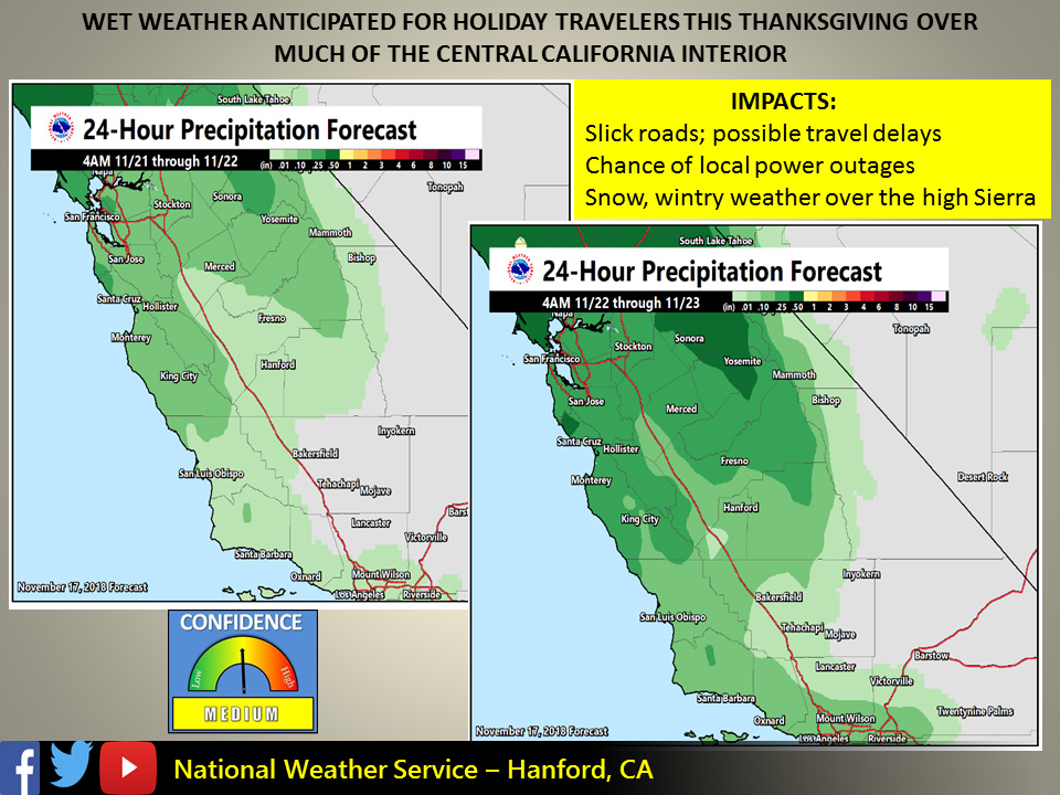
November 18, 2018 - The National Weather Service Hanford office reports a pattern change to wet weather is likely by the middle of next week.
Its arrival after a very long dry spell will create slick and potentially hazardous driving conditions on area roads and the possibility of local power outages.
Several inches of snow may fall over the higher elevations of the Sierra during the Thanksgiving Day holiday.
Hikers, campers and motorists should be prepared for much colder temperatures and wintry travel over the higher elevations of the Sierra this holiday weekend.
  Area Forecast Discussion
  National Weather Service San Joaquin Valley - Hanford CA
  345 AM PST Sun Nov 18 2018

  .SYNOPSIS...
  High pressure will continue over the region for the next few days
  providing above normal temperatures and dry weather. The high will
  finally weaken and allow low pressure from the Pacific to move into
  the area on Wednesday with cooler temperatures and wet weather.

  &&

  .DISCUSSION...
  Persistent upper ridge pattern remains in control over the region.
  The ridge axis has shifted a bit eastward to just along the west
  coast while an upper low is spinning offshore about 1000 miles
  west of Point Conception. Satellite imagery shows a band of high
  clouds stretching from NW-SE, covering much of Kern County while
  areas from Fresno County north have mainly clear skies. Surface
  observations continue to show reduced visibility in haze and smoke
  due to the wildfires. Unfortunately, this will be the case for a
  few more days as the ridge hangs on a bit longer. An Air Quality
  Alert remains in effect. Daytime temperatures will remain a few
  degrees above normal through Tuesday.

  Confidence continues to increase in a pattern change by Wednesday
  as the models converge on an upper trough bringing cooler weather
  and precipitation to the region. The upper low mentioned before
  will essentially open the door for this change as it shifts east
  over northern Baja as a weakening wave late Monday/early Tuesday.
  An amplified upper trough will approach the coast Tuesday night
  with increasing southwest flow aloft. Precipitation is expected to
  move in early Wednesday with the bulk of the event on Wednesday
  afternoon and night. Early estimates for rainfall amounts suggest
  one to three quarters of an inch in the San Joaquin Valley with
  the highest amounts favored for the east side of the valley and
  from Fresno County northward. Rain shadowing will limit amounts
  along the west side and in Kern County. QPF for the Sierra Nevada
  and adjacent foothills from Yosemite to Kings Canyon is 1" - 1.5".
  This will be of particular concern for Flash Flood and debris flow
  potential around the recent burn scars, such as the Ferguson Fire.
  Snow levels look to be around 6000-7000 feet with some significant
  accumulations possible over the high elevations. QPF amounts taper
  to the south with a quarter to one-half an inch for the Kern County
  mountains and one or two tenths of an inch in the desert.

  Latest model runs show there may be a lull in activity Thanksgiving
  day. Another trough is progged to dive down on Friday but takes a
  more inside slider track from the Pacific Northwest - Great Basin.
  This is a less favorable pattern for precip here in central CA as
  the flow aloft remains northwesterly, limiting orographic effects.
  So this second system for Friday into Saturday looks less impressive
  regarding QPF.

  In addition to the wet weather, a change to a cooler air mass will
  occur. Temperatures are forecast to lower to near normal Wednesday
  with clouds and precip then fall to below normal Thursday through
  the weekend. Winds will increase on Wednesday with breezy to windy
  conditions developing and continuing into the weekend. This change
  in air mass along with the winds will bring a welcome relief from
  the poor air quality. So most if not all should be very thankful
  later this week as we get both wet weather and cleaner air.
Source: NWS