
Update as of : 6:40 P.M.
4,689 Acres with 96% Containment
Basic Information
| Current as of | 8/3/2014 6:40:07 PM |
|---|---|
| Incident Type | Wildfire |
| Cause | Unknown |
| Date of Origin | Saturday July 26th, 2014 approx. 05:00 PM |
| Location | Communities of El Portal, Foresta in Yosemite Park, and Stanislaus National Forest |
| Incident Commander | Carlton Joseph |
Current Situation
| Total Personnel | 471 |
|---|---|
| Size | 4,689 Acres |
| Percent of Perimeter Contained | 96% |
| Percent of Perimeter To Be Contained | 4% |
| Estimated Containment Date | Saturday August 09th, 2014 approx. 12:00 AM |
| Fuels Involved | Chaparral (6 feet) brush, chaparral, grass, oak woodland at lower elevations. Timber (pine and cedar) at elevations above 4,500 feet. |
| Significant Events | Interior burning was the only fire activity today with creeping and smoldering. A spike camp was opened in Drew Meadows on the Stanislaus National forest. A significant demobilization of excess resources is in progress and most are being reassigned to other fires |
Outlook
| Planned Actions | No night shift will go out on the fire tonight. This is due to the status of the fire and concern for firefighter safety. There is the potential for thunderstorms with rain Making the firelines and road hazardous to travel on. |
|---|---|
| Projected Incident Activity | Burning on the interior of the fire line only. |
| Remarks | Fire Suppression Repair operations have been implemented. Of the total current acreage, 3597 acres are U.S. Forest Service DPA and 1092 acres are National Parks Service DPA. A Stanislaus N.F. Type 3 organization (El Portal) and a Yosemite National Park Type 3 organization (Dark Hole) will begin shadowing CIIMT 5 tomorrow for a Transfer of Command on Tuesday 8/5. |
Current Weather
| Weather Concerns | The incident did not receive direct sun today due to the approach of monsoonal moisture from the south that may produce thunderstorms and rain overnight. |
|---|
Update: 6:15 P.M.
El Portal Fire MODIS Fire Activity 1800 MDT Aug 3 2014.
The red boundary is the fire perimeter for Aug 2 2014 at 2231 hours PDT.
This map shows MODIS fire activity for the El Portal Fire in Yosemite National Park. The green line is the park boundary.
The red boundary is the fire perimeter as of Aug 2 2014 at 2231 hours PDT.
There are NO recent MODIS fire activity footprints (indicated by red footprints).
The map shows the location of the Giant Sequoia groves and the Crane Flat campground. (note by Joe Coho)
Thanks to Joe Coho for assembling all the maps during this fire.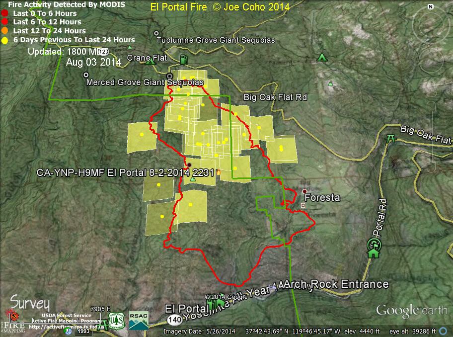
Update: 7:30 A.M.
4,689 Acres and 89% Containment
Basic Information
| Current as of | 8/3/2014 7:02:24 AM |
|---|---|
| Incident Type | Wildfire |
| Cause | Unknown |
| Date of Origin | Saturday July 26th, 2014 approx. 05:00 PM |
| Location | Communities of El Portal, Foresta in Yosemite Park, and Stanislaus National Forest |
| Incident Commander | Carlton Joesph |
Current Situation
| Total Personnel | 632 |
|---|---|
| Size | 4,689 Acres |
| Percent of Perimeter Contained | 89% |
| Percent of Perimeter To Be Contained | 11% |
| Estimated Containment Date | Saturday August 09th, 2014 approx. 12:00 AM |
| Fuels Involved | Chaparral (6 feet) brush, chaparral, grass, oak woodland at lower elevations. Timber (pine and cedar) at elevations above 4,500 feet. |
| Significant Events | Interior burning was the only fire activity tonight with creeping and smoldering. A spike camp was opened in Drew Meadows. A significant demobilization of excess resources is in progress. |
Outlook
| Planned Actions | Patrol and continue to mop up completed firing operation on the north, east and west sides of the fire. Crews will be implementing Fire Suppression Repair Guidelines on dozer and hand lines throughout the perimeter. |
|---|---|
| Projected Incident Activity | Burning on the interior of the fire line only. |
| Remarks | Excess resources are being released. Of the total current acreage 3,597 acres are U.S. Forest Service DPA and 1,092 acres are in National Park Services DPA. |
Current Weather
| Weather Concerns | Weather conditions in the fire area will become hotter and drier. |
|---|
Map showing dozer lines and firebreak lines
'Click' here to view larger map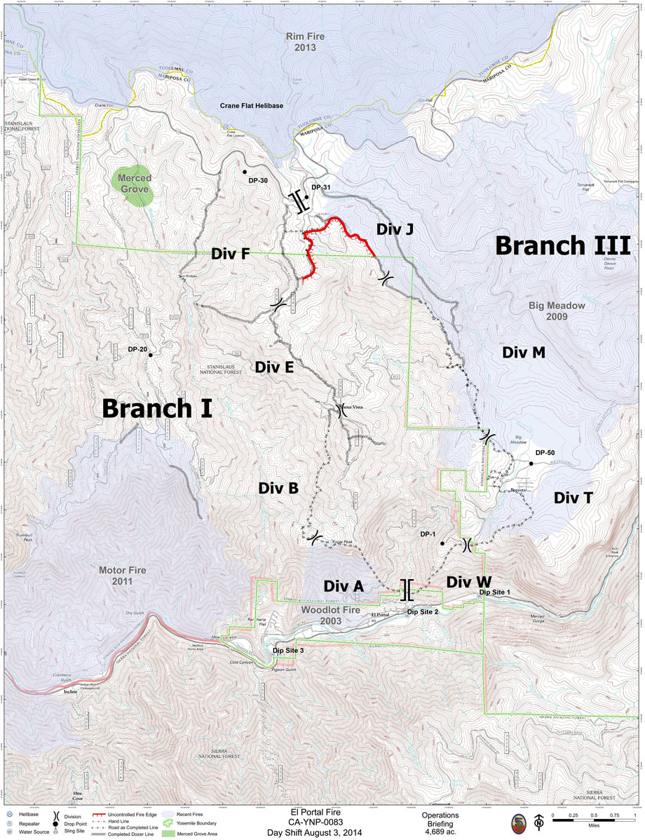
Update for 8/2/14 7:35 P.M.
Incident Overview
Firefighting efforts on the El Portal Fire continue to go well. Crews are strengthening the containment line and aggressively cooling hot spots near the fire’s perimeter. Please see tonight's 8:00 p.m. update for more information on the fire. Starting tomorrow, there will be just one daily update issued at 8:00 a.m.
Due to reduced call volume, the El Portal Fire Information Call Center will be open from 8:00 to 4:00.
Basic Information
| Current as of | 8/2/2014 7:33:54 PM |
|---|---|
| Incident Type | Wildfire |
| Cause | Unknown |
| Date of Origin | Saturday July 26th, 2014 approx. 05:00 PM |
| Location | Communities of El Portal, Foresta in Yosemite Park, and Stanislaus National Forest |
| Incident Commander | Carlton Joesph |
Current Situation
| Total Personnel | 1,056 |
|---|---|
| Size | 4,689 Acres |
| Percent of Perimeter Contained | 89% |
| Percent of Perimeter To Be Contained | 11% |
| Estimated Containment Date | Saturday August 09th, 2014 approx. 12:00 AM |
| Fuels Involved | Chaparral (6 feet) brush, chaparral, grass, oak woodland at lower elevations. Timber (pine and cedar) at elevations above 4,500 feet. |
| Significant Events | Continue holding and mop up of completed firing operation |
Outlook
| Planned Actions | Patrol and continue to mop up completed firing operation on the north, east and west sides of the fire. Crews will be implementing Fire Suppression Repair Guidelines on dozer and hand lines throughout the perimeter. |
|---|---|
| Projected Incident Activity | Burning on the interior of the fire line only. |
| Remarks | Excess resources are being released. Of the total current acreage 3,597 acres are U.S. Forest Service DPA and 1,092 acres are in National Park Services DPA. |
Current Weather
| Weather Concerns | Weather conditions in the fire area will become hotter and drier. |
|---|