
French Fire in Madera County Information for Sunday, August 3, 2014
Click here for Information from Saturday, August 2, 2014
Update as of : 6:50 P.M.
12,827 Acres with 30% Containment
Basic Information
| Current as of | 8/3/2014 6:49:54 PM |
|---|---|
| Incident Type | Wildfire |
| Cause | Human |
| Date of Origin | Monday July 28th, 2014 approx. 05:45 AM |
| Location | Mammoth Pool |
| Incident Commander | Dave Cooper |
Current Situation
| Total Personnel | 1,813 |
|---|---|
| Size | 12,827 Acres |
| Percent of Perimeter Contained | 30% |
| Fuels Involved | Timber with some brushy areas |
| Significant Events | Division X was at the most active flank of the fire today with perimeter growth along the western flank towards Shuteye Pass. In Division Z perimeter has extended to the western shore of Mammoth Pool, and is continuing to spread towards Mammoth Pool Dam. To the north and northeast the fire's spread has been checked with direct lie being constructed from Chiquito Creek towards 4S81. In the southeast in Division B, the completed fire operations continues to back to the San Joaquin River. A forest road closure is in effect. This closure is for the section of 4S81 between Redinger Overlook, the Grizzly Road between 5S07 and Road 4S81 and Road 7S07 off of the 8S09 Road. Power has been shut off to the Mammoth Pool area. A total of 12 campgrounds have been evacuated. Residences in the Arnold Meadows and tract have been evacuated. Kinsman Flat home tract are threatened. Cultural and natural resources are threatened. |
Outlook
| Planned Actions | Structure protection in the Hogue Ranch, Kinsman Flat and Arnold Meadows will continue to be the primary objective. |
|---|---|
| Projected Incident Activity | 12 hr: Perimeter will continue to grow in Divisions X with active fire. Division Z on the east side of the fire will continue backing to the San Joaquin. Fire will continue to back in Division B as backing fire from firing operation proceeds to the San Joaquin. 24 hr: Due to instability of the atmosphere in front of incoming monsoonal moisture, high winds and increasing fire behavior is expected. Thunderstorm activity is expected. These factors, combined with the shortage of critical resources, could lead to significant fire grown and increased resource threat. |
| Remarks | Completed firing operations into the San Joaquin River in Division B continue to consume fuels. Object is to secure the bottom perimeter of the fire in Division B and E. This burnout operation was to provide for the defense of structures at the Hogue Ranch and in the Kinsman Flat area. Another firing operation to secure the area surrounding Wagners Store was completed along Chiquito Creek. Direct fire line was completed from Chiquito Creek to the 4S81 Road on the north end of the fire. The fire has been backing on the east flank towards the San Joaquin River and continued to burn and fill in control objectives. Fire activity to the west in Division X was active, advancing toward Shuteye Pass. This movement is expected to increase as the fire moves into denser fuels. Crews and dozers continued heading north of the 7S07 Road into Division K. Incident priority is to check the spread to the north near the Mammoth Pool Reservoir. The fires northwesterly spread is still a concern. The established incident objectives are heavily dependent on Type 1 Hand Crews, Rotor-wing Aircraft, Fixed-wing Aircraft, Dozers and Type 3 Engines. |
Current Weather
| Weather Concerns | Cloudy with much cooler temperatures today of around 80. As a result, winds were fairly light with RH that remained in the 30s all day. Predicted: Cloudy with potential showers/thunderstorms and less smoke as the upper low moves over the area tonight. Winds will be generally light except for erratic winds near any thunderstorms. |
|---|
Update: 7:34 A.M.
12,877 acres, 20% Contained.
Fire activity continued through the night with ground fire and some torching.
Residences in the Arnold Meadows and Kinsman Flat home tract remain evacuated.
Structure protection will remains in place in the Hogue Ranch, Kinsman Flat and Arnold Meadows area.
An investigation has concluded, that an abandoned campfire near the Rock Creek Campground was the cause of the French Fire...
Read more below map.
Map of the French Fire for Sunday, August 3, 2014
'Click' here to view larger map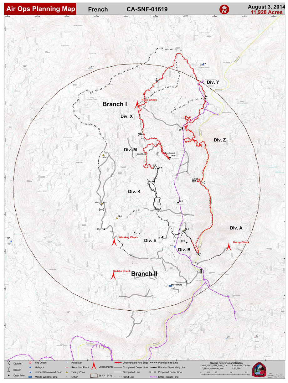
Update for 8/2/14 7:40 P.M.
Incident Overview
An update on acreage will be released in the morning fire update after a mapping flight is conducted tonight.
Cause of the French Fire Released, Public’s Help Needed.
An investigation has concluded, that an abandoned campfire near the Rock Creek Campground was the cause of the French Fire on the Bass Lake Ranger District of the Sierra National Forest. The abandoned campfire was located towards the bottom of Rock Creek Road, near the San Joaquin River, as shown in the map below. Investigators believe a long log was left in the campfire, extending into nearby pine needles. As the log burned and reached the pine needles, the fire extended into the forest starting the French Fire.
For just this reason, a Forest Order has been in place since June 25, 2014 restricting campfires in the Sierra National Forest, to help prevent just such an incident given the extreme drought conditions existing on the Forest. Campfires were not permitted unless they were in a designated campground during the time of the incident. “It is an unfortunate and unnecessary loss for all of us, that due to the irresponsible actions of a few, a portion of a national treasure has been lost, not to mention putting lives and homes at risk” said Dean Gould, Forest Supervisor, Sierra National Forest. To date, close to 12,000 acres have burned, at an incident response cost of 8 million dollars to date, which does not include the value of resources or property lost or damaged.
Investigators with the Sierra National Forest are asking for the public’s help for information about anyone who was seen in the area of Rock Creek Road near the San Joaquin River on during the afternoon or evening of Sunday July 27.
Anyone with information is encouraged to call the French Fire Information line at 559-877-2605.
Basic Information
| Current as of | 8/2/2014 7:35:35 PM |
|---|---|
| Incident Type | Wildfire |
| Cause | Abandon Campfire |
| Date of Origin | Monday July 28th, 2014 approx. 05:45 AM |
| Location | Mammoth Pool |
| Incident Commander | Dave Cooper |
Current Situation
| Total Personnel | 1,763 |
|---|---|
| Size | 11,466 Acres |
| Percent of Perimeter Contained | 15% |
| Fuels Involved | Timber with some brushy areas |
| Significant Events | The north and northeastern parts of the fire continue to be areas with largest growth. The northeastern perimeter has extended to the western shore of Mammoth Pool, just north of the boat ramp. |
Outlook
| Planned Actions | Structure defense in the Hogue Ranch, Kinsman Flat, and Arnold Meadows area will continue to be the primary objective. |
|---|---|
| Projected Incident Activity | Perimeter will continue to grow on the north and west sides of the fire. |
| Remarks | The firing operations in the San Joaquin River are scheduled for completion tonight. Another firing operation is planned for the area around Wagners Mammoth Pool Resort. |
Current Weather
| Weather Concerns | Increasing clouds overnight with smoke settling in the canyon. |
|---|