
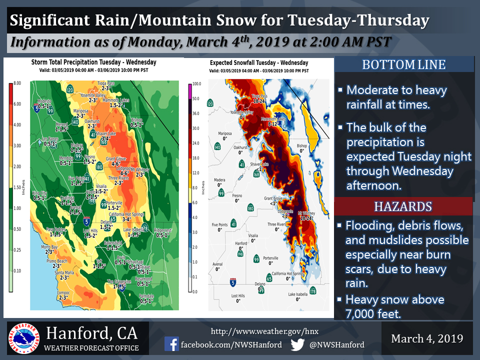
Projected rainfall totals for Mariposa: 2.00" to 3.00"
Projected rainfall totals for Oakhurst: 2.00" to 3.00"
Projected rainfall totals for Yosemite Valley: 2.00" to 3.00"
March 4, 2019 - The National Weather Service Hanford Office reports an atmospheric river is expected to bring significant rain and high elevation snow to much of the Central California interior during Tuesday through Thursday.
  Area Forecast Discussion
  National Weather Service San Joaquin Valley - Hanford CA
  258 AM PST Mon Mar 4 2019

  .SYNOPSIS...High pressure will move over the region on today for
  a brief period of dry weather. However, a moisture laden weather
  system will arrive on Tuesday and persist until Thursday. Another
  system will bring unsettled conditions Thursday night into at
  least Friday.


  &&

  .DISCUSSION...Mostly cloudy skies persist during the overnight
  hours, although cloud cover is expected to partially clear for
  today, as a weak upper-level ridge of high pressure moves over
  Central California. At this time, a few showers remain in the
  Sierra Nevada foothills towards Mariposa and Oakhurst, but are
  expected to weaken by daybreak. The remainder of today into
  tonight will likely be the only dry period for the next several
  days, as the weak ridge quickly exits our forecast area.

  Clouds will once again increase by late tonight and Tuesday
  morning as subtropical moisture begins to stream in the mid and
  upper levels. Additional moisture, or the atmospheric river plume,
  will into our area from the southwest by Tuesday afternoon to
  begin producing rain over much of the region, and the heavier
  precipitation will begin in earnest by Tuesday night. As the
  subtropical airmass will be fairly warm, snow levels will rise
  above 8,000 feet during Tuesday and Tuesday night before falling
  back to around 7,000 feet by Wednesday with the arrival of the
  cold front that will push the moisture plume over Southern
  California. Rain amounts from Tuesday afternoon into Wednesday
  will be quite impressive. Around one to two inches of rain is
  expected in the San Joaquin Valley, with 2 to 3 inches in the
  Sierra Nevada foothills and Kern County Mountains. In addition,
  rain amounts could reach as high as 3 to 5 inches in the Sierra
  Nevada below the snow line. Flooding, mudslides, and debris flows
  remain a concern, with the greatest threat near the recent burn
  scars. It appears the greatest amounts of precipitation will occur
  over the Sierra from around Kings Canyon and into much of Tulare
  County, as models have been consistently advertising for the last
  few days. Snow amounts in the Sierra Nevada, though at very high
  elevations, will range from 1 to 2 feet in most locations, but
  quite a few locations could receive around 3 feet. During Tuesday
  night into Wednesday, the bulk of the precipitation is expected,
  although a secondary concern during this time could be gusty winds
  along the west side of the San Joaquin Valley and through the
  Kern County mountain areas towards the Grapevine, as south-
  southwesterly flow moves over our region. Also, expect isolated
  thunderstorms for Wednesday afternoon and evening, as the
  atmosphere becomes unstable behind the cold front. During
  Wednesday evening and into Thursday, snow levels will continue to
  lower a little, and at least showery precipitation will likely
  continue until Thursday, as upper-level impulses will pass over
  our region.

  Another low pressure trough will arrive by Thursday night and is
  expected to be relatively cold. Snow levels could lower to around
  3,000-3,500 feet in the Sierra Nevada foothills and around 4,000
  feet by Friday morning in Kern County. Snow is a possibility at
  the pass levels in the Tehachapi Mountains. Forecast precipitation
  amounts will be relatively light with this next system, due to
  limited moisture. Showers will linger into Friday behind the
  trough.

  A brief break in the precipitation is in store for Saturday with
  another weak ridge of high pressure, but another weather system
  is forecast to arrive by Sunday. Models are in agreement that
  another decent subtropical moisture plume will set up, but
  placement of this feature varies greatly. It appears this system
  will pass mainly to our south, but could at least bring some
  showers to our southern forecast area, such as south of Fresno
  County. So, unsettled conditions are possible once again for early
  next week.
Source: NWS