
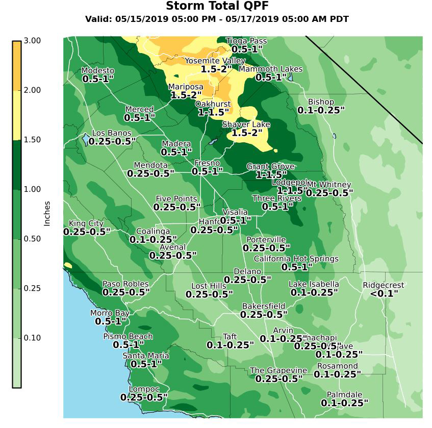
Projected rainfall totals for Mariposa: 1.50" to 2.00"
Projected rainfall totals for Oakhurst: 1.00" to 1.50"
Projected rainfall totals for Yosemite Valley: 1.50" to 2.00"
May 15, 2019 - The National Weather Service Hanford Office reports a storm system will impact Central California Wednesday night into early Friday morning.
Heavy snow is likely in the Southern Sierra Nevada above 7,000 feet, where a Winter Storm Warning is in effect.
Most of this precipitation will fall Wednesday night & Thursday morning.
  Area Forecast Discussion
  National Weather Service San Joaquin Valley - Hanford CA
  225 AM PDT Wed May 15 2019

  .SYNOPSIS...
  A disturbance will impact the forecast area starting tonight
  through Friday morning brining valley rain and mountain snow. A
  series of storm systems arriving on Saturday night and continuing
  through Tuesday will bring unsettled wet weather to the region.

  &&

  .DISCUSSION...
  Today, there will be a sharp fall in high temperatures today due
  significant cloud cover associated with the upcoming
  trough/atmospheric river event coming tonight, leading to highs
  5-9 degrees cooler than yesterday. By mid afternoon today, a few
  upsloping showers will be possible in the Sierra Nevada north of
  Tulare County, with increasing coverage towards the evening. A few
  showers may also be possible in the valley this evening as
  difluent pattern aloft occurs over the district. By tonight, high
  resolution model guidance is showing the cold frontal band/heavy
  rain passing through the CWA between 06z and 15z depending on
  location. Locally gusty winds in the western portion of the valley
  will precede the frontal passage as well. Rainfall totals near
  1/2" to 3/4" may occur through tomorrow morning in the northern
  portion of the SJ Valley and totals up to 1/3" in the southern
  portion of the valley. In terms of mountain snow, snow levels will
  begin around 8500 feet in the Southern Sierra tonight, and will
  fall to around 5000-5500 feet by late Thursday morning. See our
  Winter Storm Warning for more details on the Sierra Nevada snow.

  Post frontal convective activity also would seem conceivable
  tomorrow afternoon in the SJ Valley, especially if there are
  breaks in the clouds by late morning. Thunderstorms that may occur
  under the cold pooling aloft could be capable of small hail,
  gusty winds, locally heavy rain, and perhaps even a funnel cloud
  or two -- much like the thunderstorms we saw earlier this year
  Jan through March. Lingering moisture from today`s/tomorrow`s
  storm may induce light precipitation Friday as a weak impulse
  grazes the forecast area. Late Friday night/Saturday morning, ECM
  and GFS are showing shortwave ridging occuring over Central
  California, which may provide a brief break from the active
  weather. However, this ridge will quickly be broken down as
  another storm approaches the CWA from the northwest. Additional
  valley rain and mountain snow are progged to occur with this
  system through Sunday, but details on accumulations are not clear
  yet.

  By Monday, there could be another break from the precipitation in
  Central California before another storm on Tuesday, however the
  specific details of this third storm are not clear this far out.
  Thereafter, EPS progs show the Pacific Jet staying active/very
  strong through the foreseeable future, which likely corresponds
  with the CPC`s Day 6-10 and 8-14 Precipitation Outlook, which both
  have California at above-normal precip chances compared to May
  climatology favored.
Source: NWS