
California and National Drought Summary for August 20, 2019
Summary
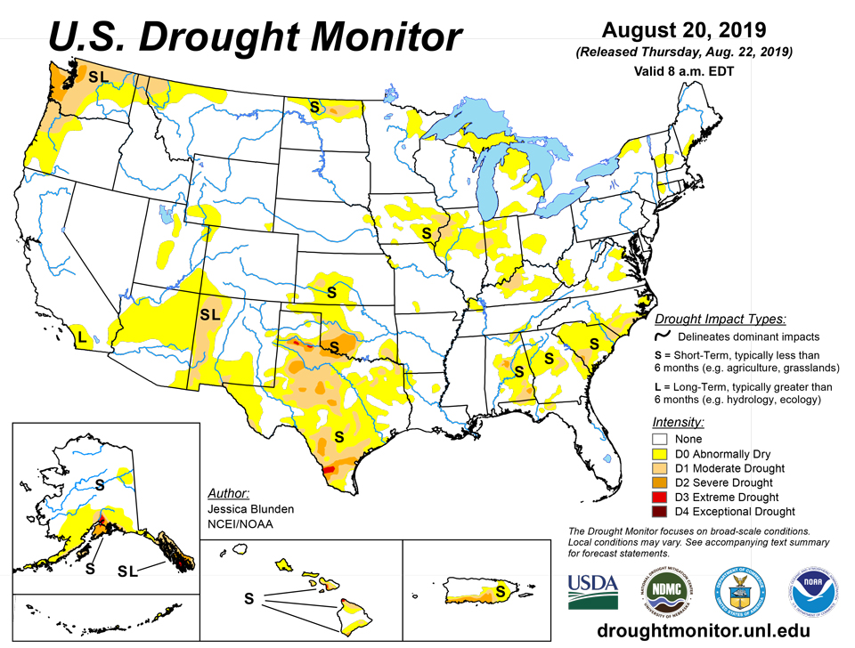
August 22, 2019 - The United States is in the thralls of summer, and with that can come heat, flash droughts, and occasional, if not frequent, thunderstorm activity. Several areas of the U.S. experienced extreme heat this past week, particularly notable across much of the South and in the East. Parts of western Texas and eastern New Mexico were 6-10 degrees F above their typical averages, with little rainfall to speak of in much of the region. On the other hand much of the northern tier of the U.S. into the Upper Midwest was cool for this time of year, although precipitation amounts there were a mixed bag. In the Southwest, the North American monsoon continues to fail, worsening conditions in areas that had received more than ample precipitation over the winter and spring. To the north, south central Alaska continues to see record or near-record heat and dryness, and conditions are deteriorating quickly there, with severe impacts.
Northeast
There was an expansion of abnormally dry conditions (D0) in southwestern West Virginia. This area has received very little rain over the past couple of weeks, combined with above-average temperatures since the start of summer. In New England, there was some much needed precipitation over the abnormally dry areas there. This prevented the need for deterioration, but was insufficient to erase the longer-term deficits. There were reports of brown fields and rolled soybeans in New York's Monroe and Orleans over the past week, but rainfall there over the weekend seemed to be sufficient for the time being. This is an area to watch.
Southeast
Northern Virginia received adequate rainfall over the past week and a large part of the abnormally dry (D0) conditions that appeared the previous week have disappeared again. Despite near-record heat at Dulles International Airport, green up has been substantial. Southwestern Virginia, on the other hand, did not receive widespread precipitation, but rather bursts from thunderstorm activity. Above-normal temperatures have contributed to parched topsoil in places and D0 expanded to the south and to the north near Roanoke. Coastal North Carolina received heavy rain that totaled 5 or more inches in many areas, including Wilmington and New Bern, substantially lowering three-month deficits. As a result, streamflow conditions have improved and recently planted crops such as soybeans are doing well. As such, much of the immediate coast improved one drought category, to D0 or back to normal conditions. In South Carolina, Charleston and Myrtle Beach reported over 4 inches of rain for the week. On the other hand, some counties in the Low Country near the Georgia border reported less than 0.25 inch over the same period, accompanied by extreme heat, with areas reaching temperatures of 100 degrees F or higher. With reports of crop stress, reduced pasture forage and yield, and increased irrigation, severe drought (D2) was introduced and moderate drought was expanded. Abnormally dry conditions were expanded in surrounding counties in the west. D0 also expanded in west central Georgia, but conditions improved farther to the south in the state, with moderate drought (D1) substantially declining. In Alabama, Huntsville reached 100 degrees F on August 19th for the first time since July 2016 and precipitation was lacking in many areas, with the exceptions of southern Alabama and the far northwest. D0 and D1 were expanded in the eastern half of the state. Severe drought was expanded in the central part, but removed by the Florida border.
South
Aside from isolated and scattered rains, most of the area was very hot and dry, with daytime temperatures climbing to near or above 100 degrees F over portions of the region. Nighttime temperatures did not help alleviate the heat stress in places. Along the northern Gulf Coast, Galveston, Texas -- which had never observed a minimum temperature above 85°F since its records began in 1874 -- has recorded three to date this month: on August 8th, 12th, and again on the 18th. Overall, there was some drought relief in a few spots in the South, but mostly there was drought expansion across the area where changes were made this week. There is a flash drought in north central and northeast Texas, with some stations that are 10 inches above normal for the year, but 8 inches below normal for just the past two months. In eastern Texas, abnormally dry conditions (D0) were expanded across much of the area. Reported rainfall in areas was only 20 percent of normal. The D0 in far east Texas expanded eastward into extreme southwestern Arkansas where there have been reports of a sharp drop off in the green up along the interstate across southern Miller County, with some exposed areas browning quickly, and in northwestern Louisiana where reported precipitation at some stations has been just 50-70% of normal over the past two months. In Oklahoma, much of the southwest has seen less than 25% of its normal precipitation over the past two months, and less than 50% over the past three. Severe and moderate drought were expanded here and a couple of pockets of extreme drought (D3) were introduced to the west in the Texas Panhandle. In southeastern Tennessee near Chattanooga, abnormally dry conditions and moderate drought (D1) were each extended farther to the northeast. Over the past month there have been several periods of high temperatures leading to stress on vegetation and livestock.
Midwest
Heat and a lack of substantial rain in many areas contributed to expansion of abnormally dry (D0) conditions across parts of the Midwest, including northern Michigan into the Upper Peninsula, west central Ohio, eastern Indiana, and Kentucky. An area of moderate drought (D1) was also introduced in central Kentucky, with reports that late planted corn, soybeans, and pastures are affected and that some farm ponds are beginning to get low, especially in Hardin, LaRue, and Breckinridge Counties. Ohio reports indicate that crop stress and brown lawns are now evident. In Iowa, the rainfall had a relatively strong gradient, as conditions improved across parts of southern Iowa, although D1 did expand a bit in the southeastern corner.
High Plains
Eastern Nebraska was fairly dry over the past week where the D0 is present. With little rainfall over the past month and a half, the D0 area was extended slightly north into Thurston and eastern Wayne counties. To the north, some beneficial rains fell across North Dakota over the last week; however, considering local crop impact reports, only the D0 area in the west central region was improved to normal. Unfortunately, the rains were not adequate enough for improvement across the northern tier of the state.
West
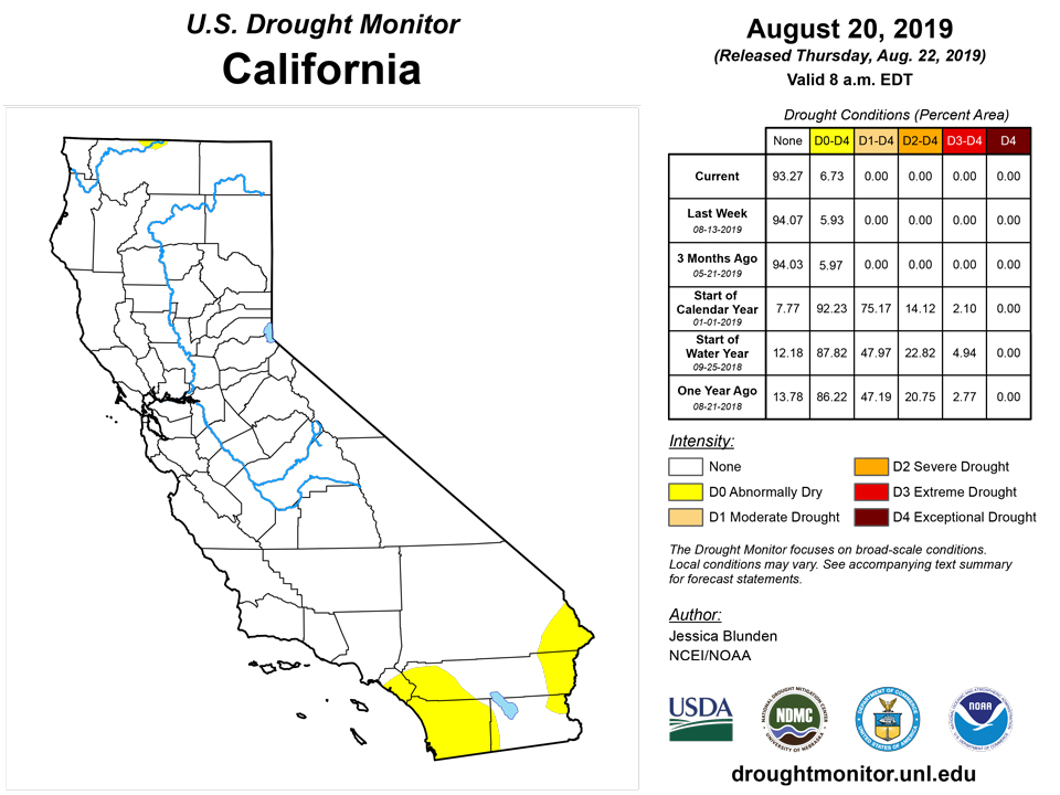
Far into the monsoon season, the rains continue to fail in the Southwest. Only the abundant precipitation that fell last winter is keeping substantial impacts at bay so far this summer. Even so, declining topsoil moisture and poor rangeland conditions through Mohave County, Arizona, are now being reported. Abnormally dry conditions (D0) were expanded nearby in central and north central Arizona through all of Yavapai County and most of Coconino County. It was also expanded southwestward into Riverside and Imperial Counties in California. Moderate drought (D1) was extended farther south in western New Mexico, and a small area was introduced to the south central part of the state at the Texas border. Abnormally dry conditions and moderate drought also crept into the far southeastern corner this week.
Alaska, Hawaii, and Puerto Rico
While heavy rain fell in the interior over the Yukon Flats, alleviating a region of abnormal dryness there, conditions in south central Alaska deteriorated as record and near-record heat and dryness continued. The Anchorage Airport has received only 0.84 inches of rain since June 1st and is on track to record its driest June-August on record. For August to date, little to no precipitation has fallen in what is typically the peak of the wet season. Extreme drought (D3) was introduced to this area, extending north toward Talkeetna and south to the top of the Kanai Peninsula. Severe drought (D2) was extended south across most of the remainder of the Peninsula. The lack of precipitation along with the persistent warmth has led to unprecedented dry conditions and very high to extreme fire danger. Smoke from multiple wildfires is prevalent across portions of the Kenai Peninsula, Anchorage Bowl, and Mat-Su Valleys, reducing visibility to less than one mile near active fires. Widespread areas of deciduous trees and bushes are turning brown and dropping leaves now, which is unprecedented, exacerbating the fire danger. Kodiak is now in voluntary water restrictions, receiving only 33% of its normal precipitation since June 1st. Moderate drought (D1) has been introduced across the island. On the Alaskan Peninsula, new fires have been reported, and the community of Chignik is reporting severe water issues and a water emergency. Abnormal dryness (D0) and some D1 was introduced across the region and will continue to be monitored closely.
Hawaii has generally been dry recently, with the exception of the western and interior sections of the Big Island. An anomalous shift in the direction of the trade winds has also affected trade wind rainfall over the Hamakua and windward Kohala portions of the Big Island. These areas have been unusually dry for this time of the year. Ranchers near Paauilo and Ookala in the Hamakua District have been hauling water for their livestock. Severe drought (D2) was introduced to this area. Conditions worsened across the island of Lanai and D2 was introduced in the southwest.
Pacific Islands
The weather pattern during this USDM week (8/14/19-8/20/19) consisted of a series of weak circulations, and the development of a monsoon trough, from the Marianas eastward across the northern Federated States of Micronesia (FSM) to the Marshall Islands (RMI). Divergence associated with an upper-level trough east of the Marianas enhanced rainfall over northern parts of the FSM. A surface high dominated the weather over southwest Micronesia until the building monsoon trough displaced it with converging monsoonal winds. South of the equator, a ridge dominated the weather over the Samoan Islands at the beginning of the week, until a trough moved from the north to the south across the islands.
Satellite-based estimates of 7-day precipitation (QPE) showed a band of 2+ inches of rain stretching across Micronesia, from the Marianas and northern Yap State to the Marshall Islands, with embedded areas of 4+ inches of rain. Rainfall amounts tapered off to below an inch north and south of the band. This band was part of the monsoon trough which stretched northwest to Asia. The QPE showed areas of 1+ inches of rain over and around the Samoan Islands, with an area of 2+ inches brushing Tutuila.
Southern parts of the Republic of Palau were dry, but northern parts were wet (more than the 2-inch weekly minimum required to meet most water needs) with the Palau International Airport reporting 3.52 inches of rain this week. D-Nothing continued at Palau.
The monsoon trough also spread abundant rainfall across the Marianas. Weekly rainfall totals ranged from 2.10 inches at Guam and 2.71 inches at Saipan to 3.62 inches at Rota. D-Nothing continued in the Marianas.
In the FSM, the week was wet along the path of the monsoon trough, with rainfall amounts ranging from 2.42 inches at Kapingamarangi and 2.84 inches at Lukonor to 5.57 inches at Chuuk and 6.36 inches at Fananu. Amounts were less than the 2-inch weekly minimum south and west of the trough, with Yap reporting 1.25 inches and Nukuoro 1.66 inches. With this week wet, or the month (so far) wet, D-Nothing continued at all FSM stations except Ulithi which was not analyzed due to missing data. The last 3 weeks have each been dry at Yap, but rain fell on most days this week, so D-Nothing continued this week. However, D0-S may be considered for Yap if less than 2 inches of rain is recorded next week.
In the RMI, 3 stations were wet this week: Ailinglapalap (with 3.02 inches), Jaluit (3.07), and Utirik (2.61). Utirik has been wet the last 3 weeks, has gotten rain on 14 of the 18 days through August 18th, and the August total rainfall through the 18th is 7.07 inches; compared to full Augusts, this ranks as the 8th wettest August out of 16 years of data, and the month isn’t even over yet. As a result, Utirik was improved from D2-SL to D1-L. Jaluit’s 3.07 inches of rain breaks a long run of dry weeks. August 2019 has had 4.84 inches of rain through the 20th; this compares to full Augusts as the second driest August on record. The previous months have been dry, with April-July 2019 ranking as the driest April-July in 35 years of data, so Jaluit stayed at D2-SL. Majuro was dry this week with 1.24 inches of rain. The August 19th reservoir level at Majuro was 28.563 million gallons, which is 79% of maximum, just below the 80% threshold for concern, so D0-S continued at Majuro. The rest of the RMI stations were dry this week, so their status remained unchanged from last week.
It was a wet week in American Samoa. The airport station at Pago Pago reported 6.16 inches of rain, and the automated stations at Siufaga Ridge and Toa Ridge recorded 3.90 inches and 3.13 inches, respectively, so D-Nothing continued for Tutuila.
Virgin Islands
During this USDM week (8/14/19-8/20/19), the U.S. Virgin Islands (USVI) experienced a series of weather systems that brought dry weather then wet weather. The week began with the North Atlantic High (Bermuda High) sending easterly trade winds across the islands with embedded dry dusty Saharan air. TUTT (Tropical Upper-Tropospheric Trough) lows to the northeast sent a weak upper-level trough over the islands, and this was followed by a tropical wave. Radar-based estimates of rainfall for the 7 days ending at 12z on Tuesday depicted half an inch or more over St. John, a tenth to a half inch over parts of St. Thomas, and little to no rain over most of St. Croix.
On St. Croix, the Henry Rohlsen AP station reported 0.06 inch of rain this week. The monthly total is 1.85 inches, which is slightly below normal. The year-to-date is 14.60 inches, which is 4.30 inches below normal. The Standardized Precipitation Index (SPI) is wet for the last 1 to 3 months, but at D1 levels at the 9- and 12-month time scales. The CoCoRaHS observer at Christiansted reported 0.26 inch of rain so far this week and only 1.13 inches for the month to date. The USGS Adventure 28 Well station is showing a steady decline in groundwater levels since June to the lowest levels in the last year. The USDM status for St. Croix was worsened to D1-L to reflect the SPI and groundwater conditions.
On St. Thomas, the Cyril E King AP station reported 0.24 inch of rain this week. The monthly total is 1.88 inches, which is 0.34 inch below normal. The year-to-date is 18.57 inches, which is slightly below normal. The SPI is wet at 1-6 months, and at D0 levels for the last 12 months. The CoCoRaHS observer at Anna’s Retreat reported 0.10 inch of rain for the week and 2.34 inches for the month to date. The USGS Grade School 3 Well had a spike in groundwater levels a few weeks ago, but has declined sharply in the last couple weeks. St. Thomas remained at D0-L.
On St. John, half an inch (0.54) of rain was reported by the volunteer observer at Windswept Beach. This brings the monthly total to 2.52 inches, which is below the long-term average, and the yearly total to 18.02 inches, which is 77% of the long-term average. The USGS Susannaberg DPW 3 Well shows groundwater levels that have remained fairly consistently at the lowest levels in the last 12 months. As a result, D0-L continued on St. John.
Looking Ahead
Over the week beginning Tuesday, August 20, according to NOAA’s Climate Prediction Center, dry conditions are expected to continue across much of the western half of the continental U.S. Some heavy rain may fall over parts of the Midwest and Southeast, with as much as five inches in areas of southern Iowa, northern Mississippi, eastern Nebraska, and parts of the Carolinas. Southern Louisiana may see up to seven inches. Looking further ahead to August 25-29, below-normal temperatures are favored across parts of eastern Montana, the Dakotas, Nebraska, Kansas, Minnesota, Iowa, and Missouri, while above-normal temperatures are forecast for parts of the Southern Plains and the Southwest. There are enhanced probabilities of above-normal temperatures for most southern coastal locations of Alaska due to above-normal sea surface temperatures. Near to below-normal precipitation is possible for the west, although parts of Southern California may see above-average rainfall. Rainfall may be above normal across the central and eastern U.S., except for parts of the Northeast. Above-normal precipitation is favored across northern and eastern Alaska, but may be below-normal across southwestern mainland Alaska and the Aleutians, where drought conditions prevail. Please note the forecast confidence for this period is average, according to CPC.
Author(s):
Jessica Blunden, NOAA/NCEI
Richard Heim, NOAA/NCEI
Dryness Categories
D0 Abnormally Dry—used for areas showing dryness but not yet in drought, or for areas recovering from drought.
Drought Intensity Categories
D1 Moderate Drought
D2 Severe Drought
D3 Extreme Drought
D4 Exceptional Drought
Drought or Dryness Types
S Short-Term, typically less than 6 months (e.g. agricultural, grasslands)
L Long-Term, typically greater than 6 months (e.g. hydrologic, ecologic)
Source: National Drought Mitigation Center