
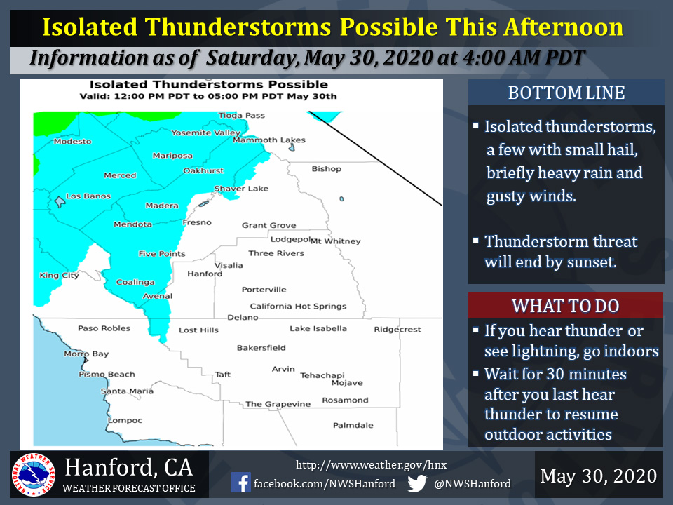
Mariposa County Including Yosemite National Park and Madera County Including Oakhurst
May 30, 2020 - The National Weather Service Hanford Office reports isolated thunderstorms are possible in the blue shaded area until about sunset early this evening.A few storms will bring briefly heavy rain, small hail, gusty winds and lightning.
When thunder roars, seek shelter indoors!
  Area Forecast Discussion
  National Weather Service Hanford CA
  208 AM PDT Sat May 30 2020

  .SYNOPSIS...
  Low pressure will move northward along the coast today bringing
  a threat of showers and a thunderstorm or two to parts of
  the area. The low will move to the north of the region tonight
  with another area of low pressure developing next week for
  continued cool and potentially unsettled weather.

  &&

  .DISCUSSION...
  Quite a dynamic weather pattern this morning over the forecast
  area as unseasonably deep low pressure spins off the Central
  California coast as it tracks to the north. Lots of different
  cloud bands noted on satellite imagery with radar showing
  a developing band of showers from the coast range to Monterey
  Bay as of 200 AM. Winds continue to be rather strong and gusty
  along the coastal ranges with speeds locally still exceeding 45
  mph. The wind advisory remains in place through 400 AM for this
  area.

  With the center of the big low moving north to northeast towards
  the Bay Area this morning, expect an increase in shower activity
  and with the strong dynamics, thunderstorms cannot be ruled out.
  Short range models including the HRRR and NAM12 show the best
  instability and convective threat will be limited to Merced and
  Western Fresno Counties as well as the Sierra generally north of
  Kings Canyon. Areas of the south and east of this will stay dry
  but will be markedly cooler. Speaking of cooler, the big change
  out of airmass is completed and for today the highs will range
  from the mid to upper 70s in Merced County with widespread lower
  80s replacing the 102-107 highs of just two days ago.

  Due to the low heights from the low pressure system, enough cooler
  air is in place for some snow above 9000 feet in the Sierra today
  in mainly the Yosemite area. By tonight the low moves quickly
  northward thus any chances of precipitation will come to an end.

  For Sunday and Monday, cool weather will continue as a trough of
  low pressure is progged to remain just offshore. This will keep a
  cool onshore flow in place. On Tuesday and Wednesday, models
  develop and area of low pressure west of Point Conception and
  generate some precipitation in the Sierra. This will come to an
  end by Thursday as the low moves east. Some warming will occur by
  the end of the week however a generally zonal flow pattern will
  keep any big warm up in check.
Source: NWS