
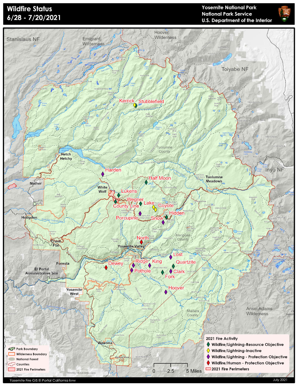
July 27, 2021 - As of June 28th Yosemite, has had 22 fires started by lightning and six human caused fires for the 2021 fire season. Management has taken on a mix of strategies to suppress, monitor or maintain these fires throughout Yosemite's naturally fire-adapted ecosystem. Crews have completed firing operations on Lukens and County Line fires to increase containment and protect White Wolf Lodge and Campground, and Tioga Road. The Porcupine Fire has been contained with handline and will be monitored. Stubblefield, Wegner, and Half Moon are being monitored and have a low probability of spread with many natural barriers. This minimizes suppression impacts in the wilderness while allowing the healthy ecological effects of natural fire. The other 21 fires not reported on in this update have all been suppressed or were called natural outs. Firefighters are routinely monitoring fire behavior on the remaining seven fires and will continue to engage in management actions as warranted.
Yosemite National Park is a fire-adapted ecosystem. The overall strategy for managing all wildland fires is to provide for the safety of employees and the public and protect and enhance natural and cultural resources.
Hoover
Location: Illilouette drainage 8700 elevation.
Discovery Date: July 19,2021 Size: 59.1 ac.
Containment: 100% Strategy: Suppression
Cause: Lightning
County Line
Location: Near Yosemite Creek Campground Road. 8361 elevation.
Discovery Date: June 28, 2021 Size:224 acres
Containment: 100% Strategy: Confine and Contain
Cause: Lightning
Lukens
Location: West of Lukens Lake, North of Tioga Road. 8243 elevation.
Discovery Date: June 28, 2021 Size: 466 acres
Containment: 50% Strategy: Confine and Contain
Cause: Lightning
Porcupine
Location: Northeast of Porcupine Campground, and Tioga Road. 8210 elevation.
Discovery Date: June 28, 2021 Size:10.8 acres
Containment: 100% Strategy: Suppression
Cause: Lightning
Stubblefield
Location: Northern end of Yosemite NP, 2000 feet from Pacific Crest Trail (mile marker 982), no threat to trail. 8000 elevation.
Discovery Date: June 28, 2021 Size: 2 acres
Containment: 0% Strategy: Monitor
Cause: Lightning
Wegner
Location: East of Yosemite Creek Picnic Area and east of Tioga Road. 8256 elevation.
Discovery Date: June 28, 2021 Size: . 5 acres
Containment: 0% Strategy: Monitor
Cause: Lightning
Half Moon
Location: West of Ten Lakes near Half Moon Meadow. 8256 elevation.
Discovery Date: June 28, 2021 Size: 1.5 acres
Containment: 0% Strategy: Monitor
Cause: Lightning
For the most up-to-date fire information follow Inciweb: https://inciweb.nwcg.gov/
Yosemite Fires Map 7.20.2021 PDF printable
-
Air Quality: Yosemite Air Quality Page or airnow.gov or airnow.gov/fires
-
Trail Closures: https://www.nps.gov/yose/planyourvisit/conditions.htm
-
Fire Restrictions: https://www.nps.gov/yose/planyourvisit/firerestrictions.htm
-
National Weather Service Yosemite area forecast: www.weather.gov/hanford
-
Sign-up for Alerts: go.nps.gov/alert
-
Yosemite National Park Fire Information webpage: go.nps.gov/yosefire
-
Facebook: @YosemiteFire
-
Twitter: @YosemiteFire
Source: NPS