
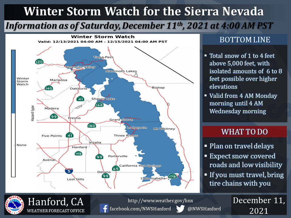
December 11, 2021 - The National Weather Service Hanford Office reports a Winter Storm Watch is in effect for the Sierra Nevada from 4:00 A.M. Monday morning until 4:00 A.M. Wednesday morning.
A Winter Storm Watch means there is potential for significant snow accumulations that may impact travel.
The majority of this snow will fall Monday night and Tuesday.
Travel could be extremely difficult or impossible. If you plan to travel, consider alternate strategies. If you must travel, remember to carry tire chains, plenty of food, a good deal of water, and warm clothing in your vehicle.
For information on road conditions, including closures or delays, call Caltrans at 1-800-427-7623.
Winter Storm Watch
URGENT - WINTER WEATHER MESSAGE
National Weather Service Hanford CA
250 AM PST Sat Dec 11 2021

CAZ323-326>331-111900-
/O.CON.KHNX.WS.A.0008.211213T1200Z-211215T1200Z/
Yosemite NP outside of the valley-Upper San Joaquin River-
Kaiser to Rodgers Ridge-Kings Canyon NP-Grant Grove Area-
Sequoia NP-South End of the Upper Sierra-
250 AM PST Sat Dec 11 2021

...WINTER STORM WATCH REMAINS IN EFFECT FROM LATE SUNDAY NIGHT
THROUGH LATE TUESDAY NIGHT...

* WHAT...Heavy snow possible. Total snow accumulations of 1 to 4
  feet above 5000 feet with localized accumulations up to 6 to 8
  feet possible over high elevations. Winds could gust up to 65
  mph.

* WHERE...Elevations above 5000 feet in the Sierra Nevada.

* WHEN...From late Sunday night through late Tuesday night.

* IMPACTS...Travel could be very difficult to impossible.

PRECAUTIONARY/PREPAREDNESS ACTIONS...

Monitor the latest forecasts for updates on this situation.
Source: NWS