


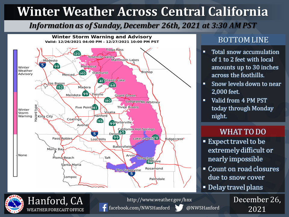
December 26, 2021 - The National Weather Service Hanford Office reports Winter Weather is expected across Central California as Winter Storm Warnings are in effect for the higher terrain of the Sierra Nevada and will go into effect for the Foothills of the Sierra Nevada starting at 4:00 P.M. late this afternoon.
A Winter Weather Advisory will also go into effect for the Kern County Mountains including; Lake Isabella, Frazier Park, Grapevine, and Tehachapi areas from 4:00 P.M. Monday morning through 10:00 P.M. Monday night.
Travel will continue to be extremely difficult or impossible. If you plan to travel, consider alternate strategies.
For information on road conditions, including closures or delays, call Caltrans at 1-800-427-7623 or Caltrans Quick Map.
  Area Forecast Discussion
  National Weather Service Hanford CA
  434 AM PST Sun Dec 26 2021


  .SYNOPSIS...The region will continue to experience an active
  weather pattern today through Wednesday. Heavy snow with
  accumulations as low as 2,000 feet in the Sierra mountains and
  foothills are likely on tonight through Monday. Snow will likely
  impact the Kern County mountain passes on Monday, with an
  additional chance of pass level snowfall on Wednesday. We dry out
  by mid-week with below average temperatures the next seven days.


  &&

  .DISCUSSION...
  Our active weather pattern continued across the district on
  Christmas day. Rain accumulations remained on the light side over
  the valley, with most locations receiving less than one tenth of
  an inch. Heavier accumulations remained in the foothills and
  Sierra with some locations receiving between a half to one inch
  of liquid equivalent as well as over a foot of snow. Latest water
  vapor satellite imagery is showing the main upper low swinging
  through the central California interior. This has allowed for
  current snow levels to drop to around three thousand feet
  according to snow level radars as well as MRMS radar data. Light
  isolated showers will mostly continue over the Sierra today with
  minor accumulations ahead of the next system. Lastly, as this low
  moves through, gusty west winds will continue along the Mojave
  desert slopes through Midnight with wind gusts up to 55 mph likely
  through at least Midnight.

  The next system will begin to impact the region later this
  and evening and will continue through Monday night. For the
  Sierra foothills, including Yosemite Valley, the Winter Storm
  Watch has been upgraded to a Winter Storm Warning effective 4 PM
  PST today through 10 PM PST Monday. Heavy snow accumulations above
  1,500 feet is certain. The NBM is showing a likely (>60%) chance
  of receiving at least 12 inches of snow or more through Monday
  night for elevations as low as 2,000 feet and above.

  For the Kern County mountains, the Winter Weather Advisory is in
  effect from 4 AM PST until 10 PM PST Monday. General amounts of 6
  to 12 inches with isolated amounts up to 18 inches are
  conceivable above 2,000 feet. On Monday, there is a 75% chance of
  seeing at least a trace and a 26% chance of at least one inch
  along the Grapevine. Between 2 to 4 inches is conceivable along
  Tehachapi Pass on Monday. There is a 65% chance of receiving at
  least one inch or greater along Tehachapi Pass on Monday.

  We`ll get a quick break in the action on Tuesday ahead of the next
  upper low to impact the area on Wednesday. Amounts are much
  lighter with this mid-week system with the heaviest precipitation
  amounts in Kern County. However, snow levels will remain around
  pass levels, so this will need to be monitored for any winter
  weather products on Wednesday.


  &&


  .AVIATION...MVFR conditions are likely in and near showers over
  the next 24 hours. Mountain obscurations with areas of IFR
  conditions are expected in the Sierra Nevada through at least the
  next 24 hours.

  &&

  .AIR QUALITY ISSUES...
  None.
Source: NWS
