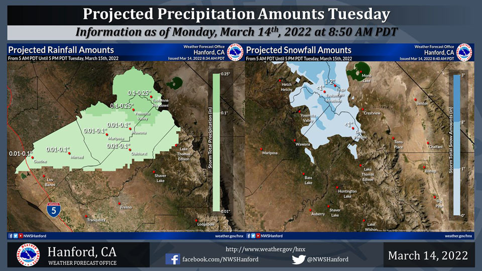
Projected Precipitation for Mariposa 0.01"- 0.10"
Projected Precipitation for Oakhurst 0.01"- 0.10"
Projected Precipitation for Yosemite Valley 0.10"- 0.25"
March 14, 2022 - The National Weather Service Hanford Office reports a cold front will move eastward across Northern California Tuesday.
As a result, light precipitation is possible from Fresno County northward.
One to three inches of snow is conceivable in the Mariposa and Merced County portions of the Sierra Nevada above 7,000 feet.
  Area Forecast Discussion
  National Weather Service Hanford CA
  319 AM PDT Mon Mar 14 2022

  .SYNOPSIS...
  Above normal temperatures today with mostly clear skies.
  Increasing clouds with light precipitation possible from Fresno
  County northward Tuesday. Clearing with a warming trend is
  expected Thursday and Friday. Wet weather is possible throughout
  Central California this upcoming weekend.

  &&

  .DISCUSSION...
  Weak ridging over the area will keep us mostly clear with above
  normal temperatures today. A weakening frontal boundary will
  become parallel to the upper level flow and become stationary
  across the NRN CA on Tuesday. Showers will drift as far south as
  Fresno county. A few hundreths are possible on Tue across the SJV
  Fresno county northward into Madera and Merced counties, with
  around a tenth of an inch of rain in the Sierra near YNP. One to
  three inches of snow is expected above 7k feet on Tuesday. The
  front will weaken as it moves south Tuesday night.

  NW flow aloft on Wed will clear out parts of the SJV but residual
  clouds are expected along the foothills and in the south valley.
  Some light drizzle is possible over the Grapevine and Tehachapi
  passes.

  Clear and warming conditions are expected Thursday and Friday as
  ridging builds over the area. Above normal temperatures are
  expected, especially on Friday, where SJV temperatures will be in
  the upper 70s.

  Saturday and Sunday will be unsettled with a digging trough across
  the CENCAL area. Ensembles/NBM are advertising widespread
  precipitation spreading south across the region Sat morning and
  ending Sunday evening. Up to 10 inches of snow is possible based
  on current guidance above 6000 feet on Saturday, crashing to
  around 3000 feet on Sunday. A tenth to a half an inch of rain is
  possible in the SJV Sat and Sun.

  Precip will end Sunday night with partial clearing on Monday and
  near normal temperatures.

  &&

  .AVIATION...
  VFR conditions will prevail across Central California through at
  least the next 24 hours. Increasing high clouds tomorrow
  afternoon.

  &&

  .AIR QUALITY ISSUES...
  None.
Source: NWS
