


California and National Drought Summary for April 19, 2022
Summary
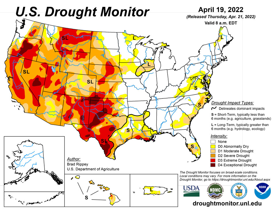
April 21, 2022 - The drought-monitoring period, which began on the morning of April 12 and ended early April 19, featured a powerful spring storm delivering significant, late-season snow from the Cascades and Sierra Nevada to the northern Plains. High winds and blizzard conditions accompanied the snow, especially across the northern Plains. Farther south, drought conditions worsened across portions of the central and southern Plains and the Southwest, amid windy, dry conditions. At times, winds raised dust and contributed to the rapid spread of several wildfires, including the 6,159-acre McBride Fire, which destroyed well over 300 structures after being ignited on April 12 in Ruidoso, New Mexico. Meanwhile, heavy showers and locally severe thunderstorms swept across the Mississippi Delta and environs, producing widespread rainfall totals of 2 to 4 inches or more and causing localized wind and hail damage. Significant rain fell in other areas, including parts of the Midwest and Northeast. During the last 24 hours of the drought-monitoring period, rain swept into the Atlantic Coast States, with some wet snow observed across the interior Northeast. Warm weather prevailed for much of the period in the South and East, while a harsh cold snap engulfed the northern Plains and Northwest. In fact, an extended spell of chilly weather broadly covered the western U.S., as well as the upper Midwest.
Northeast
Widespread precipitation (rain and snow) resulted in modest reductions in the coverage of abnormal dryness (D0) and moderate drought (D1). In addition, moderate drought (D2) was finally removed from northern New England for the first time since mid-June 2021. Binghamton, New York, in a drought-free section of the Northeast, received 11.4 inches of snow on April 19—a record-setting amount so late in the spring. Binghamton also set a 2-day snowfall record for April, with 14.6 inches (previously, 13.6 inches on April 15-16, 2007).
Southeast
Rain moved into the southern Atlantic States at the end of the drought-monitoring period, with only slight impact on the depiction of abnormal dryness (D0) and patchy moderate to severe drought (D1 to D2). Meanwhile, heavier rain fell in Alabama and western sections of Georgia and Florida, reducing or eliminating the coverage of abnormal dryness (D0) and moderate drought (D1).
South
Heavy rain fell across roughly the eastern half of the region, resulting in extensive reductions in the coverage of abnormal dryness (D0) and moderate to extreme drought (D1 to D4). According to a network of volunteer (CoCoRaHS) observers, month-to-date rainfall totals of 6 to 8 inches or more are common across the region. April 1-19 rainfall officially reached 8.51 inches in Arkadelphia, Arkansas; 7.64 inches in Hattiesburg, Mississippi; and 6.70 inches in Troy, Alabama. In stark contrast, moderate to exceptional drought (D1 to D4) continued to worsen in many areas west of a line stretching across eastern sections of Oklahoma and Texas. On April 17, Texas led the U.S. (tied with Montana) with topsoil moisture rated 85% very short to short, according to the U.S. Department of Agriculture. Also, on the 17th, more than three-quarters (81%) of the winter wheat in Texas, along with 80% of the oats and 76% of the rangeland and pastures, were rated in very poor to poor condition. Nationally, 37% of the winter wheat was rated in very poor to poor condition on that date, highest at this time of year since April 14, 1996, when 43% of the crop fell into those two categories. On the southern High Plains, episodes of blowing dust or smoky skies have been common this spring; in Lubbock, Texas, visibilities were sharply reduced in dust on April 12, when a southwesterly wind gust to 60 mph was reported. The south-central U.S. has also experienced periods of extreme heat, with McAllen, Texas, reporting highs of 100°F or greater on April 6, 11, and 13. McAllen’s high of 109°F on April 6 set a monthly record (previously, 107°F on April 26, 1984, and April 27, 2014). However, there have also been cool spells, with Dalhart, Texas, posting a daily-record low of 22°F on April 14.
Midwest
Cool, damp conditions have resulted in widespread spring fieldwork delays. Several daily-record lows were set on April 19, with temperatures falling to 19°F in Cedar Rapids, Iowa; 26°F in Quincy, Illinois; and 32°F in Cape Girardeau, Missouri. The day before, on April 18, daily-record snowfall totals included 1.6 inches in Indianapolis, Indiana, and 2.3 inches in Dayton, Ohio. Among Midwestern States, corn planting had begun by April 17 only in Kentucky (6% sown, versus the 5-year average of 16%) and Missouri (4% sown, versus 12% on average). On the same date, topsoil moisture ranged from 40 to 60% surplus in Illinois, Indiana, Michigan, and Ohio, according to the U.S. Department of Agriculture. Still, there were a few pockets of abnormal dryness (D0) and moderate to severe drought (D1 to D2) mainly across the upper Midwest, with general improvement noted in many areas over the last week.
High Plains
A winter-like storm pounded North Dakota and portions of neighboring states, delivering much-needed moisture but disrupting travel and stressing livestock. Across the remainder of the High Plains, however, windy, dry weather raised dust, resulted in fast-spreading wildfires, and led to a broad increase in the coverage of abnormal dryness (D0) and moderate to extreme drought (D1 to D3). In North Dakota, April 12-14 snowfall included 12.6 inches in Grand Forks (National Weather Service office) and 18.3 inches in Bismarck. Storm-total snowfall topped 2 feet in several North Dakota communities, including Velva (28.0 inches), Lansford (27.5 inches), Dunn Center (26.0 inches), and Underwood (24.3 inches). During the storm, a wind gust to 54 mph was clocked in Bismarck; elsewhere in North Dakota, gusts reached 60 mph in Dickinson and 63 mph in Minot and Hettinger. In the storm’s wake, single-digit low temperatures were common across snow-covered North Dakota, where temperatures fell to 8°F in Minot and Grand Forks. With a low of 0°F on the 16th, Bismarck, North Dakota, experienced its latest-ever reading of 0°F or below—and its coldest April weather since 1996, when it was -1°F on April 5. Temperatures briefly plunged across the central Plains, threatening the already drought-stressed winter wheat crop. Denver, Colorado, registered 10°F on April 13, a record for the date, followed the next day by daily-record lows of 4°F in Sidney, Nebraska, and 9°F in Colby, Kansas. By April 17, the U.S. Department of Agriculture reported that topsoil moisture was rated more than 60% very short to short in each of the region’s states except North Dakota, led by Nebraska (84% very short to short). On the same date, nearly half (48%) of the winter wheat in Colorado was rated in very poor to poor condition. One-fifth to one-third of the wheat was rated very poor to poor in Kansas (31%), Nebraska (27%), and South Dakota (22%).
West
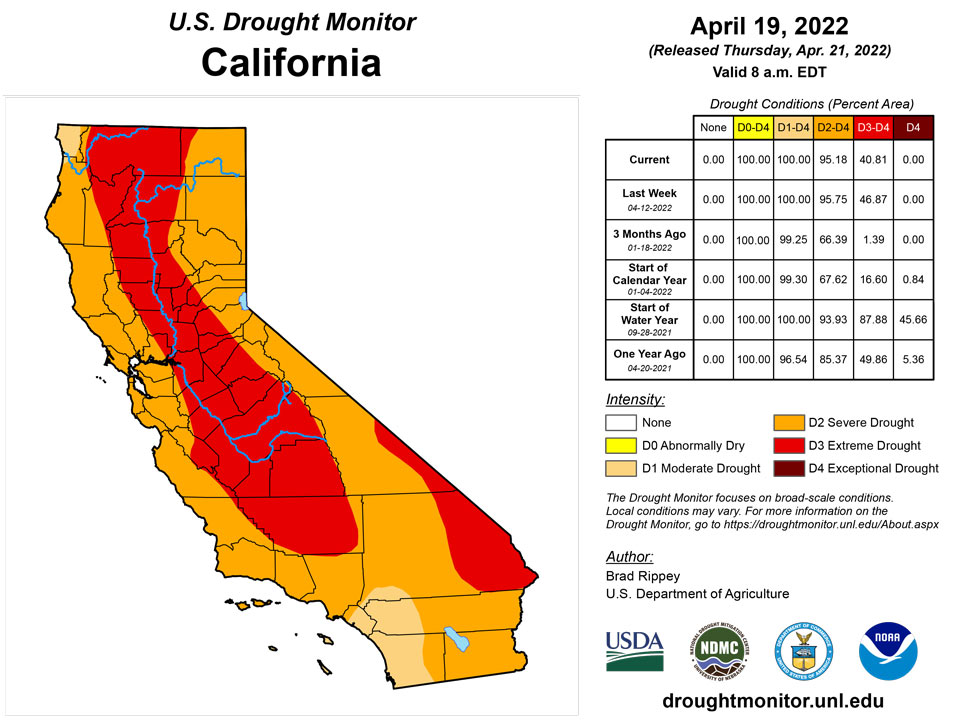
A classic La Niña regime has developed in recent weeks, providing beneficial moisture across northern California and the Pacific Northwest, eastward to the northern Rockies. At the same time, dry, often windy weather has affected the nation’s southwestern quadrant. As a result, deterioration has been observed in parts of the Southwest, particularly in New Mexico. According to the U.S. Department of Agriculture, Montana (85%) led the West in topsoil moisture rated very short to short on April 17, followed by New Mexico (80%). New Mexico, in addition to the McBride Fire, has been dealing with several other blazes, including the 7,573-acre Hermits Peak Fire, which started as a prescribed fire northwest of Las Vegas on April 6 before escaping containment. More recently, the Crooks Fire has been actively burning south of Prescott, Arizona, with numerous evacuations in effect. Farther north, however, the recent spell of cool, damp weather has generally boosted topsoil moisture, has locally improved water-supply prospects, and has provided a late-season boost in high-elevation snowpack. Snow briefly fell at lower elevations, too, with the airport in Portland, Oregon—which had never experienced a measurable April snowfall—receiving 1.9 inches on April 11-12. The airport’s previous latest snow had fallen on March 25, 1965, when 0.3 inch fell. Downtown Portland, hit with 2.0 inches of wet snow on April 11, also set a record for its latest accumulation (previously, 0.1 inch on April 10, 1903). Measurable snow fell in Great Falls, Montana, each day from April 11-17, totaling 12.2 inches. Farther west, the first-ever measurable April snow fell at the agricultural experiment station in Wenatchee, Washington. Incredibly, the Wenatchee Experiment Station received 10.4 inches of snow on April 14, boosting its month-to-date total to 13.1 inches. A neighboring station, the Wenatchee Water Plant, received a storm total of 5.4 inches, breaking its April 1935 record of 0.5 inch. The net effect of the Northwestern precipitation was to result in slight trimming of moderate to extreme drought (D1 to D3). However, there was often a fine line between areas that received beneficial precipitation and those that did not.
Caribbean
In Puerto Rico, patchy abnormal dryness (D0) and moderate drought (D1) persisted in some southern areas, where impacts included poor pasture conditions, low streamflow, and groundwater shortages. Meanwhile, dryness (D0) expanded slightly across central Puerto Rico and persisted along the northwestern coast.
In summary, radar-based estimates of precipitation showed a fourth of an inch or less rainfall falling across the U.S. Virgin Islands this week. Continued dry conditions in April and continued declining groundwater levels kept St. John and St. Thomas in moderate drought and St. Croix in severe drought. Low cisterns and SPI values reflected intensifying short-term dryness (S) which added to the long-term dryness (L) on St. John and St. Croix, while the drought continued at the long-term (L) time scale for St. Thomas.
On St. John, two CoCoRaHS stations had 0.19 and 0.23 inch of rain this week, with month-to-date totals of 0.97 and 1.03 inches. Windswept Beach reported 0.20 inch for the week and 0.77 inch for the month. The long-term weekly average at Windswept Beach is 0.64 inch so we can conclude that these stations were “below normal” for the week; Windswept Beach was also “drier than normal” for the month at 44% of the long-term average. The groundwater level at the USGS Susannaberg DPW 3 Well on St. John continued to decline this week and has steadily declined since early February. It is at the lowest level since 2017. Local reports indicated many cisterns were less than half full, with 50 to 60% of those tested nearly dry. The dry conditions thus far in April pushed the 1-month Standardized Precipitation Index (SPI) into the abnormally dry category, so the drought status for St. John was changed to D1-SL.
Based on available data, the CoCoRaHS stations on St. Thomas had weekly rainfall totals mostly a third of an inch or lower with values ranging from 0.16 to 0.37 inch. King AP recorded 0.24 inch for the week, which is less than half the weekly normal. The month-to-date total of 1.06 inches at King AP is 79% of normal and the year-to-date total is 8.45 inches or 109% of normal. The groundwater level at the USGS Grade School 3 Well on St. Thomas continued to decline this week and has steadily declined since early February. Local reports indicated many cisterns were less than half full, with 50 to 60% of those tested nearly dry. These data and the SPI values support continuation of D1-L.
On St. Croix, the CoCoRaHS weekly precipitation totals ranged from zero to 0.19 inch, with most stations having some missing data. Month-to-date totals at the CoCoRaHS stations range from 0.10 to 0.62 inch. The weather station at East Hill had 0.15 inch for the week, which is below normal, and 0.53 inch for the month to date, which is 43% of normal. Rohlsen AP had no measurable rain for the week; the 0.25 inch for the month is 20% of normal. The groundwater level at the USGS Adventure 28 Well on St. Croix continued to decline this week and has steadily declined for the past year. It is at the lowest level in the 2016-2022 record. The dry conditions thus far in April pushed the 1-month Standardized Precipitation Index (SPI) into the drought category, so the drought status for St. Croix was changed to D2-SL.
Pacific
There were no changes in Alaska, which remained free of dryness and drought. In recent days, cold, dry conditions in eastern Alaska contrasted with mild weather across the state’s western tier.
In Hawaii, rainfall has intensified in recent weeks across many windward locations, while dryness has persisted across most leeward slopes. As a result, the drought gradient has tightened on many of the Hawaiian islands. On the Big Island, for example, the depiction ranges from no dryness across eastern parts of the island to extreme drought (D3) on the leeward Kohala slopes. Hilo (on the Big Island) received 12.94 inches of rain (204% of normal) during the first 19 days of April, while Honolulu, Oahu reported just 0.02 inch (4%).
In summary, for the U.S.-Affiliated Pacific Islands (USAPI), rain this week contributed to the removal of drought and abnormal dryness from the Marianas and improved conditions at Wotje to severe drought. Abnormal dryness continued for Kapingamarangi while the rest of the USAPI remained free of drought and abnormal dryness.
This USDM week was dry (less than the 2-inch weekly minimum required to meet most water needs) in the Republic of Palau, with Airai measuring 0.99 inch of rain and Koror COOP reporting 1.69 inches. But heavy rains from Tropical Cyclone Malakas last week raised the monthly totals to well over the 8-inch monthly minimum, so D-Nothing continues.
In American Samoa, easterly trade winds and orographic showers gave Pago Pago 1.14 inches of rain, Siufaga Ridge 1.66 inches, and Toa Ridge 1.12 inches. These values were below normal, but normals are high at this time of year and the observations were above the 1-inch weekly minimum, so D-Nothing continues for Tutuila.
A monsoon trough in the wake of Malakas brought some showers this week to the Marianas. Rota recorded 5.59 inches of rain for the week, bringing the monthly total to 10.07 inches, which is more than double the 4-inch monthly minimum required to meet most water needs. Guam recorded 1.03 inches for the week, bringing the monthly total to 3.77 inches. In Saipan, the IAP reported 3.69 inches for the week, NPS station 3.99 inches, and ASOS station 3.76 inches; the monthly total was over 5 inches at each station. The rain was enough to end abnormal dryness at Saipan and Guam, so all of the Marianas is now free of drought and abnormal dryness.
In the Federated States of Micronesia (FSM), rain fell in the west from an exiting monsoon trough and in the east from an Inter-Tropical Convergence Zone (ITCZ) and its associated surface troughs. Weekly rainfall totals ranged from zero at Kapingamarangi to 6.13 inches at Pohnpei. Wet (more than the 2-inch weekly minimum) stations included Pohnpei, Kosrae, Lukunor, Nukuoro, Pingelap, and Ulithi. Dry (less than 2 inches) stations included Yap, Chuuk, Kapingamarangi, and Woleai (2 days of observations were missing at Woleai). Rain last week from Malakas (in the west) and the ITCZ (in the east) gave most stations a wet month-to-date, with most monthly totals already over the 8-inch monthly minimum. Exceptions include Lukunor and Kapingamarangi. With dry conditions this week and last week, and a dry month-to-date (only 3.84 inches), D0-S continued at Kapingamarangi. D-Nothing continued for the rest of the FSM stations, except Fananu which could not be analyzed due to lack of data.
The ITCZ and associated surface troughs, trade-wind convergence, and an upper-level trough transitioning to a cutoff low combined to give the Marshall Islands (RMI) a wet week. Weekly rainfall totals at the central and southern islands ranged from 2.96 inches at Jaluit to 8.56 inches at Majuro. Even Wotje received rain. The 1.90 inches for the week at Wotje was below the 2-inch weekly minimum and the month-to-date (4.34 inches) was below the monthly minimum for this time in the month, but the rain was enough to bring water catchment levels to roughly 50% of total capacity and the condition of vegetation was improving. This is the dry time of year for Wotje and Wotje is in the drier part of the RMI, so the 4.34 inches for April 2022 to date ranks as the 12th wettest April compared to full Aprils in the 39-year record. As a result of the improving conditions, Wotje was changed from D3-SL to D2-SL. The remaining stations continued at D-Nothing, except for Utirik which could not be analyzed due to missing data.
Looking Ahead
A parade of Pacific storms will maintain unsettled weather across much of the country during the next several days. One of the most consequential storms will traverse the western U.S. on April 21-22 before intensifying over the northern and central Plains. The storm system will result in similar impacts to those observed last week, including wind-driven snow across northern sections of the Rockies and Plains (mostly on April 22-23); high winds, possible blowing dust, and an elevated wildfire threat over a multi-day period across portions of the central and southern Plains and the Southwest; and a multi-day risk of severe thunderstorms, especially during the weekend from the Plains into parts of the mid-South and Midwest. In contrast, negligible precipitation will fall during the next 5 days along the Gulf Coast, in the Atlantic Coast States, and across the Southwest. The NWS 6- to 10-day outlook for April 26 – 30 calls for near- or below-normal temperatures across much of the country, with the greatest likelihood of cool conditions focused on the Great Lakes States. However, warmer-than-normal weather will prevail from southern California to the central and southern Great Plains. Meanwhile, near- or below-normal precipitation should be observed nationwide, except for wetter-than-normal conditions from the northern Cascades to western North Dakota.
Author(s):
Brad Rippey, U.S. Department of Agriculture
Richard Heim, NOAA/NCEI
Dryness Categories
D0 Abnormally Dry—used for areas showing dryness but not yet in drought, or for areas recovering from drought.
Drought Intensity Categories
D1 Moderate Drought
D2 Severe Drought
D3 Extreme Drought
D4 Exceptional Drought
Drought or Dryness Types
S Short-term, typically less than 6 months (agriculture, grasslands)
L Long-term, typically more than 6 months (hydrology, ecology)
SL Area contains both short- and long-term impacts
Source: National Drought Mitigation Center
