


May 16, 2022 - By Edgar Sanchez - For decades, scientists have poked deep holes a few miles apart across the California landscape, seeking to better understand the 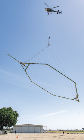 characteristics of the state's 515 groundwater basins in hopes of better managing and protecting them.
Now, California water officials are deploying a new technology—and some new-age, aerial surveillance—to monitor groundwater supplies and aquifer health.
A helicopter, tethered to airborne electromagnetic technology, takes flight from the Lodi Airport. The 100-foot-long hexagonal tool sends signals 1,000 feet into the Earth’s subsurface to determine water levels in aquifers. The data can help develop strategies for groundwater recharge.
Photo/California Department of Water Resources
The technology was demonstrated at the Lodi Airport in Acampo and the Yolo County Airport near Davis in April. Before dignitaries and other onlookers, a California Department of Water Resources helicopter lifted skyward, raising a 100-foot-long, six-sided hoop into the air.
Strangely hovering above the ground like a hollow UFO, the hexagonal tool is able to send electromagnetic signals 1,000 feet into the Earth's subsurface. It then collects data and creates continuous images that can be analyzed to determine the water level present in the aquifer.
"What you are going to see today is called airborne electromagnetic surveying" or AEM, said Karla Nemeth, director of the State Department of Water Resources. With that, she introduced the new groundwater-monitoring technology to reporters who gathered in Davis on April 25. "It's like an MRI for the Earth," she said.
She said the findings from AEM surveys will bring a better comprehension of how to use groundwater basins, "and most importantly, how to put water in them.
"We call that recharge—when we put water into the groundwater basins during really wet periods," Nemeth said.
With California in a third year of drought and surface-water supplies largely vanishing for farmers, the public introduction of this new technology underscored the urgent task of understanding how much water remains in aquifers.
Groundwater accounts for nearly 60% of the state's annual water supply in severely dry years and remains a critical source for agriculture, as tensions peak over how to protect aquifer levels under California's 2014 Sustainable Groundwater Management Act.
"The biggest challenge with California's groundwater basins," Nemeth explained, "is we have a history of withdrawing water, but we don't have the infrastructure to actually recharge those basins when it's wet."
Two Denmark-based contractors are playing key roles in the $12 million Airborne Electromagnetic Survey project. The first is SkyTEM, a geophysical equipment firm that collects the data. The second is Ramboll, an engineering and water management company whose geophysicists process and interpret it.
Katherine Dlubac, the AEM project manager for the Department of Water Resources, said the gathered information is to be shared with local, state and federal agencies and posted online for the public. She said the findings can fill long-standing "data gaps" in knowing what the aquifer system looks like.
For instance, she said, the surveys will pinpoint coarse, grain-dominated materials such as sand and gravels within the aquifers, where most of the water is stored or can easily flow.
"We can also use it to help us find recharge pathways," Dlubac said. Then, during rain events, she said, "we can put the water in a recharge facility and help ensure that it will make its way down to the aquifers" for future use.
The first AEM surveys took place last summer in the Salinas Valley. About 100 California aquifers will be surveyed. Surveys will not be conducted in populated areas or in places with confined livestock.
Having gathered data in the San Joaquin Valley this spring, the AEM project is now focused on the Sacramento Valley, including Yolo County and the Yolo Groundwater Basin.
The technology is welcomed by the Yolo County Flood Control and Water Conservation District, which normally serves local farmers. But the 195,000-acre district in western Yolo County is so dry, it is not planning any irrigation releases for 2022.
"We're very excited for this (AEM) process to take place," said Kristin Sicke, the district's general manager.
The Yolo Subbasin Groundwater Agency is developing a groundwater sustainability plan, and the AEM surveys will "greatly assist" its implementation, she said.
For the past seven years, the district has obtained permits from the State Water Resources Control Board to take excess storm flows at Capay Dam and divert that water through the district's 160 miles of canals. Sicke said the new technology can also bolster that effort.
"We really want to find ways to expand that recharge throughout the subbasin, so receiving this data will be critical to prioritizing...where the soil conditions are best for that," she said.
Paul Gosselin, deputy director of DWR's Sustainable Groundwater Management Office, said the technology demonstrates that "the agencies have put all hands on deck" to meet the challenges.
"These 21st century problems of groundwater management are going to take 21st century technological solutions," Gosselin said.
Also turning out for the demonstration was Bruce Rominger, who owns a diversified farm near Winters. Rominger said he is worried about the continued drought and the suspension of irrigation releases for area farms, including his. "It's a huge problem for us," he said.
But he liked what he saw in the AEM technology.
"It was very interesting," Rominger said. "It's impressive technology to keep track of the groundwater. I think it will be a good thing for us in the future."
Haydn Gaw, pilot of the copter that flies 200 feet above the ground as the AEM technology does its work, said people stop to try to figure out the strange hoop beneath the whirlybird.
"Every time you look down, you see somebody" with a cellphone, filming the helicopter and its unusual payload, he said.
"People are curious," Gaw said, "about what it is."
(Edgar Sanchez is a reporter based in Sacramento. He may be contacted at edgar.chez@yahoo.com.)
ABOUT CALIFORNIA FARM BUREAU FEDERATION
The California Farm Bureau Federation works to protect family farms and ranches on behalf of nearly 32,000 members statewide and as part of a nationwide network of more than 5.5 million Farm Bureau members.
Source: Reprinted with permission CFBF

