


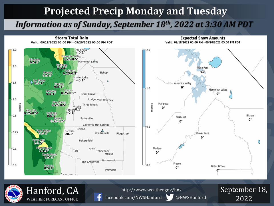
Mariposa Projected Rainfall Totals: 1.00" to 1.50"
Oakhurst Projected Rainfall Totals: 0.50" to 1.00" Changed to 0.25" to 0.50"
Yosemite Valley Projected Rainfall Totals: 0.50" to 1.00" Changed to 0.25" to 0.50"
September 18, 2022 - The National Weather Service Hanford Office reports a storm system will impact Central California later this weekend into early next week.
Little to no precipitation is expected in Kern and Tulare Counties.
Snow levels will be around 8,500 feet to 9,000 feet. Light snow is possible over Tioga Pass Monday morning through Tuesday morning.
The majority of this precipitation will fall throughout the day on Monday.
Area Forecast Discussion
National Weather Service Hanford CA
320 AM PDT Sun Sep 18 2022
.SYNOPSIS...
Cooler temperatures continue ahead of a trough of low pressure
hanging off the California Coast. Well below average afternoon
highs are forecast for Monday. Valley rain and high elevation
snow associated with this system will be possible through the next
couple of days as the system meanders about. The system is
forecast to exit the area by the middle of the week, with a
warming trend forecast to occur later in the week.
&&
.DISCUSSION...
A coastal-hugger type storm system has been slowly dropping
southward over the last 24 hours. Cooler than average conditions
are forecast to occur today and again tomorrow as the system
slowly digs southward. Breezy conditions through the passes of the
west side hills and the Tehachapi Mountains will be likely to
occur this afternoon as onshore gradients tighten, but will likely
remain under advisory criteria. Afternoon highs in the Merced
area today may be as much as 10-12 degrees below normal, with
Fresno and Bakersfield about 3-5 degrees below normal. In terms
of precipitation this evening and through the night, models have
continued towards a drier solution as the system continues to slow
down, and hang a bit further north. Light precipitation
throughout the day today in Merced and Mariposa County may
transition to periods of moderate intensity rain early later
tonight and tomorrow morning as the main rainband associated with
this storm system slowly pushes east.
Through the morning Monday, this band of showers may allow for
some much needed rain across parts of Merced, Mariposa, Madera,
and Fresno Counties, but confidence is limited in how far east
the rainband gets as model solutions trend a bit drier due to a
more north to northwesterly storm track. Currently, NBM guidance
has a 26% chance of a quarter of an inch of rainfall at KFAT for
Monday, versus much higher probabilities near 50% at Merced/MCE.
Probabilities for quarter inch rainfall totals on Monday drop
significantly throughout the southern portion of the San Joaquin
Valley. It's possible the Hanford and Visalia areas only get a
couple hundredths of an inch of rain, with areas such as
Bakersfield and Delano remaining dry Monday and again on Tuesday.
Snowfall chances over Tioga Pass for Monday have also been
decreasing as models latch on towards a more westerly/drier
solution. NBM currently showing a 23% chance of a dusting of snow
for the day Monday, with only a 7% chance of 1 inch of snow in the
same time frame. Expect afternoon highs to be a few degrees
cooler Monday vs Sunday -- especially in Merced and Madera
Counties -- as cloud cover and rain showers linger. Merced may
struggle to get much over 70 degrees Monday. Bakersfield by
contrast won't be affected much by cloud cover and showers, and
may see highs remain in the low to mid 80s.
The NBM has also become more bearish with thunderstorm chances on
Monday afternoon in Merced County. As the system remains further
northwest, the cool air aloft along with better lift also remain
further northwest. The latest run of the NBM has removed t-storm
chances across most of Merced and Mariposa Counties accordingly.
Model guidance shows the low/coastal hugger slowly track eastward
Tuesday and weaken in strength. This solution would allow for
another cool day across the district, with light showery activity
possible through the day, mostly Fresno County and northward.
Light rainshowers and high elevation snow, above 9,000 feet, would
likely end by Wednesday afternoon given current model solutions
that lift the upper trough northwest into NORCAl by early
Thursday. EPS and GEFS ensemble solutions are suggesting a ridging
pattern could emerge after a few days of cool and showery
conditions. This would lead to a warming trend across the region.
Afternoon highs Thursday across the valley could reach the low to
mid 80s on Thursday, upper 80s Friday, and low 90s by Saturday.
NBM guidance is even hinting at highs returning to the mid 90
degree range next Sunday across the valley. Currently, there is an
80-85% probability of exceedance for the 90 degree mark in
Fresno, Hanford, and Bakersfield next Sunday. In other words,
enjoy the cool weather while it lasts!
&&
.AVIATION...
Isolated MVFR conditions due to reduced visibility in showers
across Merced and Mariposa County through the next 24 hours. VFR
conditions will prevail in Central California through at least the
next 24 hours.
&&
.AIR QUALITY ISSUES...
ISSUED: 09/17/2022 14:06
EXPIRES: 09/18/2022 23:59
None.
Source: NWS
