
Temperatures this weekend are on the rise, which combined with gusty north winds in the Sacramento Valley will elevated the fire risk. Wind speeds are expected between 8-18 mph with gusts to around 25 mph. In Southern California record heat is expected.
This weekend CAL FIRE is again urging the public to careful with outdoor activities. Whether it’s camping, barbequing, or off-road driving, conditions are ripe for a simple spark to ignite a wildfire. One Less Spark means One Less Wildfire. Learn more at www.ReadyForWildfire.org.
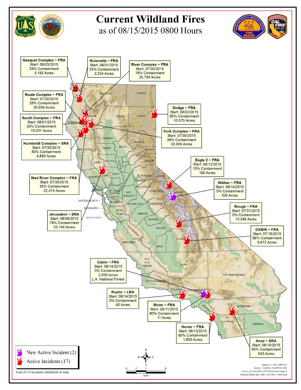
Fires of Interest:
**CAL FIRE Incidents**
Jerusalem Fire, Lake & Napa Counties (more info…)
Jerusalem Grade Road northeast of Middleton
*25,146 acres – 78% contained
*Evacuations in effect
Anza Fire, Riverside County (more info…)
Off Hwy 74, east of Hwy 371 in Anza
*543 acres – 95% contained
Humboldt Lightning Fires, Humboldt County (more info…)
Throughout Humboldt County
*75 fires totaling 4,883 acres – 80% contained
Mark Fire, Calaveras County
South of Angeles Camp
*114 acres – 85% contained
Rocky Fire, Lake, Colusa & Yolo Counties (more info…)
East of Lower Lake
*69,438 acres – 100% contained
**Local Incidents**
Rustic Fire, Ventura County (more info…)
Ventura County Fire Department
Simi Valley area
*198 acres – 50% contained
**Unified Command Incidents**
Fork Complex, Trinity County (more info…)
US Forest Service – Shasta-Trinity National Forest / CAL FIRE
Near the Hayfork area
*32,009 acres – 39% contained (40 fires)
**Federal Incidents**
Cabin Fire, Los Angeles County (more info…) NEW
US Forest Service – Angeles National Forest
Off Hwy 39, 6 miles north of Glendora
*2,500 acres – 0% contained
* CAL FIRE is assisting
Horno Fire, San Diego County (more info…)
Department of Defense
On Camp Pendleton
*1,850 acres – 80% contained
River Complex, Trinity County (more info…)
US Forest Service – Shasta-Trinity National Forest
New River Drainage, near Denny
*35,794 acres – 18% contained
South Complex, Trinity County (more info…)
US Forest Service – Shasta-Trinity National Forest
Near Hyampom, south of Hwy 299
*17,653 acres – 20% contained (6 active fires)
Route Complex, Humboldt & Trinity Counties (more info…)
US Forest Service – Six Rivers National Forest
West of Hyampom
*26,960 acres – 28% contained
Mad River Complex, Trinity County (more info…)
US Forest Service – Six Rivers National Forest
Near Ruth Lake
*22,415 acres – 55% contained
Dodge Fire, Lassen County (more info…)
Bureau of Land Management – Northern California District
*10,570 acres – 95% contained
Nickowitz Fire, Del Norte County (more info…)
U.S. Forest Service – Six Rivers National Forest
*2,254 acres – 53% contained
Gasquet Complex, Del Norte County (more info…)
U.S. Forest Service – Six Rivers National Forest
on the Gasquet Ranger District
*3,192 acres – 29% containment (6 fires remain active)
Cabin Fire, Tulare County (more info…)
US Forest Service - Sequoia National Forest
8 miles northeast of Camp Nelson
*6,672 acres – 96% contained
Rough Fire, Fresno County (more info…)
US Forest Service - Sierra National Forest
2 miles north of the Kings Wild and Scenic River
*13,346 acres – 0% contained