
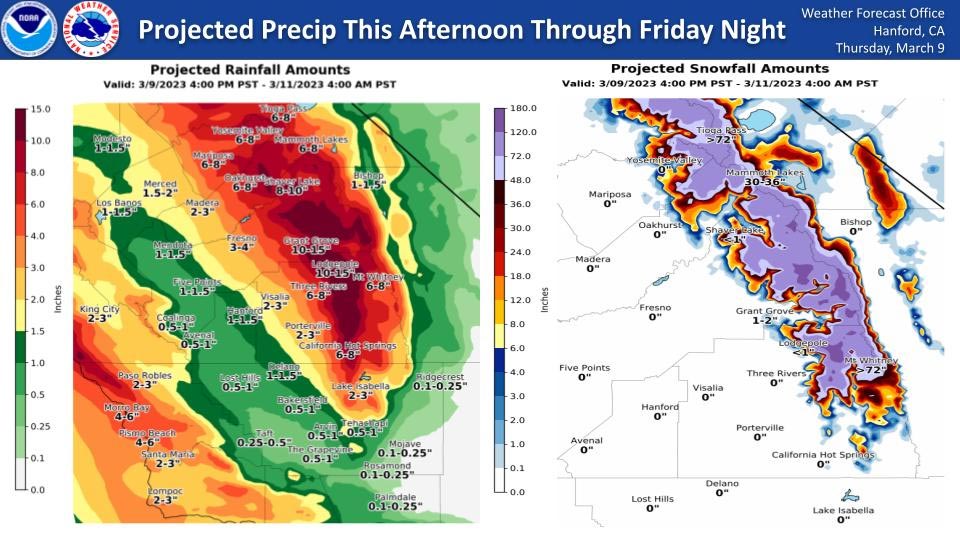
Note: Over the past few days the Weather Service keeps updating this weather system and possible rain totals keep increasing!
Projected Rainfall for Mariposa and Oakhurst 3.00" to 4.00" Now 4.00" to 6.00" Now 6.00" to 8.00"
Projected Rainfall for Yosemite Valley: 3.00" to 4.00" Now 4.00" to 6.00" Now 6.00" to 8.00"
March 9, 2023 - The National Weather Service Hanford Office reports a strong storm system will impact Central California this afternoon through Friday night, resulting in excessive rainfall in most of the San Joaquin Valley, the Sierra Nevada foothills, and the Sierra Nevada below 9,000 feet.
A Flood Watch is in effect.
The majority of this precipitation will fall tonight and Friday.
Area Forecast Discussion
National Weather Service Hanford CA
209 AM PST Thu Mar 9 2023
.SYNOPSIS...
A strong, wet and warm storm will begin to impact our CWA this
Thursday afternoon and will continue through Saturday night. The
bulk of rain and snow will fall from Thursday evening to Friday
evening. This will also bring snow levels up to around 8000ft. The
excessive rainfall below 8000ft and rapid snowmelt below 5000ft
may result in flooding for the majority of our CWA north of the
Kern County Mountains. There may also be another storm system
following on Monday, bringing more rain and high elevation snow.
&&
.DISCUSSION...
The upper level trough sitting over the northeastern coast of the
U.S. will draw in warm moisture from the subtropical Pacific and
push it into the California coast. This will begin Thursday
morning and may bring light precipitation, then increasing through
the afternoon. The bulk of the precipitation will fall from
Thursday evening through Friday night with moderate to heavy rain
and snow over the Sierra Nevada and the foothills. The snow levels
will start at around 6000ft and increase to 8000-9000ft overnight
and through Friday. They will then lower to around 7000ft by
Saturday. The combination of the heavy rainfall and rapidly
rising temperatures will cause rapid snowmelt below 5000ft in the
foothills and range. Rivers and streams will see increased water
levels, which may cause flooding. Wet soil on mountain roads may
lead to rock or mud slides and street flooding is possible in the
San Joaquin Valley. Rain totals from Thursday afternoon to
Saturday morning range from 0.5-1 inch in the western valley to
2-3 inches in the eastern valley. Totals for the foothills range
from 4-7 inches. Snow accumulations of 2 to 4 feet are possible
from 7000 to 8000 feet, 4 to 7 feet from 8000 to 9000 feet and up
to 10 feet above 9000 feet. Precipitation will slow by Saturday
through Sunday morning. There may also be winds at 15 to 25 mph
and gusts around 45 mph in the central San Joaquin Valley north of
Kings County from 4 PM this afternoon to 4 PM Friday, and for the
lower Mojave Desert from 6 AM to 10 PM on Friday.
Another storm system may impact our CWA by next Monday or Tuesday
morning and may last until late Wednesday, model ensembles show
timing differences. It is also not clear if this storm will have
the same intensity as this upcoming system, guidance will become
more confident as more data is added. This will bring more rain
and high elevation snow as snow levels will remain around 6000ft.
&&
.AVIATION...
Areas of mountain obscuring IFR conditions in precipitation after
18Z Thursday. Local MVFR in showers across the San Joaquin Valley
after 18Z Thursday. Otherwise, VFR conditions will prevail across
Central California for the next 24 hours.
&&
.AIR QUALITY ISSUES...
ISSUED: 03/08/2023 13:55
EXPIRES: 03/09/2023 23:59
None.
&&
.CERTAINTY...
The level of certainty for days 1 and 2 is high.
The level of certainty for days 3 through 7 is medium.
Certainty levels include low...medium...and high. Please visit
www.weather.gov/hnx/certainty.html for additional information
and/or to provide feedback.
&&
.HNX WATCHES/WARNINGS/ADVISORIES...
Wind Advisory from 6 AM to 10 PM PST Friday for CAZ337-339.
Flood Watch from this afternoon through Sunday morning for
CAZ300>336.
Wind Advisory from 4 PM this afternoon to 4 PM PST Friday for
CAZ300>306.
Winter Storm Warning from 4 PM PST this afternoon to 10 AM PDT
Sunday for CAZ323-326>331.
Source: NWS