
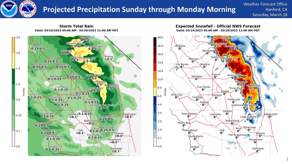
Projected Rainfall for Mariposa and Oakhurst 1.00" to 1.50"
Projected Snowfall for Mariposa: 0"
Projected Snowfall for Oakhurst: 0"
Projected Rainfall for Yosemite Valley: 1.50" to 2.00"
Projected Snowfall for Yosemite Valley: Less than an inch.
Updated on Sunday Morning:
Weather Service Updates Central California Projected Precipitation Totals for Sunday Through Monday Morning Weather System Has Yosemite Valley Now With Up To 1.5 Inches of Rain
March 18, 2023 - The National Weather Service Hanford Office reports the latest precipitation totals for Sunday through Monday morning.
The San Joaquin Valley could see up to an inch of rain while high Sierra elevations could see 1-3 inches of rain, and the Sierra could see 6-12 inches of snow in some places.
Snow levels will start at 5,500 feet on Sunday, peak at 6,800 feet late Sunday night, and end at 4500 feet on Monday morning.
Area Forecast Discussion
National Weather Service Hanford CA
257 PM PDT Sat Mar 18 2023
.SYNOPSIS...Dry weather and light winds continue through
tonight,then a storm system will bring light to moderate
precipitation on Sunday into Monday morning. A stronger and colder
system will impact the region late Monday night through
Wednesday. Periods of moderate to heavy precipitation and gusty
winds are expected, with the brunt of the event likely on Tuesday.
Another storm system may impact the area by the end of next week.
&&
.DISCUSSION...
The dry and mild weather conditions continue across central
California today with afternoon high temperatures on track to top
out a few degrees above normal for this time of year. Wetter and
cooler weather is set to return by early Sunday as a shortwave
trough approaches the California coast.
By early Sunday morning, precipitation will begin pushing into the
central California interior and will continue over the area into
the evening, with showers continuing over the mountains into
early Monday morning. This first round of precipitation will bring
around 1/10 of an inch or less of rainfall to the south end and
west side of the San Joaquin Valley and around 1/4 to 1/2 inch
toward the east side and lower foothills. Snow levels will rise
to around 7500 feet with this system, foothill/mountain locations
below the snow line can expect as much of 1 to 2 inches of
rainfall. Higher Sierra elevations will receive around 1 to 2 feet
of additional snowfall through Monday morning, and a Winter Storm
Warning has been issued for the Sierra Sunday morning through
Monday morning.
There will be a short break during the day Monday, with just some
light precipitation, ahead of the next approaching storm system
which will bring more moisture but lower snow levels. This system
will begin to push into the California coast by Tuesday morning
and will swing inland through Wednesday. Current guidance shows
around 0.5 to 1.5 inches of rain in the San Joaquin Valley and up
to 2.5 inches in the foothills Tuesday morning through Wednesday.
Snow levels with this system will be lower, beginning around 4500
to 5500 feet Tuesday and lowering to around 3000 to 35000 feet by
Wednesday morning as precipitation tapers off. Snow accumulations
up to two to four feet are expected from this storm system. As the
snow levels lower by Wednesday morning, frozen precipitation may
impact the Kern County mountain highway passes. Blended model
guidance currently suggests a 10 to 20 percent probability of at
least 1/10 of an inch of snow there.
Thursday will bring a brief break in the weather ahead of another
system possibly impacting the region by the end of next week.
&&
.AVIATION...Expect areas of MVFR with local IFR and mountain
obscurations as precipitation moves into the region after 10Z
Saturday. Otherwise, VFR conditions will prevail across the
central CA interior during the next 24 hours.
&&
.AIR QUALITY ISSUES...
None.
&&
.CERTAINTY...
The level of certainty for days 1 and 2 is medium.
The level of certainty for days 3 through 7 is medium.
Certainty levels include low...medium...and high. Please visit
www.weather.gov/hnx/certainty.html for additional information
and/or to provide feedback.
&&
.HNX WATCHES/WARNINGS/ADVISORIES...
Winter Storm Watch from late Monday night through Wednesday
afternoon for CAZ318-320-322>331.
Winter Storm Warning from 5 AM Sunday to 11 AM PDT Monday for
CAZ323-325>331.
Source: NWS