


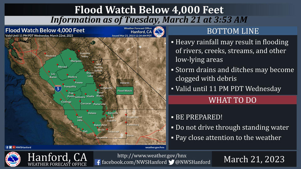
Includes Fresno, Merced, Madera and Mariposa Counties
March 21, 2023 - The National Weather Service Hanford Office reports water levels are extremely high on area rivers, creeks, and streams.
Heavy rainfall below 4,000 feet could cause flooding or worsen ongoing flooding today into Wednesday night.
The heaviest rainfall is expected this afternoon and this evening.
Area Forecast Discussion
National Weather Service Hanford CA
256 AM PDT Tue Mar 21 2023
.SYNOPSIS...
Precipitation chances are quickly ramping up this morning and
rain and snow will fully envelope the area shortly after sunrise.
Precipitation will persist through today, into tonight, and on
into Wednesday. Flooding concerns continue through this time
period while additional significant snowfall accumulations take
place for the Sierra Nevada. Mostly calm weather returns Thursday
into the weekend. A seemingly weaker system continues to linger at
the end of the forecast period next week that we are monitoring.
&&
.DISCUSSION...
Precipitation is quickly arriving this morning and will continue
to overtake the area over the next couple hours. The entire CWA
should be enveloped shortly after sunrise.
Overall, not much was changed in the forecast package from the
previous. New model guidance is locking in on enhanced
precipitation on the windward side of the Sierra Nevadas where
upslope enhancement will help generate high QPF amounts. Some of
the highest elevations now near 5 inches in QPF. That QPF, just
as a 10:1 ratio would result in nearly 50 inches of snowfall...so
the forecast for another large snowfall remains VERY valid.
QPF for the remainder of the CWA remains mostly the same with just
variable shifts. This is due to the overall variability that we
will see in coverage later today when rain activity becomes more
convective in nature. That said, don't be surprised to at least
hear some thunder this afternoon/evening both in the valley and
the mountains. In terms of probabilities, the valley still holds a
~50-75% chance of receiving at least half an inch of rainfall.
However, the probability of reaching an inch quickly falls off.
Any locations there that receive greater than half an inch would
have to be trapped under training convection later today...which
can't be ruled out. Finally bearing in mind the terrain
enhancement previously mentioned, ample rainfall in the lower
elevations of the mountains below the snow level will serve as
the greatest culprit to causing flooding issues once again.
Weather conditions quickly start to improve by Thursday. That
said, persistent NW flow aloft will result in continued snow
showers in the mountains for Thursday and Friday. Likewise, this
pattern will keep below normal temperatures going for the entire
region. A weak disturbance is expected to follow within the upper
level flow as well, bringing an uptick in snow production for the
weekend. A non Pacific trajectory means this system will lack any
significant moisture availability.
Long term focus beyond this mid week system now rests on the
beginning of next week with another system looming. Ensemble
guidance is in decent agreement for this time range that this
system will have better access to the Pacific, meaning greater
moisture to work with. Stay tuned for updates...
&&
.AVIATION...
Generally expecting VFR conditions to persist...though some brief
sub VFR ceilings are possible ~12Z. Ceilings will improve slightly
as we near the afternoon today. As precipitaton becomes more
convective this afternoon and evening, staring around 18Z, there
is the chance that precipitation at TAF sites could become heavy
enough to reduce visibilities below 6 miles. Outside the
valley/beyond standard TAF sites, IFR and LIFR ceilings and
visibilities expected near and in the Sierra Nevada.
&&
.AIR QUALITY ISSUES...
ISSUED: 03/20/2023 13:52
EXPIRES: 03/21/2023 23:59
None.
&&
.CERTAINTY...
The level of certainty for days 1 and 2 is high.
The level of certainty for days 3 through 7 is low.
Certainty levels include low...medium...and high. Please visit
www.weather.gov/hnx/certainty.html for additional information
and/or to provide feedback.
&&
.HNX WATCHES/WARNINGS/ADVISORIES...
Wind Advisory from 11 AM this morning to 5 AM PDT Wednesday for
CAZ337>339.
Flood Watch through Wednesday evening for CAZ300>322-332.
High Wind Warning until 9 PM PDT this evening for CAZ300-308-313-
334>336.
Wind Advisory until 9 PM PDT this evening for CAZ301>307-309>312-
314>317-319-321-332-333.
Winter Storm Warning until 11 PM PDT Wednesday for CAZ318-320-
322>331.
Source: NWS
