


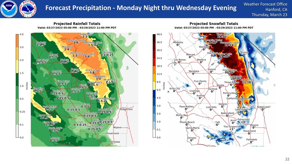
Projected Rainfall for Mariposa 3.00" to 4.00"
Projected Rainfall for Oakhurst 2.00" to 3.00"
Projected Rainfall for Yosemite Valley: 3.00" to 4.00"
Projected Snowfall for Yosemite Valley: 8" to 12" inches
Area Forecast Discussion
National Weather Service Hanford CA
114 AM PDT Thu Mar 23 2023
.SYNOPSIS...
Notably drier weather expected for Thursday, though lingering
moisture will provide some isolated to scattered shower activity
especially at higher elevations. Strong winds are expected for
the Mojave Desert Slopes. The mostly settled weather will persist
into the weekend and even into the start of next week with just
mountain showers persisting. Another storm system lingers in the
extended forecast for early to middle of next week that looks to
bring additional rain and snowfall.
&&
.DISCUSSION...Notably more settled weather arrives today with the
earlier weather system moving east. Lingering moisture behind
this system combined with persisting NW flow will allow for some
additional isolated to scattered shower activity today, as well
as some stronger downsloping winds for the Mojave Desert Slopes
(wind advisory out for this). Temperatures remain below normal and
skies start showing notable clearing late in the day.
The lingering moisture and flow pattern will actually persist for
some time again allowing for isolated to scattered shower
activity for Friday as well. That activity will be more confined
to the higher elevations though. Clearer skies are expected for
the valley, though temperatures will continue to remain below
normal.
Over the weekend, temepratures do start to moderate slightly.
Upper level flow over the western US remains out of the NW,
limiting any real warming though. Likewise, a disturbance is
expected to hitch a ride within this flow. Because of it's
trajectory, moisture is limited as it will remain land locked and
not be able to tap into the Pacific. Overall, it'll just bring an
uptick in mountain snow showers later Saturday into Saturday
night.
Next week we are monitoring yet another system that will bring
widespread rainfall and heavy snowfall for the Sierra Nevadas.
Ensemble guidance probabilities are pretty confident in at least 2
inches of QPF translated to snowfall for the mountains. For the
valley, probabilities are pretty high for half an inch in QPF but
quickly fall off in confidence of reaching an inch. Looking at ENS
and NAEFS standardized anomaly tables for the system next week are
very interesting as they are less than notable with the PWAT
analysis for the period and struggle to exceed even 1 standard
deviation...a far cry from the past several systems that often ran
3+. Will continue to monitor.
With the system next week, increasing SW flow ahead of the system
will bring some notable warming just ahead of the system so right
now Monday looks to try and get closer to normal...right before
temperatures drop again for the middle of the week.
&&
.AVIATION...
Lingering MVFR clouds are expected through at least this morning
for the valley, and thus all TAF sites. By the afternoon, ceilings
should start to rapidly improve and widespread VFR conditions
return.
&&
.AIR QUALITY ISSUES...
ISSUED: 03/22/2023 15:04
EXPIRES: 03/23/2023 23:59
None.
&&
.CERTAINTY...
The level of certainty for days 1 and 2 is medium.
The level of certainty for days 3 through 7 is medium.
Certainty levels include low...medium...and high. Please visit
www.weather.gov/hnx/certainty.html for additional information
and/or to provide feedback.
&&
.HNX WATCHES/WARNINGS/ADVISORIES...
Wind Advisory from 5 PM this afternoon to 8 AM PDT Friday for
CAZ338.
Source: NWS
