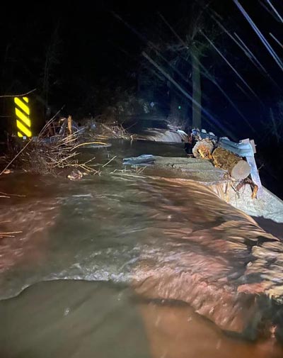
March 26, 2023 - By Julissa Zavala - Above average rainfall has been recorded in the Fresno area this season, and forecasts show the potential for even more wet weather. Flood damaged road in Mariposa County. Credit: Mariposa County Sheriff's Office
Meteorologist Brian Ochs with the National Weather Service in Hanford said atmospheric river events like the ones that hit this season are cyclical and can be expected every five to six years, though some are stronger than others.
Experts like Cordie Qualle, a lecturer in the Lyles College of Engineering at Fresno State, said the storms this season are somewhat reminiscent of a series of storms that pummeled California as the calendar flipped from 1996 to 1997 and led to flooding in the Central Valley and other parts of California.
According to the California Department of Water Resources, that storm series, known as a “pineapple express,” channeled an atmospheric river from warm waters near Hawaii to California and drenched the Sierra foothills with up to 40 inches of precipitation in some locations.
The pineapple express caused levee failures in multiple rivers and flood channels, including the San Joaquin River — the longest river in the San Joaquin Valley.
Qualle recalls the storm resulted in the rapid filling of Millerton Lake, causing water to spill over the dam. “All of a sudden, the water came roaring down the San Joaquin River canyon,” he said. “They had the spillway gates completely open, and the water went over the spillway.”
A historic 59,000 cubic feet of water per second cascaded down the river. The effects were devastating, flooding farmland, towns, communities, and highways from the San Joaquin Valley up to Sacramento.
Qualle said there is a lot of uncertainty with these types of weather events, so it puts the dam operators in a difficult position.
“If they hold back water, then they don’t have the flood storage,” he said, “But if they don’t hold the water back and they don’t get this huge snowmelt, then they are accused of letting the water just flow. It puts them at a huge disadvantage.”
Water management and the need for infrastructure
Whether or not any potential storms may be warm enough or we have a sudden change in weather to cause excessive runoff, water experts believe we should be prepared.
“Let’s say we don’t get that huge runoff that we thought we were going to get from these storms, but then in May there’s a period of 110 degrees for two weeks. Basically, you have the same problem,” Qualle said. “Super-hot early spring weather patterns can create just as much havoc as a warm rainfall. If it doesn’t happen now, there’s a possibility that it could happen later.”
To avoid what could be a catastrophic flooding event, the state needs to improve water infrastructure, said Laura Ramos, associate director for the research and education division at the California Water Institute.
“Our current infrastructure was built for a climate that is not what we have right now. It was built for a population that isn’t what we have right now,” Ramos said. “The climate is changing, and we have way more people now. If history tells us this happens every so often, and we’re not ready, we need to get ready for the next one.”
Both Ramos and Qualle agree that the current infrastructure is outdated and isn’t prepared to absorb and move the large quantity of water that can come down if a warm atmospheric river occurs or we experience hot spring weather. Moreover, Ramos said climatologists are predicting that we will see more precipitation in the form of rain instead of snow in the years to come.
“Fixing damaged infrastructure, new infrastructure and expanding infrastructure is needed,” Ramos said. “A lot of projects take years to get going, so we have to plan now for something that might happen in 10 years.”
With proper infrastructure, Ramos said California would be better prepared to capture water during wet years and put it into water banks or recharge basins for groundwater recharge.
“If we could develop the infrastructure to capture a portion of the flows from these massive events for groundwater recharge it would help balance our groundwater situation,” Qualle said. “Maybe we can’t capture all of it, but if we could capture 5,000 to 10,000 cubic feet per second it would be better than losing it and capturing that flow has the added benefit of reducing the flooding risk downstream on the San Joaquin River.”
Source: Fresno State


