
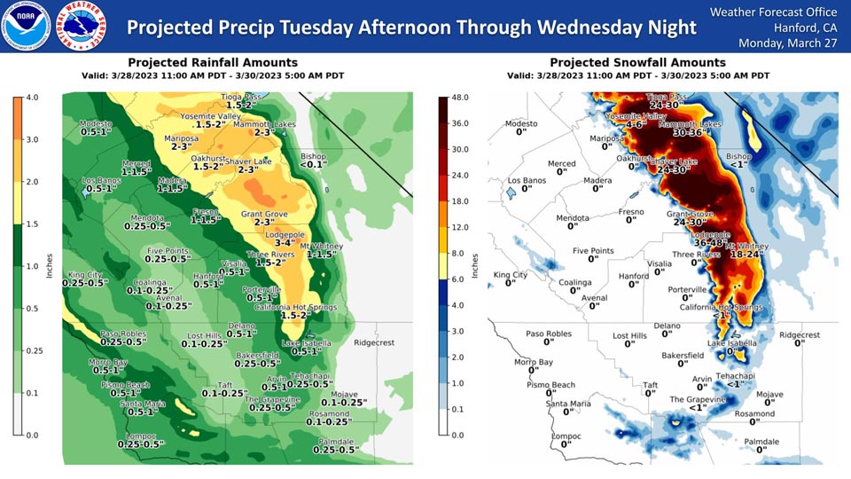
Projected Rainfall for Mariposa 3.00" to 4.00" Now 1.50" to 2.00" Update on Monday afternoon: 2.00" to 3.00"
Projected Snowfall for Mariposa: 0"
Projected Rainfall for Oakhurst 2.00" to 3.00" Now 1.50" to 2.00"
Projected Snowfall for Oakhurst: Less than 1" Update on Monday afternoon: 0"
Projected Rainfall for Yosemite Valley: 3.00" to 4.00" Now 1.50" to 2.00"
Projected Snowfall for Yosemite Valley: 8" to 12" inches Now 12" to 18" Update on Monday afternoon: 4" to 6"
Extreme winter storm impacts are expected in the Sierra Nevada.
The majority of this precipitation will fall Tuesday evening and Tuesday night.
Area Forecast Discussion
National Weather Service Hanford CA
220 PM PDT Mon Mar 27 2023
.SYNOPSIS...
Expect dry and mild conditions today, then turning wetter and a
bit cooler Tuesday and Wednesday, as a storm system is forecast
to impact the region with rain and mountain snow. Becoming windy
on Tuesday during storm passage. Lingering mountain showers are
possible on Thursday before drier and warmer conditions return for
the end of the week.
&&
.DISCUSSION...
Another dry and sunny day across the Central California Interior
was felt today as temperatures remained on the cooler side.
While temperatures stayed below seasonal normal values, another
storm approaching the area from the north will help to knock down
temperatures in the coming days. Visible satellite imagery is
already showing clouds and precipitation crossing into Northern
California as the storm approaches the Northern California Coast.
Clouds will help maintain some higher overnight lows (well above
freezing) with minimal rise during the afternoon hours. Therefore,
the potential for near freezing conditions to lower as the next
storm is expected to enter Central California during the day and
become heavy at times later in the day. Timing of the next Winter
Storm will have the bulk of its energy hit the Central California
Interior later on Tuesday with significant precipitation.
Model guidance is placing the next winter type storm over Central
California on Tuesday with high confidence of it becoming a high
impact event. Ensemble forecast are showing minimal error in how
variable the precipitation amounts can be during the storm event.
With model and satellite moisture analysis leaning in the
direction of forcing a plume of moisture toward the district on
Tuesday, hazardous weather products are currently in play for
possible flooding from heavy rain and heavy snow that we could
expected through early Wednesday morning. At this point, some
index values are showing very high confidence levels that the area
will see abundant water to further the problem of flooding across
the Central California region. As the passage of the storm occurs
on Tuesday, winds will an increase in speeds as gusts could reach
30 mph across area from Merced County down to areas in Kings and
Tulare Counties. The highest terrain of the Sierra Nevada will
also see strong winds on Tuesday.
Longer range Cluster Analysis is showing a strong signal toward the
continuation of the unsettled pattern over the West in Wednesday.
With some clearing as the Atmospheric River shifts south of the
district, the threat of convective activity than increases. Models
place a lobe of cold air aloft over the district on Wednesday
which should support convective storms over much of the valley and
lower foothills. The cold air aloft will also support the return
of low snow levels which may limit the amount of rain in the
foothills and lower the flooding (from rivers) potential.
Afterward, the flow pattern will support the return of dry weather
will minimal increase in temperatures The flow will keep
conditions below normal but, also keep the area dry.
&&
.AVIATION...
VFR conditions will prevail for the next 24 hours.
&&
.AIR QUALITY ISSUES...
None.
&&
.CERTAINTY...
The level of certainty for days 1 and 2 is high.
The level of certainty for days 3 through 7 is medium.
Certainty levels include low...medium...and high. Please visit
www.weather.gov/hnx/certainty.html for additional information
and/or to provide feedback.
&&
.HNX WATCHES/WARNINGS/ADVISORIES...
Winter Storm Warning from 8 AM Tuesday to 11 PM PDT Wednesday
for CAZ318-320-322>331.
Source: NWS