


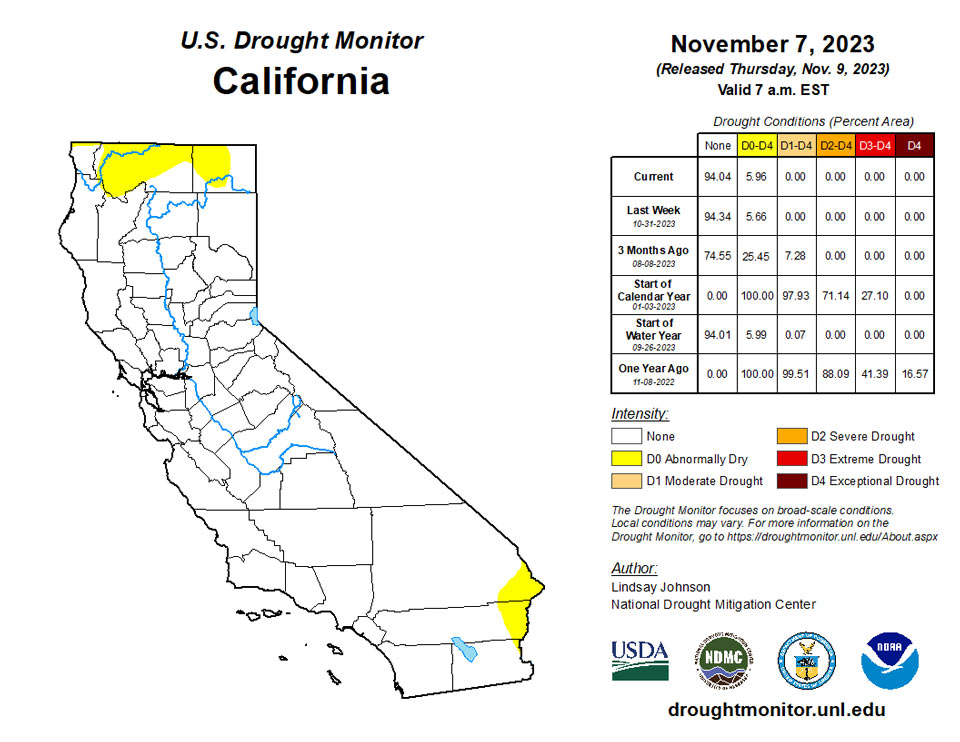
California and National Drought Summary for November 7, 2023
Summary
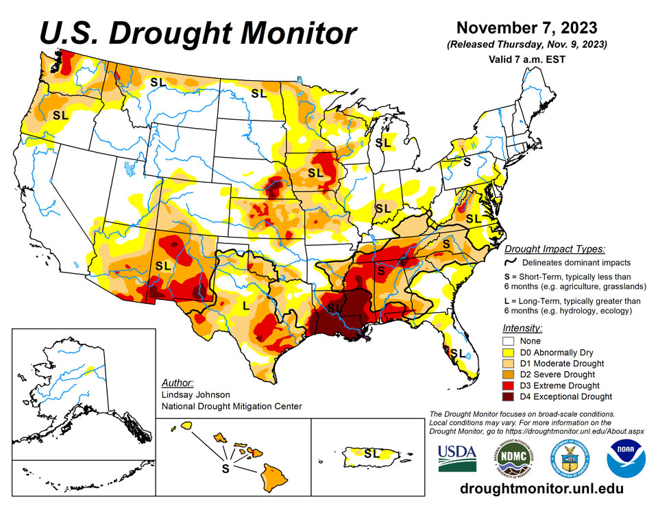
November 9, 2023 - Residual impacts from the prior week’s storm continued to bring some improvements to the Pacific Northwest, northern Plains and upper Midwest. However, in the South and Southeast, conditions continue to rapidly deteriorate, leading to flash drought and widespread expansion of drought conditions.
Northeast
Temperatures were 2 to 4 degrees cooler than normal over the entire region, except for eastern New York. The moisture coming down from Canada largely missed the Northeast, leading to slightly below-normal precipitation. Central and western Pennsylvania, Maryland and West Virginia received 5-25% of normal precipitation. Low soil moisture levels and precipitation deficits for the last few months led to abnormally dry (D0) expansion across eastern West Virginia, most of Maryland, southern Pennsylvania and south-central New Jersey.
Southeast
Flash drought conditions continue to ramp up across the Southeast. Despite temperatures being well below normal, the lack of precipitation continues to compound low streamflow levels and dry soils, leading to continued degradations. Conditions observed in Louisiana and Mississippi have continued eastward across Alabama, western Georgia and Florida’s panhandle and Big Bend. In the southeastern Florida peninsula, conditions that had seen some improvement from the past two to three months of precipitation are now seeing regressions back to summer month conditions. Rapid drying continues along the Atlantic coast from South Carolina to Virginia as flash drought expands across the Southeast. South Carolina saw 1-category degradation across the state, except in the Midlands where good topsoil moisture and medium streamflow levels are being observed. Dry soil moisture and precipitation deficits led to Moderate and Severe Drought expansion and the introduction of Extreme Drought in the Piedmont region. North Carolina saw the same dry patterns as South Carolina, which brought Moderate Drought expansion. Virginia, with similar conditions to South and North Carolina, saw the introduction of Extreme Drought to the Shenandoah Valley.
South
Dry conditions continued across the South, with the entire region at or below 25% of normal precipitation. Despite this lack of precipitation, there was some relief in terms of temperatures, which were 2-4 degrees below normal. Areas of Louisiana and Mississippi were up to 8 degrees below normal. Louisiana and Mississippi did not see any drought relief, with 1-category degradations across the two states. In Louisiana, over 50% of the state is in Exceptional Drought, and in Mississippi rapid deterioration spilling eastward from Louisiana resulted in 1-category degradations. Tennessee is also in Extreme Drought, and Exceptional Drought was introduced along the tri-state border, along with Alabama and Georgia. Extreme and Severe drought also migrated northward. Texas and Oklahoma remained largely unchanged, with some improvements in central Texas and status quo conditions for Oklahoma.
Midwest
Precipitation was nonexistent across the Midwest, with trace amounts falling in the lower regions and some of the snow from Canada reaching the northernmost parts of the Midwest. The northern regions of Minnesota and northwestern Wisconsin had improvements due to the precipitation that missed much of the rest of the Midwest. Otherwise, there was very little change for the region, with 1-category degradations in Iowa, Missouri, Illinois, eastern Wisconsin and southeastern Kentucky. Temperatures were generally near or below normal, except for most of Iowa and southwestern Minnesota.
High Plains
Dry conditions persisted across the High Plains where temperatures are above normal, with Wyoming and Colorado seeing temperatures of 3-8 degrees above normal. The eastern boundary experienced near- or slightly-above-normal temperatures, except for North Dakota where temperatures were 3 or more degrees below normal. South Dakota and northeastern Nebraska continued to see improvements as remnants of the past week’s precipitation aid in dry conditions. There were 1-category improvements along the eastern South Dakota and northeastern Nebraska borders. Areas in South Dakota are so wet that producers have reported issues with planting winter crops.
West
An atmospheric river cascaded over parts of the Pacific Northwest, bringing several inches of new rain and snow accumulation along with last week’s precipitation. With this continued influx of precipitation, modest 1-category improvements were made across the northwest, particularly on the windward side of the Cascade Range. Further improvements were seen in northern Idaho and Montana, which received up to 4 inches of precipitation in some areas. Despite the deluge of precipitation over the last one to two weeks, temperatures have been 1-3 degrees above normal, and south-central Montana even had temperatures of 6-9 degrees above normal. The remaining states in the West remained status quo.
Caribbean
No changes were made in Puerto Rico this week.
Across the U.S. Virgin Islands, no changes were rendered to the current drought depictions. The island of St. Thomas received only light showers this past drought week (Nov 1-7, 2023). CoCoRaHS rainfall reports included 0.32-inch of rain at VI-ST-5 (Charlotte Amalie West 4.2 WNW), 0.24-inch of rain at VI-ST-13 (Charlotte Amalie 1.2 NNW), 0.20-inch at VI-ST-15 (Charlotte Amalie West 1.3 N), 0.02-inch at VI-ST-14 (Nadir 0.3 E, Tropical Marine), and a trace of precipitation at VI-ST-1 (Anna’s Retreat 2.5 ESE). The Grade School 3 well level fell 1.25 feet during the week, beginning with a depth of 3.80 feet below the land surface, and ending with a depth of 5.05 feet.
St. Croix reported a significantly wetter week than did St. Thomas, but it was not enough to improve the current drought depiction of D2-L. Rainfall observations included 1.82 inches at VI-SC-25 (Christiansted 4.4 W), 1.65 inches at VI-SC-23 (Christiansted 6.5 W), 1.21 inches at VI-SC-10 (Christiansted 1.6 E), 1.19 inches at VI-SC-20 (Frederiksted 1.7 ESE), and 1.18 inches of rain at VI-SC-29 (Frederiksted 2.5 NNE). For the month of October, the UVI Sheep Farm observed 11.51 inches of rain. Standardized Precipitation Index (SPI) values suggest a nod toward some improvement in the shorter-term, but the SPI does not take into account groundwater considerations. Though the USGS Adventure 28 Well water level rose slightly this week (from 34.59 to 34.47 feet), the Well is in far worse shape than it was last year at this time, despite the recent rainfall. Concerns regarding groundwater and water-quality issues precludes improving St. Croix’s drought depiction at this time.
Rainfall measurements at St. John this week included 1.62 inches at VI-SJ-5 (Cruz Bay 1.6 E), and nearly an inch (0.96-inch) at VI-SJ-3 (Windswept Beach) where a strong vegetative response to the heavy rainfall over the past few weeks has been noted. VI-SJ-9 (Trunk Bay 0.2 W) measured only 0.06-inch of precipitation this week. The Susannaberg DPW-3 Well rose over a foot this week, from 9.53 feet to 8.47 feet. Drought-free conditions continue for St. John.
Pacific
There were no changes made in Alaska this week.
More degradations took place in Hawaii on Oahu. Despite the recent cold front, conditions continue to degrade, with stations breaking record-low precipitation and streamflow levels.
Surface troughs, weak cyclonic circulation centers, and somewhat drier trade wind flow dominated the USAPI region during the past drought week (Nov 1-7, 2023). On November 3rd, NWS Guam noted a circulation southeast of the Marianas that was accompanied by scattered showers, isolated thunderstorms, and infrequent lightning. However, no significant tropical cyclones developed during this period. Quantitative Precipitation Estimates (QPE) based on SPoRT IMERG satellite imagery showed 7-day rainfall totals ranged from approximately a quarter to half-inch of precipitation over the Marianas to widespread 1-4 inch amounts over much of the Republic of the Marshall Islands (RMI) and the Federated States of Micronesia (FSM). South of the equator, American Samoa received between about one-half and three-quarters of an inch of rain.
In the Republic of Palau, the International Airport (Airai) reported only 0.41-inch of rain this past drought week, and the Koror COOP observed 0.70-inch of rain (though 5 days were missing). Total precipitation amounts for the month of October were 12.80 inches and 9.17 inches, respectively. Palau continues to enjoy drought-free conditions.
Across the Commonwealth of the Northern Mariana Islands (CNMI), drought-free conditions continued. Selected stations with observed rainfall amounts for the past week included Saipan (1.14 inches at a manual rain gauge located at the International Airport; and 1.04 inches at an ASOS automated observing site), Tinian (0.93-inch of rain), Rota (1.07 inches), and Dededo (1.56 inches with 1 day missing). Guam reported 1.37 inches of rain this past drought week, and precipitation amounts for the past consecutive 11 months exceeded the minimum threshold needed to meet most water needs. This monthly threshold (4 inches) was easily surpassed in October, when 17.40 inches of rain fell.
The drought-free depiction over the FSM remained unchanged this week. Over western portions of the FSM, precipitation amounts ranged from 0.51-inch at Yap (4 days missing) to 1.91 inches at Woleai (3 days missing). Over central parts of Micronesia, rainfall amounts ranged from 0.10-inch at Nukuoro (3 days missing) to 4.26 inches at Fananu (2 days missing). Kapingamarangi received only 0.28-inch of rain this week (3 days missing), but has been wet for the past 8 consecutive months, including the total of 9.55 inches received this past October. Across eastern portions of Micronesia, measured rainfall amounts ranged from 1.49 inches at Kosrae (2 days missing) to 4.03 inches at Pohnpei (2 days missing). Pohnpei also met the minimum threshold for meeting most water needs (8 inches) for the past 11 consecutive months, most recently receiving 12.71 inches of rain during October.
For the RMI, Kwajalein received 1.32 inches this week, and 11.46 inches during the month of October. This is thought to be enough to warrant the removal of the D0-S conditions in place there. On the other hand, D0-S conditions remain at Wotje, which had no measurable precipitation this past week. Having received 8.24 inches of rain in October, there is no concern at this time for any deterioration at Wotje. Drought-free conditions persisted at Jaluit, which measured 2.34 inches of rain this past drought week, while other drought-free locations included Majuro (2.01 inches, with 10.98 inches in October), Ailinglaplap (2.25 inches), and Mili (8.93 inches). Mili has exceeded the monthly minimum rainfall needed to meet most water needs for the past 12 consecutive months now, including the current month of November! The Majuro reservoir level has been fairly steady for the past few weeks, hovering around 33 million gallons. No data was available to perform an analysis for Utirik this week.
In American Samoa, Pago Pago received 1.24 inches of rain this week, which surpassed the 1-inch minimum of precipitation required to meet most water needs. The 8.45 inches of rain reported at Pago Pago during October was more than twice that needed to satisfy its minimum monthly water requirement (4 inches). The elevated terrain sites of Siufaga and Toa Ridges met the minimum rainfall threshold needed this past week, with 1.78 inches and 1.79 inches, respectively. October precipitation totals at these sites were 17.35 inches and 10.57 inches, respectively. No changes were deemed necessary for the Tutuila depiction this week.
Looking Ahead
Over the next five to seven days, much of the western and central Gulf Coast region will likely see 2-5 inches of precipitation as an unformed tropical depression makes its way north from Cuba into the western Gulf of Mexico. Some of this moisture will continue across the Southeast. The Casacade Mountian range and surrounding areas are likely to continue to receive more moisture. Temperatures are expected to be slightly below normal in Texas, the south Atlantic region and the Northeast. The High Plans and parts of the northern West and Midwest are likely to see maximum temperatures of 8-12 degrees above normal.
The six- to 10-day outlook shows a strong chance of above-normal temperatures centered over the eastern High Plains and western Midwest. Much of the rest of the county is also projected to experience above-normal temperatures. Below-normal precipitatation is forecasted across much of the northern regions from eastern Montana to Maryland and Maine. The West is projected to have above-normal precipitation, particularly in central and southern California as well as Alaska and Hawaii.
Author(s):
Lindsay Johnson, National Drought Mitigation Center
Anthony Artusa, NOAA/NWS/NCEP/CPC
Dryness Categories
D0 Abnormally Dry—used for areas showing dryness but not yet in drought, or for areas recovering from drought.
Drought Intensity Categories
D1 Moderate Drought
D2 Severe Drought
D3 Extreme Drought
D4 Exceptional Drought
Drought or Dryness Types
S Short-term, typically less than 6 months (agriculture, grasslands)
L Long-term, typically more than 6 months (hydrology, ecology)
SL Area contains both short- and long-term impacts
Source: National Drought Mitigation Center
