
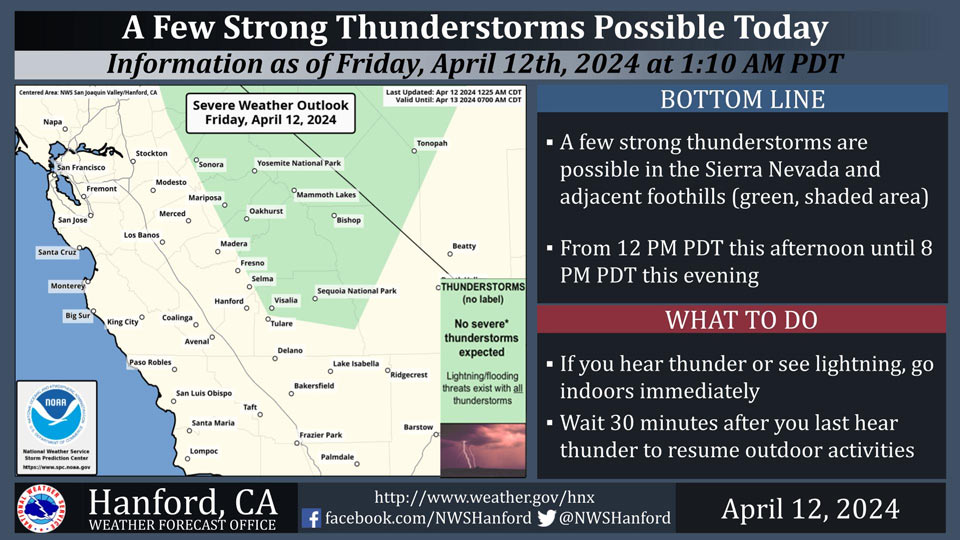
Possible Thunderstorms in Mariposa, Madera, Merced, Fresno, and Tuolumne Counties
April 12, 2024 - National Weather Service Hanford Office officials report a few strong thunderstorms are possible in the Sierra Nevada and adjacent foothills from 12 PM PDT this afternoon until 8 PM PDT this evening.
Small hail and wind gusts near 45 miles per hour are a couple of hazards associated with thunderstorms.
In addition to dangerous cloud to ground lightning strikes, any thunderstorm can produce intense rainfall rates, leading to localized flooding.
Area Forecast Discussion
National Weather Service Hanford CA
341 AM PDT Fri Apr 12 2024
&&
.KEY MESSAGES...
1. Warmer than average temperatures continue today, with high
temperatures still reaching 10 to 20 degrees above normal.
2. Another disturbance moves through Central California later
today through the weekend that will result in cooler
temperatures and a chance for precipitation.
3. Strong thunderstorms may develop Saturday afternoon and
evening.
4. Strong wind potential occurs mainly in the afternoons and
evenings on Friday and Saturday in eastern Kern County,
including the desert floor and slopes.
&&
.DISCUSSION...
A change in the weather will be ushered-in later today as
showers and thunderstorms move into Central California. While
afternoon temperatures will continue to reach into the 80s
today, widespread precipitation and cooler conditions will be
noted on Saturday. Currently, temperatures across Central
California are running some 2 to 6 degree above early this
morning. Yet, areas in the north end of the Central California
Interior will run behind on temperatures as areas like Merced
County are not expected to reach the 80 degree mark today. Ahead
of the change in the weather, winds will show a increase in
speeds across Central California as the influence of the upper
low (disturbance) nears the California Coast. Jet max winds will
be felt over the West Hills later today and this evening. A
wind advisory has been issued as peak wind gusts could reach 55
mph near sunset today. The upper low is expected to make
landfall on Saturday as unsettled weather returns to Central
California.
High-Res Short-range ensembles solutions favoring the onset of
precipitation near 2 to 4 PM PDT this Friday and mostly over the
Sierra Nevada. Ensemble mean upper level winds show between 50
to 60 mph winds perpendicular to the Sierra Nevada which support
good orographic lift. These strong winds increase confidence in
active weather today ahead of the main disturbance. High-Res
ensemble upper -air analysis this shows the landfall of the
upper low reaching the California Coast by Saturday. At that
time, Integrated Water Vapor Transport analysis show a possible
weak Atmospheric River reaching into Central California and
increase the potential for heavy precipitation. Currently,
Winter-Like Weather Advisories have been issued for locations
mostly above 6,000 feet where 6 inches and above of snow will be
observed. The Kern County Mountains were also included in the
advisories where a few inches of snow will impact the area.
Areas above 6,000 feet have a Probability of Exceedance (PoE) of
receiving 6 inches of snow in the 60 to 90 percent range. Areas
just below 6,000 feet fall in the PoE range of 40 to 50 percent
(which is still good for significant snow). While 6 inches is
unlikely closer to 3,000 feet, PoE for 1 to 2 inches is still in
the range of 40 to 50 percent. Therefore, snow is possible in
the Foothills on Saturday.
Lingering light precipitation expected to continue to Sunday as
the upper low slowly crosses California. Yet, by Sunday, cold
and stable air filters into the region as PoE of generating
convective activity diminishes to near zero percent. Ensemble
Cluster Analysis then shows a strong signal toward the passage
of the upper low into the Four-Corners area and away from
California. Cluster Analysis then points toward the development
of a ridge pattern going to mid-week. While the ridge pattern is
not very amplified, the ridge pattern will provide of some
warming. PoE of reaching the 75 degree mark across the valley
rises to near 80 percent by next Wednesday and Thursday. After
the weekend storm, Central California returns to dry and warm
for much of the week.
&&
.AVIATION...
A 20 to 40 percent chance of afternoon thunderstorms exist today
between 18Z today and 02Z Saturday for areas above 1000 feet
MSL and mostly on the east side of the Central California
Interior. VFR conditions expected across interior Central
California for at least the next 24 hours.
&&
.AIR QUALITY ISSUES...
None.
&&
.CERTAINTY...
The level of certainty for days 1 and 2 is high.
The level of certainty for days 3 through 7 is medium.
Certainty levels include low...medium...and high. Please visit
www.weather.gov/hnx/certainty.html for additional information
and/or to provide feedback.
&&
.HNX WATCHES/WARNINGS/ADVISORIES...
Wind Advisory from 4 PM this afternoon to 11 AM PDT Saturday
for CAZ300-308-313.
Winter Weather Advisory from 11 AM to 11 PM PDT Saturday for
CAZ323-325>331-333-334-336.
Source: NWS